1st May 2026 07:00
1 May 2026
Power Metal Resources PLC
("Power Metal" or the "Company")
Uranium Joint Venture
Fermi Exploration: Fertile Structure for Uranium Mineralisation Delineated on the Perch River Property
Power Metal Resources plc (AIM: POW, OTCQB: POWMF) is pleased to announce supplementary drill core sampling results from the Perch River Uranium Property in the Athabasca Basin, Saskatchewan. The Perch River Uranium Property ("Perch River" or the "Property") is held under Power Metal's uranium-focused joint venture with Fermi Exploration Ltd ("Fermi").
Following a combined geochemical and mineralogical review of results, from additional drill core samples collected from within the Rapids Fault Structure at Perch River, the Company considers the Rapids Fault Structure to be "fertile" with scope for significant uranium mineralisation at depth. This technical release provides an overview of the rationale behind the interpretation. The supplementary drill core samples, collected during December 2025, were selected from holes drilled in Fermi's June-July 2025 Perch River programme.
HIGHLIGHTS:
· Supplementary sampling of drill core from the Rapids Fault Structure at Perch River has confirmed a geochemically and mineralogically fertile environment for unconformity-related uranium deposits, evidenced by the presence of sudoite, hydrothermal tourmaline and dolomite within the Rapids Fault Structure.
· Drillhole PR25-01 returned boron levels of 779 ppm (parts per million), a critical pathfinder often associated with primary uranium mineralisation within a 100-metre proximity.
· Geochemical analysis confirmed the previously anomalous lead isotope results - such results serve as a direct proxy for significant uranium decay and are spread along a strike of at least 400m along the Rapids Fault Structure.
· The technical team concludes that the 2025 drilling intersected the distal, upper extent of the system. The convergence of high-temperature sudoite alteration, hydrothermal tourmaline and radiogenic lead suggests the hydrothermal core, which may contain an uranium deposit, remains untested at greater depths.
Sean Wade, Chief Executive Officer of Power Metal Resources PLC commented:
"These supplementary results fundamentally upgrade the prospectivity of the Perch River property. While our 2025 drill programme did not intersect primary uranium, the identification of classic near-miss indicators, confirms we have successfully drilled into the upper halo of a potentially fertile hydrothermal system. Crucially, the highly anomalous radiogenic lead acts as a direct vector, giving our technical team clear justification for potentially high-grade core at greater depths. This data transforms Perch River into our highest priority target for follow up drilling"
OVERVIEW
The Rapids Fault Structure on the Perch River Uranium property was drilled in 2025, at the time of the drill programme's completion, despite promising geology, no uranium was intersected and the programme was terminated. Routine analysis of the collected samples indicated the presence of a highly anomalous 206/204 lead isotope ratio (²⁰⁶Pb/²⁰⁴Pb), a geochemical proxy for uranium mineralisation, alongside positive mineralogical results. As such, additional drill core sampling was completed to better understand the Rapid Fault Structure's prospectivity and scope to host uranium mineralisation.
The results from the sampling indicate the Rapids Fault Structure to be mineralogically and geochemically fertile for the generation and hosting of unconformity-related uranium deposits, demonstrated by the presence of sudoite, dolomite and tourmaline - with associated geochemical anomalies, within the fault structure.
Fermi's Technical team considers that the 2025 drilling intersected the distal, upper extent of the system, with the high-temperature hydrothermal core, and potential uranium mineralisation inferred to exist at greater depths.
FURTHER INFORMATION
Background
Between June and July 2025, a six-hole, 1,563m NQ diameter (47.6 mm core) diamond core drilling programme (Table 1, Figure 1) centred on the Rapids Fault Structure was completed at the Perch River Property. The Rapids Fault Structure is a circa 650 m long, east-west trending, subvertical inferred fault/alteration system. Soil sampling during 2024 had identified coincident anomalous uranium, lead isotopes and other elements associated with unconformity-related mineralisation, above the Rapids Fault Structure, as detailed in the following release:
https://polaris.brighterir.com/public/power_metal_resources/news/rns/story/ryn9qkw
Following the July 2025 drill programme, routine geochemical analysis indicated the presence of a up to 242.8 (²⁰⁶Pb/²⁰⁴Pb) and 0.15 (²⁰⁷Pb/²⁰⁶Pb) from within the Rapids Fault Structure, this strong radiometric lead signature was inferred to potentially be related to uranium mineralisation at depth along the Rapids Fault Structure, as discussed in this release:
https://polaris.brighterir.com/public/power_metal_resources/news/rns/story/xpk13mr
The routine sampling completed during the drill programme in June-July 2025 was coarse, composed of composite samples, and greater sampling resolution and density, alongside additional testing was required to better establish the Rapids Fault Structure's prospectivity. This sampling was completed in December 2025, for which the results are presented herein.
Rapids Fault System
The Rapids Fault Structure is an east-west-trending subvertical apparent shear zone, located to the east, and likely related to the north-south-trending Font du Lac Fault , which crosses the centre of the Perch River Property. The fault structure introduces significant structural complexity to the Perch River Property, and prior to 2025, it had never received tested.
The system was identified through an airborne magnetic survey as a structure of interest following the anomalous soil and radon gas geochemical data overlying it. The fault system itself, and its dip were delineated through an Ambient Noise Tomography ("ANT") geophysical survey. The fault structure runs eastward for an apparent 650 m from the Font du Lac Fault in the west, with a secondary, unnamed, and wholly untested fault structure to the west of the Font du Lac Fault extending for over 4km, with magnetic characteristics similar to those of the Rapids Fault Structure. Based on ANT data, the Rapids Fault System may extend below the unconformity down to 1km (1.2km below ground level) or more.
The Rapids Fault Structure lacks the traditional graphite, which is spatially related to the majority of large uranium deposits in the Athabasca Basin1. As inferred from the ANT data, the intersection of the Rapids Fault System with the unconformity presents an area of complex palaeotopography. Such structural and topographic features have been widely documented as favourable sites for the generation of uranium deposits due to their capacity to focus and control hydrothermal fluid circulation at the unconformity2.
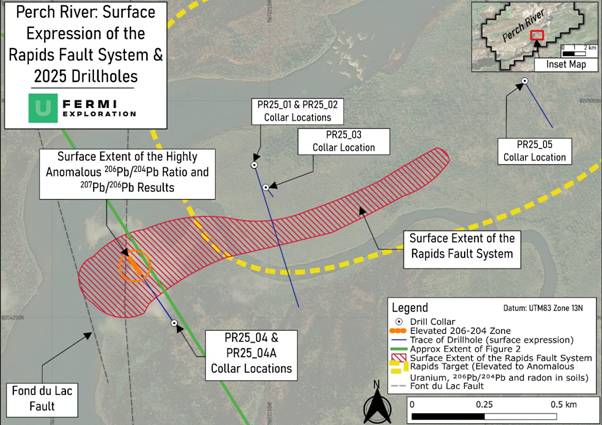
Notes: Drill collars & trace of the 2025 drilling shown with the location of the highly anomalous 206Pb/204Pb 207Pb/206Pb ratio results. Major local faulting, and the extent of the Rapids Zone, an area of highly anomalous geochemistry in soils determined through fieldwork in 2024 is also marked. No soil or radon sampling was carried out above the PR25-04A collar location; as such, geochemical anomalies could exist in this area.
Figure 1: Drill Programme Hole Location and Downhole Traces with Surface Expression of the Rapids Fault System
Sampling Programme
The supplementary drill core sampling was designed to increase sample density and provide material for a detailed petrological review, thereby refining the understanding of the Rapids Fault Structure in advance of future exploration on the property. The sampled intervals included areas which had tested elevated or anomalous readings for 206/204 Pb Ratio, Phosphorus and Uranium. This sampling acts to supersede the composite sampling, which was performed during the drilling on Perch River, and has increased the sampling density on the interval of interest by over ten times.
A total of 91 samples were collected from PR25_04A, eight samples from PR25_01 and six samples from PR25_05. These 105 samples were analysed for a full (partial and total leach) chemical suite by SRC GeoAnalytical labs, and Short Wave Infrared ("SWIR") spectroscopy by Axiom Exploration Group, Saskatoon. Petrographic analysis was carried out on ten samples, one from PR25_01, eight from PR25_04A and one from PR25_05 at Saint Mary's University, Halifax.
Summary of Unconformity Related Uranium Deposits
Unconformity-associated uranium deposits form via a reduction-oxidation (redox) reaction, where the mixing of oxidising, uranium-bearing fluids and reducing fluids causes uranium to precipitate. These deposits represent the final stage of prolonged hydrothermal activity, leaving a permanent mineralogical and geochemical alteration signature in the surrounding host rocks.
When highly reactive, metal-carrying brines move through a fault, they act to "cook" the surrounding hard rock, eating away the original hard minerals (like feldspar) and replacing them with soft clays. Through this process, results the almost total destruction of the original rock into illite and kaolinite clays. In both mineralised and unmineralised systems a mineral called sudoite (Al-Mg di-trioctahedral chlorite) was formed. Sudoite only forms when highly oxidising, magnesium-rich brines have been present in those rocks, as such, seeing massive sudoite and illite replacement is a positive sign for the fertility of an area1 3.
Also critical is the identification of an oxidation front, where the reducing fluids meet the uraniferous oxidising fluids. Where these fluids meet, the uranium is reduced from the oxidised fluids, which causes it to drop out of solution. This process generates much of the world-class uranium mineralisation found within the Athabasca Basin.
Although termed "unconformity-related uranium deposits", multiple deposits are found at a variety of depths below the unconformity1. World-class deposits such as Arrow and Triple R are found at 100-800m and 50-300 m below the unconformity, respectively4. Furthermore, deposits outside the Athabasca Basin, such as ACKIO5, highlight the scope for deep, basement-hosted uranium mineralisation.
Results: Mineralogical Review
The integration of SWIR analysis, thin-section petrography and geochemical analysis has provided a comprehensive understanding of the fluid history, and the potential fertility within the Rapids Fault Structure.
The dominant alteration mineral in the Rapids Fault Structure is white mica, which SWIR data confirms is moderately to highly phengitic; the shift towards a phengitic composition of the white mica infers a direct interaction with magnesium-iron-rich basinal brines - those brines are a crucial part of the generation of unconformity-related uranium deposits1.
Sudoite (a magnesium-aluminium chlorite) was identified deep within the fault structure in PR25-04A, between 375 m and 395 m downhole. This mineral typically dominates the innermost alteration core of unconformity-related uranium deposits1 6, indicating high temperatures and extreme fluid-to-rock ratios. Sudoite also correlates spatially with the highest radiogenic lead and uranium values.
Drillhole PR25-001 returned significantly elevated boron levels, peaking at 779 ppm (Table 2). This concentration equates to approximately 2.2% hydrothermal tourmaline by volume. In the context of Athabasca basement geology, boron values exceeding 500 ppm are considered a high-priority "near-miss" indicator, typically associated with uranium mineralisation in very close proximity-often within 100 metres7.
Hydrothermal tourmaline is a critical component of Athabascan uranium systems; in the basement, it serves as a highly regarded pathfinder and an expansive distal vector towards the primary fluid conduit. Of particular note is the intense sodium Na2O depletion observed in the geochemical data. While not yet confirmed via thin section, this chemical signature implies the tourmaline may be alkali-deficient magnesiofoitite. This specific mineral species is significant as it shares a direct temporal and genetic relationship with the primary uranium mineralising event elsewhere in the Athabasca Basin 8, 9.
Alongside the sudoite, late-stage hydrothermal dolomite is observed as fracture infill. This carbonate phase is inferred elsewhere in the basin to represent the neutralisation of acidic, uraniferous basinal brines as they migrate through structural conduits10. The precipitation of carbonate is thermodynamically linked to temperature shifts and fluid neutralisation that drastically decrease the stability of uranium within the hydrothermal fluids, driving primary uranium mineralisation11. When coincident with pathfinder elements such as nickel, arsenic, and uranium, these carbonates serve as a diagnostic signal of a fertile hydrothermal conduit1 12.
Within the Rapids Fault Structure, specifically at a downhole depth of 327.8 m (308 m True Depth "TD") in PR25-004A, this "diagnostic" lithogeochemical relationship may be demonstrated; elevated calcium (7.01 wt %) is associated with anomalous nickel (63.9 ppm), and elevated (85th percentile) arsenic (0.67 ppm), indicating the potential fertility of the Rapids Fault Structure.
Drillhole PR25-05, located 500 m to the east of PR25-01, and 760 m east of PRE25-04A, also along the Rapids Fault Structure, was also sampled between 230-238.2 m downhole (201.2-208.3 m TD) and did not yield a fertile mineralogical or geochemical signature.
Results: Lead Isotopes Review
The Rapid Fault Structure Lead isotopic signature remains highly indicative of nearby uranium mineralisation, as demonstrated by:
· In drillhole PR25-04A, highly anomalous lead isotope ratios were isolated at downhole depth intervals between 307.8 to 312.7 metres (289.2-293.8 m TD) and 384 to 394.8 metres (360.8-370.2 m TD).
· The deeper intersection in PR25-04A (375 to 395 metres; 352-371 m TD) yielded the highest radiogenic lead values (²⁰⁶Pb/²⁰⁴Pb > 100), which coincide directly with both sudoite alteration and the highest recorded uranium values of 130 ppm.
· In drillhole PR25-01, a specific anomalous ²⁰⁶Pb/²⁰⁴Pb peak was identified at 198.9 metres downhole (140.6 m TD), this indicates that the highly anomalous lead isotopes are not localised within one drillhole, but are spread along strike at least 400m .
· This peak value in PR25-01 at 198.9 metres downhole is spatially coincident with elevated boron results (up to 779 ppm B) derived from hydrothermal tourmaline. This relationship is critical, as boron is present in tourmaline, which is inferred from elsewhere to be syn-U mineralisation.
Lead isotope data from the sampled intervals is summarised in Table 2.
Inferred Geological Model
The results from the 2025 sampling programme indicate that drillhole PR25-01 intersected the upper, illite and boron-rich (dravite) distal extent of the hydrothermal alteration system. In contrast, PR25-04A reached a lower structural level characterised by sudoite and illite dominance, which typically signifies closer proximity to the high-temperature hydrothermal core of the system.
The integration of lead isotope, geochemical, and mineralogical data-specifically the pathfinder associations of boron, nickel, arsenic, and copper-demonstrates that the Rapids Fault Structure has a high potential as a fertile mineralising structure. Fermi's Technical Team infers that the 2025 drilling was completed at depths too shallow to intercept the primary unconformity-style mineralisation. Consequently, significant potential for a major uranium discovery remains at greater depths along the fault structure.
TECHNICAL DETAILS
Drillhole Locations
Table 1: Drillhole Details on the Perch River Property
Drillhole ID | Longitude | Latitude | Elevation (m) | Azimuth (degrees) | Dip (degrees) | Downhole Depth (m) |
PR25-001 | 508356 | 6552606 | 347 | 162 | -45 | 377 |
PR25-002 | 508356 | 6552606 | 230 | - | -90 (vertical) | 230 |
PR25-003 | 508377 | 6552566 | 203 | 141 | -84 | 203 |
PR25-004 | 508830 | 6552760 | 389 | 317 | -60 | 119 |
PR25-004A | 508214 | 6552325 | 239 | 318 | -70 | 395 |
PR25-005 | 508830 | 6552760 | 347 | 143 | -61 | 239 |
Table Notes: Grid references stated in UTM Zone 13N NAD83 datum. NQ (47.6mm) core diameter.
Technical Background - Lead Isotope Results
Lead 206 ("206Pb") is an isotope of lead that is derived from the radioactive decay of uranium, while lead 204 ("204Pb") is the isotope of lead that was derived from cosmogenic sources (i.e. supernova collapse). Isotope 204Pb remains a constant within geological systems. By comparing the values of both isotopes in a sample, it is possible to determine what proportion of lead was derived from uranium.
There are five stable isotopes of lead, and lead-207 is also relevant when assessing the suitability of an area for Paleoproterozoic-Mesoproterozoic unconformity-related uranium deposits1-the style of mineralisation targeted by Fermi within the Athabasca Basin. Such mineralisation typically exhibits low 207Pb/206Pb ratios, reflecting both the initial ratio of the two uranium parent isotopes (²³⁵U/²³⁸U) and the shorter half-life of ²³⁵U relative to ²³⁸U. This distinctive isotopic fingerprint, when compared with the barren sandstones of the Athabasca and analogous basins, has led to the use of 207Pb/206Pb-alongside 206Pb/204Pb-as a potential geochemical vector toward unconformity-related uranium mineralisation.
Typically, the background 206Pb/204Pb ratio is between 18 and 19; results between 20 and 30 suggest an input from radiogenic decay, and results over 40 suggest strongly radiogenic decay with a direct association with uranium13.
A 206Pb/204Pb ratio of 100 or greater is comparatively rare, and has been found associated with mineralisation in similar geological settings as the Athabasca Basin3. For 207Pb/206Pb, a ratio of below 0.75 is considered background, between 0.75 and 0.4 to be anomalous, 0.4 to 0.2 to be strongly anomalous, and <0.2 to be highly anomalous, and previously located within mineralised zones.
Lead and uranium display distinct geochemical behaviours under varying geological conditions. Whereas uranium can be readily mobilised as soluble uranyl complexes, lead typically remains fixed or undergoes limited redistribution. Consequently, the distribution of lead-particularly radiogenic Pb derived from uranium decay-can serve as a secondary vector to uranium mineralisation.
Technical Background - Short Wave Infrared and Mineralogical Review
Short-Wave Infrared (SWIR) spectroscopy is a widely utilised analytical technique in the exploration of unconformity-related uranium deposits. During hydrothermal alteration-the process that forms these deposits-highly reactive, high-temperature, magnesium-rich brines interact with the surrounding host rocks. This interaction breaks down original hard minerals and replaces them with complex, fine-grained clay minerals.
Because these alteration clays are typically microscopic and visually indistinguishable in drill core which contains a high proportion of silica, making other methods (such as X-Ray Diffraction) ineffective, SWIR spectroscopy is employed to accurately map them alongside traditional petrographic work. The technology measures light reflected off a rock sample, creating a unique spectral fingerprint based on molecular bonds at specific wavelengths between 450 nm (visible light) to 3,500 nm. By analysing these fingerprints, petrologists can track subtle chemical changes that act as vectors toward a mineralised core.
As noted above, the dominant alteration mineral identified within the Rapids Fault Structure is white mica, comprising up to 90% of the assemblage in multiple intervals (e.g., 309.4 m, 325.2 m, 371.0 m). However, the composition of this white mica is not uniform and provides crucial vectoring data. In the Athabasca Basin, normal, potassium-rich "diagenetic" illite forms prior to any mineralisation and typically exhibits an Al-OH absorption feature at roughly 2200 to 2205 nm.
When high-temperature basinal brines interact with this background illite, magnesium and iron substitute for aluminium, altering the mineral into phengitic illite. This substitution causes the SWIR absorption feature to shift to longer wavelengths as the introduction of the larger magnesium ion "stretches" the Al-OH bonds in the crystal lattice, causing them to absorb slightly different wavelengths. In drillhole PR25-04A, the Al-OH wavelength values in highly radiogenic zones (e.g., 384.4 m, 388.5 m) are consistently between 2211 nm and 2221 nm, confirming that the white mica is moderately to highly phengitic. This distinct shift acts as a footprint, confirming the fault structure acted as a primary fluid conduit that received a significant influx of the Mg-Fe rich basinal brines required for uranium deposition.
Closer to the core of the hydrothermal system, these magnesium-rich brines convert illite into a critical species of chlorite known as sudoite. Sudoite is temporally and spatially related to primary uranium mineralisation across multiple Athabasca deposits, typically forming a diagnostic high-temperature alteration "envelope" around orebodies.
Sudoite contains abundant aluminium and magnesium bonded to hydroxide groups, exhibiting both a strong Mg-OH feature and a very strong Al-OH/Fe-OH feature in SWIR analysis. In multiple intervals within PR25-04A (at 375.9 m, 393.1 m, and 394.8 m), this spectral "fingerprint" falls precisely within the diagnostic 2235-2253 nm range, paired with a secondary feature around 2330-2340 nm, representing iron-magnesium in the crystal structure. Corroborated by thin-section reviews, these spectral signatures confirm the presence of elevated sudoite. Together with the phengitic illite data, this successfully maps the hydrothermal fluid pathways and directs future exploration downward toward the high-temperature core of the mineralised system.
Summarised Geochemical Results
Table 2: Geochemical Results from the supplementary sampling of the Rapids Fault Structure for calcium, uranium, boron, and 206/204Lead and 207/206Lead ratios from the PR25-01, PR25-04A and PR25-05 drillholes. Note, table 1 for the locations and inclinations of the DDHs
Drillhole | Depth (m) | Assay Result | Lead Isotope Ratios | |||
CaO wt % (total) | U ppm (partial) | B ppm (fusion) | 206/204Pb ratio (partial) | 207/206Pb ratio (partial) | ||
PR25-001 | 190 | 0.16 | 9.67 | 131 | 38.00 | 0.43 |
PR25-001 | 191.4 | 0.25 | 3.93 | 115 | 26.14 | 0.61 |
PR25-001 | 193.2 | 0.36 | 6.68 | 228 | 82.50 | 0.30 |
PR25-001 | 196.15 | 0.38 | 2.10 | 453 | 17.08 | 0.85 |
PR25-001 | 197 | 2.21 | 3.71 | 681 | 19.08 | 0.77 |
PR25-001 | 198 | 0.32 | 2.79 | 721 | 26.00 | 0.59 |
PR25-001 | 198.9 | 0.37 | 8.48 | 779 | 185.00 | 0.20 |
PR25-001 | 199.9 | 0.18 | 2.11 | 489 | 18.08 | 0.83 |
PR25-004A | 297.7 | 1.74 | 0.91 | 76 | 23.60 | 0.62 |
PR25-004A | 298.5 | 2.26 | 1.43 | 77 | 38.00 | 0.51 |
PR25-004A | 299.5 | 5.63 | 3.15 | 103 | 25.67 | 0.64 |
PR25-004A | 301 | 1.23 | 5.23 | 63 | 35.50 | 0.48 |
PR25-004A | 302 | 0.41 | 3.74 | 49 | 25.67 | 0.66 |
PR25-004A | 302.8 | 0.56 | 5.05 | 73 | 29.88 | 0.55 |
PR25-004A | 303.8 | 0.68 | 4.68 | 72 | 25.78 | 0.63 |
PR25-004A | 304.8 | 0.15 | 2.86 | 98 | 17.88 | 0.86 |
PR25-004A | 306.8 | 0.07 | 1.91 | 14 | 36.00 | 0.50 |
PR25-004A | 306.9 | 0.22 | 2.53 | 68 | 27.20 | 0.63 |
PR25-004A | 307.8 | 0.43 | 1.56 | 15 | 107.50 | 0.33 |
PR25-004A | 308.8 | 2.48 | 7.10 | 45 | 43.40 | 0.41 |
PR25-004A | 309.4 | 1.84 | 3.81 | 48 | 48.33 | 0.34 |
PR25-004A | 310.9 | 0.16 | 4.17 | 22 | 114.00 | 0.26 |
PR25-004A | 311.9 | 0.24 | 2.02 | 43 | 32.00 | 0.47 |
PR25-004A | 312.7 | 0.29 | 10.00 | 57 | 112.50 | 0.27 |
PR25-004A | 313.6 | 0.40 | 5.18 | 66 | 42.75 | 0.44 |
PR25-004A | 314.4 | 0.19 | 3.10 | 45 | 54.00 | 0.44 |
PR25-004A | 315.3 | 3.91 | 4.39 | 116 | 41.33 | 0.44 |
PR25-004A | 315.5 | 1.08 | 5.23 | 132 | 30.50 | 0.52 |
PR25-004A | 316.7 | 1.72 | 6.10 | 64 | 40.60 | 0.42 |
PR25-004A | 317.5 | 0.52 | 5.81 | 58 | 37.00 | 0.44 |
PR25-004A | 320.65 | 0.25 | 10.00 | 61 | 81.50 | 0.25 |
PR25-004A | 321.6 | 0.62 | 5.08 | 58 | 51.67 | 0.41 |
PR25-004A | 322.5 | 0.40 | 3.11 | 100 | 55.00 | 0.41 |
PR25-004A | 324.3 | 0.44 | 4.38 | 97 | 44.50 | 0.38 |
PR25-004A | 325.2 | 1.12 | 12.4 | 138 | 83.17 | 0.24 |
PR25-004A | 326.3 | 7.00 | 2.5 | 38 | 48.20 | 0.37 |
PR25-004A | 327.8 | 7.01 | 3.03 | 43 | 25.38 | 0.59 |
PR25-004A | 330.8 | 2.65 | 2.18 | 63 | 21.33 | 0.77 |
PR25-004A | 331.9 | 3.62 | 1.28 | 45 | 16.64 | 0.86 |
PR25-004A | 333 | 0.77 | 0.66 | 57 | 15.59 | 0.94 |
PR25-004A | 333.6 | 0.64 | 2.70 | 72 | 23.13 | 0.70 |
PR25-004A | 334.5 | 1.14 | 2.28 | 32 | 50.00 | 0.42 |
PR25-004A | 335.6 | 0.37 | 5.54 | 51 | 68.00 | 0.32 |
PR25-004A | 336.8 | 2.50 | 7.17 | 36 | 15.82 | 0.94 |
PR25-004A | 338.1 | 0.72 | 2.89 | 75 | 22.00 | 0.71 |
PR25-004A | 339 | 2.71 | 2.94 | 43 | 17.95 | 0.85 |
PR25-004A | 340.6 | 2.82 | 1.84 | 70 | 20.80 | 0.74 |
PR25-004A | 341.3 | 1.59 | 1.08 | 65 | 17.11 | 0.88 |
PR25-004A | 341.8 | 1.01 | 1.75 | 80 | 15.50 | 0.91 |
PR25-004A | 342.8 | 0.32 | 1.85 | 55 | 17.88 | 0.88 |
PR25-004A | 343.7 | 0.85 | 1.24 | 46 | 16.56 | 0.91 |
PR25-004A | 344.4 | 0.95 | 2.04 | 57 | 22.50 | 0.67 |
PR25-004A | 345.3 | 0.52 | 1.81 | 59 | 30.00 | 0.55 |
PR25-004A | 346.55 | 0.75 | 2.27 | 59 | 38.00 | 0.39 |
PR25-004A | 347.3 | 0.56 | 2.27 | 79 | 25.50 | 0.64 |
PR25-004A | 348 | 0.84 | 1.63 | 41 | 36.50 | 0.55 |
PR25-004A | 349.1 | 0.27 | 15.00 | 62 | 50.00 | 0.39 |
PR25-004A | 350.5 | 0.24 | 2.07 | 49 | 21.00 | 0.71 |
PR25-004A | 351.5 | 2.81 | 12.2 | 60 | 31.50 | 0.52 |
PR25-004A | 353 | 1.24 | 8.63 | 53 | 72.50 | 0.28 |
PR25-004A | 354.6 | 0.83 | 1.50 | 32 | 27.67 | 0.58 |
PR25-004A | 355.1 | 0.48 | 1.09 | 32 | 17.44 | 0.87 |
PR25-004A | 356.2 | 1.42 | 1.54 | 24 | 21.67 | 0.72 |
PR25-004A | 357 | 7.46 | 0.77 | 29 | 27.00 | 0.65 |
PR25-004A | 358.05 | 0.77 | 19.7 | 43 | 38.00 | 0.43 |
PR25-004A | 359.2 | 1.56 | 2.50 | 40 | 26.14 | 0.61 |
PR25-004A | 359.4 | 1.00 | 2.32 | 35 | 82.50 | 0.30 |
PR25-004A | 361 | 2.00 | 6.12 | 23 | 17.08 | 0.85 |
PR25-004A | 362.2 | 1.71 | 7.74 | 39 | 19.08 | 0.77 |
PR25-004A | 363 | 1.15 | 2.81 | 84 | 26.00 | 0.59 |
PR25-004A | 364.3 | 1.38 | 2.05 | 69 | 185.00 | 0.20 |
PR25-004A | 365.2 | 0.59 | 4.87 | 27 | 18.08 | 0.83 |
PR25-004A | 365.3 | 0.37 | 4.06 | 33 | 23.60 | 0.62 |
PR25-004A | 366.3 | 0.38 | 18.8 | 41 | 38.00 | 0.51 |
PR25-004A | 367.3 | 0.40 | 12.5 | 27 | 25.67 | 0.64 |
PR25-004A | 371 | 0.20 | 2.02 | 35 | 35.50 | 0.48 |
PR25-004A | 371 | 0.67 | 30.4 | 52 | 25.67 | 0.66 |
PR25-004A | 371.7 | 1.26 | 2.65 | 25 | 29.88 | 0.55 |
PR25-004A | 373.5 | 3.69 | 4.27 | 30 | 25.78 | 0.63 |
PR25-004A | 374.4 | 1.38 | 9.22 | 21 | 17.88 | 0.86 |
PR25-004A | 375.9 | 4.43 | 0.58 | 22 | 36.00 | 0.50 |
PR25-004A | 376.6 | 0.26 | 1.09 | 121 | 27.20 | 0.63 |
PR25-004A | 377 | 0.15 | 3.99 | 36 | 107.50 | 0.33 |
PR25-004A | 378.1 | 0.28 | 2.60 | 110 | 43.40 | 0.41 |
PR25-004A | 378.9 | 0.33 | 3.80 | 83 | 48.33 | 0.34 |
PR25-004A | 384 | 1.28 | 130 | 92 | 114.00 | 0.26 |
PR25-004A | 384.4 | 0.22 | 2.96 | 47 | 32.00 | 0.47 |
PR25-004A | 385 | 1.12 | 23.8 | 49 | 112.50 | 0.27 |
PR25-004A | 386 | 0.70 | 9.91 | 30 | 42.75 | 0.44 |
PR25-004A | 387.5 | 2.48 | 9.08 | 44 | 54.00 | 0.44 |
PR25-004A | 388.5 | 0.56 | 0.51 | 41 | 41.33 | 0.44 |
PR25-004A | 389.4 | 0.20 | 1.74 | 40 | 30.50 | 0.52 |
PR25-004A | 391 | 1.17 | 13.5 | 24 | 40.60 | 0.42 |
PR25-004A | 391.9 | 5.41 | 1.99 | 42 | 37.00 | 0.44 |
PR25-004A | 393.1 | 0.27 | 4.48 | 36 | 81.50 | 0.25 |
PR25-004A | 394 | 0.58 | 1.78 | 46 | 51.67 | 0.41 |
PR25-004A | 394.2 | 3.84 | 6.76 | 46 | 55.00 | 0.41 |
PR25-004A | 394.8 | 0.48 | 2.19 | 32 | 44.50 | 0.38 |
PR25-005 | 230.6 | 0.43 | 5.05 | 4 | 83.17 | 0.24 |
PR25-005 | 232 | 3.08 | 1.32 | 2 | 48.20 | 0.37 |
PR25-005 | 234.4 | 2.31 | 0.68 | 2 | 25.38 | 0.59 |
PR25-005 | 234.9 | 2.32 | 0.45 | 2 | 21.33 | 0.77 |
PR25-005 | 237.3 | 3.00a | 0.78 | 2 | 16.64 | 0.86 |
PR25-005 | 238.2 | 2.02 | 2.78 | 2 | 15.59 | 0.94 |
GLOSSARY
²⁰⁶Pb/²⁰⁴Pb Lead Isotopes | A measure of the ratio of uranium-derived lead (known as "radiogenic lead" ²⁰⁶Pb) to non-radiogenic "primordial" lead (²⁰⁴Pb). High ratios may suggest uranium mineralisation. |
²⁰⁷Pb/²⁰⁶Pb Lead Isotopes | Lower ²⁰⁷Pb/²⁰⁶Pb ratios (typically around 0.15-0.20 in Athabasca-style systems) are diagnostic of radiogenic lead derived from uranium minerals. |
Alteration
| A change in the mineral composition and texture of a rock due to hydrothermal fluids, heat, pressure, or other geological processes. It often occurs near ore deposits and can serve as an exploration guide. |
Airborne Magnetic Survey | A geophysical technique conducted from an aircraft to measure variations in the Earth's magnetic field, which was used to initially identify the Rapids Fault System as a structure of interest. |
Basement Rocks | Older crystalline rocks (granite, gneiss, etc.) that lie beneath younger sedimentary layers. In the Athabasca Basin, uranium mineralisation often forms at or just below this contact. |
Chlorite Alteration | A type of chemical alteration in which chlorite (a green, iron-rich mineral) forms in response to hydrothermal fluids. Often found near uranium deposits as part of the alteration halo. |
Composite Sample: | A representative sample created by physically combining multiple discrete rock or drill core samples collected over a specified length or area. This method provides a general, average geochemical signature for a broader interval, though it sacrifices the fine-scale resolution required to isolate narrow, specific mineralogical or geochemical samples .Such samples are routinely collected during drilling campaigns. |
Diamond Drilling | A method that uses a diamond-encrusted drill bit to extract cylindrical rock samples (core) from beneath the surface. The exploration programme utilised NQ-sized core, which has a diameter of 75.7 millimetres. |
Geochemical Analysis | The comprehensive laboratory testing of rock samples for a full chemical suite to ascertain the concentration of various elements. This analysis evaluates the presence of elements like calcium, uranium, and boron to gauge the mineralogical fertility of the rock. |
Subvertical
| Describes a geological feature (e.g., fault, vein, or rock layer) that is steeply inclined, close to vertical-typically with a dip angle between about 70° and 90°. |
Structurally Complex
| Describes a rock or geological area that has undergone multiple phases of deformation, resulting in a mix of folds, faults, shears, and fractures. Such areas can host mineralisation due to enhanced fluid flow pathways. |
Short-Wave Infrared (SWIR) Spectroscopy | A mineral identification method based on the infrared absorption spectra of minerals. Useful for detecting clays and alteration minerals associated with hydrothermal system |
Petrographic Analysis (Thin-Section Petrography) | The microscopic evaluation of rock samples to comprehend their fluid history and mineralogical composition |
REFERENCES
1 Jefferson, C.W., Thomas, D.J., Gandhi, S.S., Ramaekers, P., Delaney, G., Brisbin, D., Cutts, C., Portella, P. and Olson, R.A. (2007) 'Unconformity-associated uranium deposits of the Athabasca Basin, Saskatchewan and Alberta', Geological Survey of Canada Bulletin, 588, pp. 23-67.
2 Li, P., Chi, G., Bethune, K.M., Thomas, D. and Zaluski, G. (2015) 'Topographic features of the sub-Athabasca Group unconformity surface in the southeastern Athabasca Basin and their relationship to uranium ore deposits', Canadian Journal of Earth Sciences, 52(10), pp. 904-913.
3 Kister, P., Beaufort, D., Lantenois, S., Quirt, D. and Cuney, M. (2006) 'Mineralogy and geochemistry of the host-rock alterations associated with the Shea Creek unconformity-type uranium deposits (Athabasca Basin, Saskatchewan, Canada)', Clays and Clay Minerals, 54(4), pp. 483-494.
4 Mount, S., Potter, E.G., Yang, Z., Fayek, M., Powell, J.W., Chi, G. and Rizo, H. (2022) 'Formation of the high-grade Triple R uranium deposit revealed by Fe and S isotopes in pyrite', Geochemistry: Exploration, Environment, Analysis, 22(1), p. 23.
5 https://baselode.com/projects/hook-project/
6 Alexandre, P., Kyser, K., Thomas, D., Polito, P. and Marcano, M.C. (2005) 'Alteration mineralogy and stable isotope geochemistry of Paleoproterozoic basement-hosted unconformity-type uranium deposits in the Athabasca Basin, Canada', Economic Geology, 100(8), pp. 1547-1563.
7 Sopuck, V. J., de Carle, A. L., Wray, E. M., and Cooper, B. (1983). "The use of lithogeochemistry in the search for unknown uranium deposits in the Athabasca Basin, Saskatchewan." In: Geology of Uranium Deposits, CIM Special Volume 33, pages 341-362.
8 Rosenberg, P.E. and Foit, F.F. (2006) 'Magnesiofoitite from the uranium deposits of the Athabasca Basin, Saskatchewan, Canada', The Canadian Mineralogist, 44(4), pp. 959-965.
9 Adlakha, E.E., Hattori, K., Davis, W.J. and Boucher, B. (2017) 'Characterizing fluids associated with the McArthur River U deposit, Canada, based on tourmaline trace element and stable (B, H) isotope compositions', Chemical Geology, 466, pp. 417-435.
10 Chi, G., Bosman, S. and Card, C. (2013) 'Numerical modeling of fluid pressure regime in the Athabasca basin and implications for fluid flow models related to the unconformity-type uranium mineralization', Journal of Geochemical Exploration, 125, pp. 8-19.
11 Kalintsev, A., Migdisov, A., Alcorn, C., Baker, D.R. and Brugger, J. (2021) 'Uranium carbonate complexes demonstrate drastic decrease in stability at elevated temperatures', Communications Chemistry, 4(1), p. 119.
12 Sopuck, V.J., de Carle, A.L., Wray, E.M. and Cooper, B. (1983) 'The use of lithogeochemistry in the search for unknown uranium deposits in the Athabasca Basin, Saskatchewan', in Parslow, G.R. (ed.) Geology of Uranium Deposits. Montreal: Canadian Institute of Mining and Metallurgy (CIM Special Volume 33), pp. 341-362.
13 Quirt, D. and Benedicto, A. (2020) 'Lead isotopes in exploration for basement-hosted structurally controlled unconformity-related uranium deposits: Kiggavik Project (Nunavut, Canada)', Minerals, 10(6), p. 512.
QUALIFIED PERSON STATEMENT
The technical information contained in this announcement has been read and approved by Mr Nick O'Reilly (MSc, DIC, MIMMM QMR, MAusIMM, FGS), who is a qualified geologist and acts as the Qualified Person under the AIM Rules - Note for Mining and Oil & Gas Companies. Mr O'Reilly is a Principal consultant working for Mining Analyst Consulting Ltd which has been retained by Power Metal Resources PLC to provide technical support.
This announcement contains inside information for the purposes of Article 7 of the Market Abuse Regulation (EU) 596/2014 as it forms part of UK domestic law by virtue of the European Union (Withdrawal) Act 2018 ("MAR"), and is disclosed in accordance with the Company's obligations under Article 17 of MAR.
For further information please visit https://www.powermetalresources.com/ or contact:
Power Metal Resources plc | |
Sean Wade (Chief Executive Officer)
| +44 (0) 20 3778 1396 |
SP Angel Corporate Finance LLP (Nomad and Joint Broker) | |
Ewan Leggat/Jen Clarke
| +44 (0) 20 3470 0470 |
Tamesis Partners LLP (Joint Broker) | |
Richard Greenfield/Charlie Bendon | +44 (0) 20 3882 2868 |
BlytheRay (PR Advisors) Tim Blythe/Megan Ray/Alastair Roberts |
+44 (0) 20 7138 3204 |
NOTES TO EDITORS
Power Metal Resources plc - Background
Power Metal Resources plc (AIM: POW, OTCQB: POWMF) is a London-listed metals exploration company which finances and manages global resource projects and is seeking large scale metal discoveries.
The Company has a principal focus on opportunities offering district scale potential across a global portfolio including precious, base and strategic metal exploration in North America, Africa, Saudi Arabia, Oman and Australia.
Project interests range from early-stage greenfield exploration to later-stage prospects currently subject to drill programmes.
Power Metal will develop projects internally or through strategic joint ventures until a project becomes ready for disposal through outright sale or separate listing on a recognised stock exchange thereby crystallising the value generated from our internal exploration and development work.
Value generated through disposals will be deployed internally to drive the Company's growth or may be returned to shareholders through share buy backs, dividends or in-specie distributions of assets.
Related Shares:
Power Metal Resources PLC