20th May 2026 07:00
20 May 2026
East Star Resources Plc
("East Star" or the "Company")
Piket Project: Large Copper-Gold Target Identified
Large potential lithocap-hosted Cu-Au porphyry or epithermal system identified at Piket Project
East Star Resources Plc (LSE:EST), the Kazakhstan-focused gold and copper exploration and development company, is pleased to announce the first results from exploration at the Company's Piket Licence which was awarded in 2025. Recent geological mapping, hyperspectral interpretation and geochemical sampling have identified a large and geochemically anomalous lithocap as a potential host for a copper-gold porphyry or epithermal system. The work has significantly enhanced the Company's understanding of the regional geological setting and identified one large priority target for follow-up exploration at the Symbyl 2 Prospect area.
Highlights
· Recognition of a large-scale alkaline intrusive system geologically similar to the Macquarie Arc in Australia and younger alkalic porphyry systems in British Columbia, Canada
· Extensive advanced argillic alteration system defined over an area of 8km x 3km
· Soil sampling has outlined a 2km x 2km multi-element anomaly at the Symbyl 2 Prospect with coherent Au-Mo-Bi-Sn-W anomalism and gold values up to 0.2g/t Au
· The Symbyl 2 Prospect identified as the priority target with intense quartz-pyrophyllite-alunite alteration and evidence of oxidised sulphides and porphyry-style "A" veins
· Low sulfidation epithermal Au-Ag veins identified approximately 5km east of the main alteration corridor, confirming district-scale fertility and preservation of the epithermal environment
· Next steps to advance Symbyl 2 to include detailed mapping and systematic sampling of historic trench material and additional rock chip sampling over defined anomalies
Alex Walker, CEO of East Star Resources, commented:
"We are delighted with the progress made at Piket which has again demonstrated that our team can identify and acquire ground, and conduct the initial field work on prospective targets, in a single season. The positive results from this work are a strong demonstration that our strategy for porphyry target generation in Kazakhstan is working well and we are looking forward to the next phase of work to advance the project to drill-ready status."
To watch a video of Christopher van Wijk, Technical Director, discussing this announcement, visit: https://eaststarplc.com/link/Pw7j3P.
Large Alkalic Intrusive System Identified
Recent geological interpretation has recognised an alkaline intrusive suite at Piket with geological characteristics comparable to major alkalic copper-gold porphyry districts, including the Macquarie Arc in New South Wales and younger alkalic porphyry systems in British Columbia, Canada.
Field mapping confirmed the presence of classic alkalic alteration assemblages within monzonitic intrusions, including hematite-dusted potassium feldspar alteration ("Red Rock Alteration") and epidote-chlorite alteration associated with hornblende-bearing intrusive rocks.
The recognition of this geological setting substantially increases the prospectivity of the broader project area for both porphyry copper-gold mineralisation and associated epithermal gold-silver systems.
Furthermore, the Company believes that the regional potential for additional alkalic-related porphyry and epithermal systems remains underexplored and warrants broader scale regional targeting.
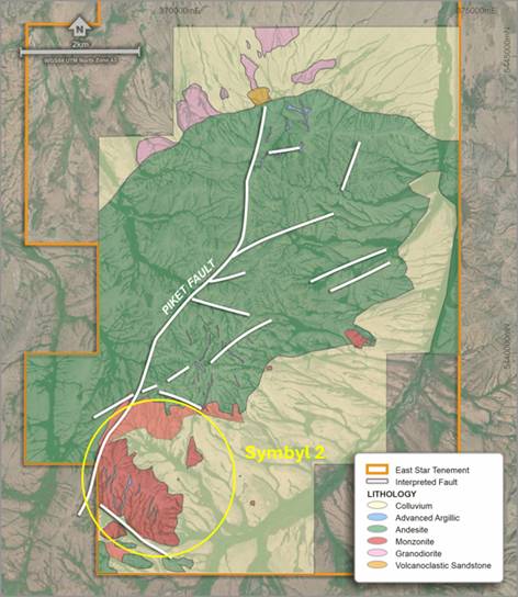
Figure 1 - Geology Map of the Piket Project
Extensive Lithocap Alteration Corridor
Exploration at Piket has defined a large advanced argillic alteration ("AAA") system extending approximately 8km in strike length and 3km in width. The Piket Trend is dominated by lithocap-related alteration facies, interpreted to represent the upper portions of a large hydrothermal system. Over the past several decades, lithocap environments have become increasingly important exploration targets globally as many new porphyry discoveries are concealed beneath advanced argillic alteration zones or lithocaps.
Ground validation work confirmed the quality and reliability of the satellite hyperspectral products, which were used extensively to map alteration mineralogy across the project (See Figure 1). Interpretation of alteration zonation and geology suggests that the deeper portions of the hydrothermal system may be exposed in the southern portion of the corridor, particularly around the Symbyl 2 Prospect. This may reflect structural tilting or block faulting along the interpreted Piket Fault.
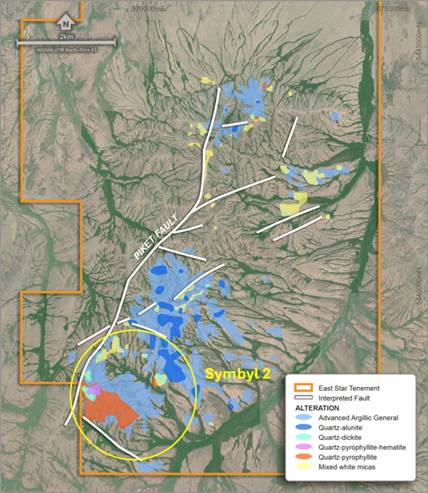
Figure 2 - Alteration map of the Piket Project
Symbyl 2 Identified as Priority Target
The Symbyl 2 prospect has emerged as the highest priority target within the project area. Mapping identified extensive zones of intense advanced argillic alteration characterised by a quartz-pyrophyllite-alunite assemblage, hematite-bearing fractures and veins, and evidence of ex-sulphide textures.
Importantly, minor porphyry-style quartz "A" veins were identified within the lithocap alteration assemblage, suggesting some degree of telescoping between porphyry and epithermal environments.
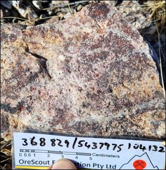
Figure 3 - Qtz "A" veins overprinted by advanced argillic alteration
Propylitic alteration within the surrounding host monzonite increases toward the Symbyl 2 lithocap, with increasing hematite dusting of feldspars and epidote-chlorite alteration of hornblende-bearing lithologies.
The combination of alteration intensity, structural preparation, pathfinder geochemistry and porphyry-style veining indicates Symbyl 2 represents the most compelling target for a concealed copper-gold porphyry system.
Soil Geochemistry defines a large Multi-Element Anomaly
Soil sampling conducted at the end of 2025 has further strengthened the prospectivity of the Symbyl 2 target area. Sampling defined a coherent 2km x 2km geochemical anomaly with elevated gold values of up to 0.2g/t Au as well as multiple pathfinder elements commonly associated with fertile porphyry systems, including molybdenum (Mo), bismuth (Bi) tin (Sn) and tungsten (W), all of which are high level indicators of fertile porphyry systems, commonly found in lithocaps above porphyry systems.
Gold anomalism appears spatially associated with the southern portion of the system and is concentrated within drainage systems adjacent to the lithocap. Molybdenum anomalism greater than 5ppm is preserved throughout multiple intervals of the lithocap system, further supporting the interpretation of a fertile hydrothermal environment (See Figure 3).
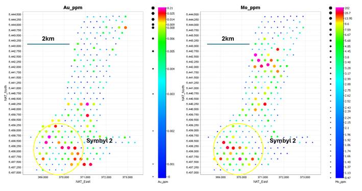
Figure 4 - Soil geochemistry maps of gold (Au) and molybdenum (Mo). Soil spacing is 300m x 300m
Field mapping also identified a series of low sulphidation epithermal ("LSE") gold-sliver veins approximately 5km east of the main Piket alteration corridor. The vein field, which was explored in soviet times, extends over approximately 1.5km x 1.5km and comprises multiple thin gold-silver bearing veins, which are themselves not considered economic but provide an important proof of fertility.
The preservation of low sulphidation epithermal mineralisation confirms that the district has undergone fertile gold-bearing hydrothermal activity and retains preserved upper epithermal levels. This significantly enhances the potential for concealed porphyry systems elsewhere within the broader project area.
The Judzha Project
The Judzha Project was awarded to Discovery Ventures Kazakhstan Ltd on 14 October 2025. Initial mapping showed clearly a very active hydrothermal system with multiple overprinting breccia events including intrusive breccias, hydrothermal breccias and phreatomagmatic breccias. Additionally, there was extensive evidence of sulfides with pyrite preserved on the margins of the system and relic sulfides now overprinted by hematite throughout the core of the system. A small soil sampling campaign was undertaken in November 2025 to determine the extent of mineralisation of the system. Results were received in Q1 2026 and subsequently analysed by East Star and consulting specialist geologists who's combined conclusion was that fertility did not warrant further exploration. The Licence has begun the procedure of being relinquished.
Next Steps
The Company plans to undertake follow-up exploration focused on advancing the Symbyl 2 target area. Initially, this programme is likely to include detailed mapping and systematic sampling of historic trench material and additional rock chip sampling over the defined anomalies.
East Star Resources Plc
Alex Walker, Chief Executive Officer
Tel: +44 (0)20 7390 0234 (via Vigo Consulting)
SI Capital (Corporate Broker)
Nick Emerson
Tel: +44 (0)1483 413 500
Vigo Consulting (Investor Relations)
Ben Simons / Seb Weller
Tel: +44 (0)20 7390 0234
Glossary
Ag | Silver |
Au | Gold |
Bi | Bismuth |
Mo | Molybdenum |
Sn | Tin |
W | Tungsten |
About East Star Resources Plc
East Star Resources is focused on the discovery and development of copper and gold in Kazakhstan. The Company is pursuing multiple exploration strategies including:
· | A joint venture with Hong Kong Xinhai Mining Services Limited to take the Verkhuba Deposit (20.3Mt @ 1.16% copper, 1.54% zinc and 0.27% lead) into production (at no further cost to East Star) with East Star retaining 30% ownership in production |
· | A second VMS Exploration Target with up to 23Mt @ 2.4% copper equivalent in the same region, with numerous other targets being advanced to drill-ready status |
· | A $25 million+ strategic gold exploration joint venture with Endeavour Mining |
· | Tier 1 potential copper porphyry targets and epithermal gold targets in a proven copper porphyry and epithermal belt |
Visit our website:
www.eaststarplc.com
Follow us on social media:
LinkedIn: https://www.linkedin.com/company/east-star-resources/
X: https://x.com/EastStar_PLC
Engage with us by asking questions, watching video summaries and seeing what other shareholders have to say. Navigate to our interactive Investor Hub here: https://eaststarplc.com/link/Pw7j3P
Subscribe to our news alert service: https://eaststarplc.com/regulatory-news
This announcement contains inside information.
The person who arranged for the release of this announcement was Alex Walker, CEO of the Company.
Competent Person Statement
The technical information related to East Star Resources assets contained in this report that relates to Exploration Results is based on information compiled by Mr Christopher van Wijk, who is a Member of the Australasian Institute of Mining and Metallurgy and who is a Geologist employed by East Star Resources as an Executive Director. Mr van Wijk has sufficient experience which is relevant to the style of mineralisation and type of deposit under consideration, and to the activity which he is undertaking, to qualify as a Competent Person as defined in the 2012 Edition of the 'Australasian Code for Reporting of Exploration Results, Mineral Resources and Ore Reserves'. Mr van Wijk consents to the inclusion in the release of the matters based on the information he has compiled in the form and context in which it appears.
This announcement contains inside information for the purposes of Article 7 of Regulation 2014/596/EU which is part of domestic UK law pursuant to the Market Abuse (Amendment) (EU Exit) Regulations (SI 2019/310) ("UK MAR"). Upon the publication of this announcement, this inside information (as defined in UK MAR) is now considered to be in the public domain.
Table 2 - JORC Code, 2012 Edition
Section 1 Sampling Techniques and Data
Criteria | JORC Code explanation | Commentary |
Sampling techniques | · Nature and quality of sampling (e.g. cut channels, random chips, or specific specialised industry standard measurement tools appropriate to the minerals under investigation, such as down hole gamma sondes, or handheld XRF instruments, etc). These examples should not be taken as limiting the broad meaning of sampling. · Include reference to measures taken to ensure sample representivity and the appropriate calibration of any measurement tools or systems used. · Aspects of the determination of mineralisation that are Material to the Public Report. · In cases where 'industry standard' work has been done this would be relatively simple (e.g. 'reverse circulation drilling was used to obtain 1 m samples from which 3 kg was pulverised to produce a 30 g charge for fire assay'). In other cases, more explanation may be required, such as where there is coarse gold that has inherent sampling problems. Unusual commodities or mineralisation types (e.g. submarine nodules) may warrant disclosure of detailed information. | · Systematic soil sampling was completed on a nominal 300m x 300m triangular grid · Samples were collected from approximately 30cm below the ground surface where possible to avoid collecting organic matter. Small stones and debris were removed by hand prior to bagging. · Each sample was described, the location and coordinates noted and entered into EST's database
|
Drilling techniques | · Drill type (e.g. core, reverse circulation, open-hole hammer, rotary air blast, auger, Bangka, sonic, etc) and details (e.g. core diameter, triple or standard tube, depth of diamond tails, face-sampling bit or other type, whether core is oriented and if so, by what method, etc). | · Not applicable |
Drill sample recovery | · Method of recording and assessing core and chip sample recoveries and results assessed. · Measures taken to maximise sample recovery and ensure representative nature of the samples. · Whether a relationship exists between sample recovery and grade and whether sample bias may have occurred due to preferential loss/gain of fine/coarse material. | · Not applicable |
Logging | · Whether core and chip samples have been geologically and geotechnically logged to a level of detail to support appropriate Mineral Resource estimation, mining studies and metallurgical studies. · Whether logging is qualitative or quantitative in nature. Core (or costean, channel, etc) photography. · The total length and percentage of the relevant intersections logged. | · Samples were described by EST geologists into excel datasheets and imported into EST's database · EST's database is maintained by independent contractors Rock Solid in Perth, Australia · Logging is completed visually according to EST procedures.
|
Sub-sampling techniques and sample preparation | · If core, whether cut or sawn and whether quarter, half or all core taken. · If non-core, whether riffled, tube sampled, rotary split, etc and whether sampled wet or dry. · For all sample types, the nature, quality, and appropriateness of the sample preparation technique. · Quality control procedures adopted for all sub-sampling stages to maximise representivity of samples. · Measures taken to ensure that the sampling is representative of the in-situ material collected, including for instance results for field duplicate/second-half sampling. · Whether sample sizes are appropriate to the grain size of the material being sampled. | · Whole samples were submitted. · Samples were collected in sample bags and sent to ALS Ust Kamenogorsk for sample preparation · ALS sample preparation technique involves drying (at >100°C for rocks), fine crushing to 70% passing <2mm, riffle splitting a 250g subsample, and pulverizing to better than 85% passing 75 microns; it is a high-quality, standard method appropriate for geochemistry analysis of drill core, rock, and chip samples to produce homogeneous subsamples · Quality control procedures in at ALS include internal verifications at each size reduction stage to confirm particle size specifications, cleaning equipment with clean rock, silica, and compressed air between samples to prevent carryover, and availability of QC data via Webtrieve™ to maximize sample representivity during sub-sampling · No QA/QC materials were submitted by EST. · Sample sizes were deemed appropriated for the material being sampled · Sample pulps will be returned to EST for long term storage. |
Quality of assay data and laboratory tests | · The nature, quality and appropriateness of the assaying and laboratory procedures used and whether the technique is considered partial or total. · For geophysical tools, spectrometers, handheld XRF instruments, etc, the parameters used in determining the analysis including instrument make and model, reading times, calibrations factors applied and their derivation, etc. · Nature of quality control procedures adopted (e.g. standards, blanks, duplicates, external laboratory checks) and whether acceptable levels of accuracy (i.e. lack of bias) and precision have been established. | · Samples were analysed using the ME-MS61L method. This involves a four-acid digestion (HNO₃-HClO₄-HF-HCl) of a 0.25 g sample aliquot, providing near-total dissolution of most geological materials, followed by ICP-MS multi-element analysis. The method reports up to 50 elements with super-trace detection limits (including Ag, As, Cu, Pb, Zn and other pathfinder elements, gold analyses obtained using AU-ICP21). The accuracy and precision for a wide range of ore and lithogeochemical concentrations is appropriate for the geological exploration of epithermal deposits. · Samples were analysed for gold using the Au-ICP21 method. This involves fire assay fusion of a 30 g sample aliquot with lead collection, cupellation to produce a silver bead, followed by digestion and ICP-AES analysis. The method provides a detection limit of approximately 0.001 ppm Au (1 ppb) with an upper range to 10 ppm. · All samples were analysed using the TRSPEC-20 method. Crushed rejects were analysed using the TerraSpec® 4 HR spectrometer, which collects visible-near infrared to short-wave infrared (VNIR-SWIR) reflectance spectra. Raw spectral data files are produced in ASD format or ASCII format. These spectra enable identification of minerals, particularly those with diagnostic absorption features in the VNIR-SWIR range (e.g., clays, micas, carbonates, sulfates, and many alteration minerals). Data was interpreted by ALS using the spectral geologist (TSG) software. The spectral results were used to support geological characterisation and alteration mapping.
|
Verification of sampling and assaying | · The verification of significant intersections by either independent or alternative company personnel. · The use of twinned holes. · Documentation of primary data, data entry procedures, data verification, data storage (physical and electronic) protocols. · Discuss any adjustment to assay data. | · Not applicable to soil results. |
Location of data points | · Accuracy and quality of surveys used to locate drill holes (collar and down-hole surveys), trenches, mine workings and other locations used in Mineral Resource estimation. · Specification of the grid system used. · Quality and adequacy of topographic control. | · Sample locations were surveyed using handheld GPS. · Grid system WGS84, UTM43N. · Topographic control using SRTM is sufficient for early-stage exploration |
Data spacing and distribution | · Data spacing for reporting of Exploration Results. · Whether the data spacing and distribution is sufficient to establish the degree of geological and grade continuity appropriate for the Mineral Resource and Ore Reserve estimation procedure(s) and classifications applied. · Whether sample compositing has been applied. | · Sampling was completed on a 300 x 300m triangular grid over the whole of the identified lithocap. · Areas outside of this were covered by regolith rendering sampling unrepresentative of bedrock. · Soil samples are not included in Mineral Resource estimation. |
Orientation of data in relation to geological structure | · Whether the orientation of sampling achieves unbiased sampling of possible structures and the extent to which this is known, considering the deposit type. · If the relationship between the drilling orientation and the orientation of key mineralized structures is considered to have introduced a sampling bias, this should be assessed and reported if material. | · Not applicable at this stage of exploration |
Sample security | · The measures taken to ensure sample security. | · Sample security is maintained by East Star geologists until delivered to the ALS laboratory |
Audits or reviews | · The results of any audits or reviews of sampling techniques and data. | · No audits were undertaken for this work. |
Section 2 Reporting of Exploration Results
Criteria | JORC Code explanation | Commentary |
Mineral tenement and land tenure status | · Type, reference name/number, location and ownership including agreements or material issues with third parties such as joint ventures, partnerships, overriding royalties, native title interests, historical sites, wilderness or national park and environmental settings. · The security of the tenure held at the time of reporting along with any known impediments to obtaining a licence to operate in the area. | · The Piket Target is located on exploration license 3720-EL (the "License"). The license was granted in 2025 for an initial period of 6 years with a possibility of further five years extension subject to reduction of the license area by 40%. · East Star owns 100% owns of the license. · East Star resources have servitude for exploration from the local Akim (administrative head), and local landholders, over some areas within the Licence and the license can be explored under these agreements. · There are no known legal or security impediments to obtaining a mining license. |
Exploration done by other parties | · Acknowledgment and appraisal of exploration by other parties. | · At this stage of exploration, no historical exploration programmes are known for the Symbyl Target aside from 1:50,000 scale geology mapping over the area and soviet era trenching.
|
Geology | · Deposit type, geological setting, and style of mineralisation. | · The deposit type being explored is alkalic porphyry Cu-Au and epithermal Au-Ag.
|
Drill hole Information | · A summary of all information material to the understanding of the exploration results including a tabulation of the following information for all Material drill holes: o easting and northing of the drill hole collar o elevation or RL (Reduced Level - elevation above sea level in metres) of the drill hole collar o dip and azimuth of the hole o down hole length and interception depth o hole length. · If the exclusion of this information is justified on the basis that the information is not Material and this exclusion does not detract from the understanding of the report, the Competent Person should clearly explain why this is the case. | · Not applicable, no drilling reported. |
Data aggregation methods | · In reporting Exploration Results, weighting averaging techniques, maximum and/or minimum grade truncations (e.g. cutting of high grades) and cut-off grades are usually Material and should be stated. · Where aggregate intercepts incorporate short lengths of high-grade results and longer lengths of low-grade results, the procedure used for such aggregation should be stated and some typical examples of such aggregations should be shown in detail. · The assumptions used for any reporting of metal equivalent values should be clearly stated. | · Not applicable, all soil results reported. |
Relationship between mineralisation widths and intercept lengths | · These relationships are particularly important in the reporting of Exploration Results. · If the geometry of the mineralisation with respect to the drill hole angle is known, its nature should be reported. · If it is not known and only the down hole lengths are reported, there should be a clear statement to this effect (e.g. 'down hole length, true width not known'). | · Not applicable |
Diagrams | · Appropriate maps and sections (with scales) and tabulations of intercepts should be included for any significant discovery being reported These should include but not be limited to a plan view of drill hole collar locations and appropriate sectional views. | · Relevant diagrams have been included in the body text. |
Balanced reporting | · Where comprehensive reporting of all Exploration Results is not practical, representative reporting of both low and high grades and/or widths should be practiced to avoid misleading reporting of Exploration Results. | · All soil samples have been reported. |
Other substantive exploration data | · Other exploration data, if meaningful and material, should be reported including (but not limited to): geological observations; geophysical survey results; geochemical survey results; bulk samples - size and method of treatment; metallurgical test results; bulk density, groundwater, geotechnical and rock characteristics; potential deleterious or contaminating substances. | · Not applicable. |
Further work | · The nature and scale of planned further work (e.g. tests for lateral extensions or depth extensions or large-scale step-out drilling). · Diagrams clearly highlighting the areas of possible extensions, including the main geological interpretations and future drilling areas, provided this information is not commercially sensitive. | · East star is planning to undertake systematic sampling and detailed mapping as a next step.
|
Related Shares:
East Star Reso