22nd Apr 2026 07:00

THIS ANNOUNCEMENT CONTAINS INSIDE INFORMATION FOR THE PURPOSES OF ARTICLE 7 OF THE MARKET ABUSE REGULATION (596/2014/EU) AS THE SAME HAS BEEN RETAINED IN UK LAW AS AMENDED BY THE MARKET ABUSE (AMENDMENT) (EU EXIT) REGULATIONS (SI 2019/310). UPON THE PUBLICATION OF THIS ANNOUNCEMENT, THIS INSIDE INFORMATION IS NOW CONSIDERED TO BE IN THE PUBLIC DOMAIN.
Trading Symbols
AIM: UFO FWB: I3A1
22 April 2026
Alien Metals Limited
("Alien" or the "Company")
2.79 Moz Silver Mineral Resource Estimate at Elizabeth Hill
Alien Metals Limited (AIM: UFO), a minerals exploration and development company, advises that its joint venture partner, West Coast Silver Limited ("West Coast Silver") (ASX: WCE), has today released an inaugural Mineral Resource Estimate ("MRE") for the Elizabeth Hill Silver Project in the West Pilbara, Western Australia (the "Elizabeth Hill Project").
West Coast Silver has reported a JORC (2012) compliant MRE of 2.79 Moz silver at 617 g/t Ag, comprising 0.37 Moz Indicated and 2.42 Moz Inferred, reported above a 20 g/t Ag cut-off, confirming Elizabeth Hill as one of Australia's highest-grade silver deposits and establishing a strong foundation for near-term growth and potential development.
Direct Leverage to Resource Growth
Alien retains a 30% interest in the Elizabeth Hill Project and holds 30.5 million shares in West Coast Silver (representing an 8.7% interest in the issued share capital of West Coast Silver), providing exposure to both project-level value creation and also its equity shareholding in West Coast Silver.
The newly defined resource represents a significant milestone for the Elizabeth Hill Silver Project, a proven high-grade silver system with historical production of approximately 1.2 Moz , which is located on a granted mining lease with existing infrastructure nearby. The current resource footprint remains open at depth and along strike, reinforcing the potential for scale.
Executive Chairman, Bruce Garlick, commented:
"The delivery of a maiden 2.79 Moz silver resource is a major achievement and reinforces the Elizabeth Hill Project's position as one of Australia's premier high-grade silver assets.
"Through its 30% project interest and strategic equity holding in West Coast Silver, Alien is well positioned to capture value from ongoing resource growth and project advancement, offering shareholders meaningful leverage to future success."
The full release issued by West Coast Silver is provided below in Appendix A.
For further information, please visit the Company's website at www.alienmetals.uk or contact:
Alien Metals Limited
Bruce Garlick
Email: [email protected]
Strand Hanson (Financial and Nominated Adviser)
James Harris / James Dance / Edward Foulkes
Tel: +44 (0) 207 409 3494
Zeus Capital Limited (Joint Broker)
Harry Ansell / Katy Mitchell Tel +44 (0) 203 829 5000
Turner Pope (Joint Broker)
Andy Thacker / Guy McDougall
Tel: +44 (0) 203 657 0050
Notes to Editors
Alien Metals Ltd is a mining exploration and development company listed on the AIM market of the London Stock Exchange (AIM: UFO). The Company follows a balanced strategy of advancing and strengthening its asset portfolio through targeted technical work and project development, while evaluating partnerships, joint ventures, and selective monetisation opportunities that are value-enhancing for shareholders. At the same time, Alien will continue to consider opportunities to expand our asset base through carefully selected acquisition opportunities which meet the Board's prudent criteria.
Alien's principal focus is the advancement and development of its 90%-owned Hancock Iron Ore Project in the central Pilbara region of Western Australia. The Hancock tenements contain a JORC-compliant resource of 8.4Mt at 60% Fe and offer significant exploration upside, which is targeted to deliver a mining operation of 2Mtpa for 10 years. The Project benefits from direct access to the Great Northern Highway, providing a route to export facilities at Port Hedland, one of the world's largest iron ore export hubs. Alien also holds exploration interests in the Brockman and Vivash iron ore projects in the West Pilbara.
Alien additionally retains exposure to two advanced precious and base metal assets in the Pilbara. At Munni Munni, one of Australia's largest PGM systems hosting a historic resource of 2.2Moz PGM (Palladium, Platinum, and Rhodium) and gold, the Company has completed its partial asset sale and joint venture transaction with GreenTech Metals Ltd, under which Alien has divested a 70% interest in the Munni Munni tenements to GreenTech and Alien will retain a 30% interest, free carried to the completion of a bankable feasibility study at Munni Munni. Alien (via wholly owned subsidiary A.C.N. 643 478 371 Pty Ltd) also retains a 30% interest in the Elizabeth Hill Silver Project through a joint venture with Crest, which encompasses the Elizabeth Hill Mining Lease M47/342, which has produced some of Australia's highest-grade silver ore during the late 1990s. Alien retains a 30% interest in the Elizabeth Hill Silver Project and additionally holds 30.5 million shares in West Coast Silver Limited, providing both direct project exposure and equity participation in ongoing development.
Competent Person's Statement
The information in this Report that relates to the current Mineral Resource estimate is based on, and fairly reflects, information compiled by Mr Phil Jankowski. Mr Jankowski is a full-time employee of ERM and is a Fellow of the Australasian Institute of Mining and Metallurgy. Mr Jankowski has sufficient experience relevant to the style of mineralisation and type of deposit under consideration and to the activity which he is undertaking to qualify as Competent Person as defined in the 2012 Edition of the Australasian Code for the Reporting of Exploration Results, Mineral Resources and Ore Reserves (JORC Code). Mr Jankowski consent to the disclosure of the information in this Report in the form and context in which it appears.
Appendix A - WCE ASX Release Titled "Elizabeth Hill Silver Project - 2.8 Moz Silver Mineral Resource Estimate" dated 22 April 2026
Elizabeth Hill Silver Project - 2.8 Moz Silver Mineral Resource Estimate
· West Coast Silver announces its inaugural Mineral Resource Estimate (MRE) for the Elizabeth Hill Silver Project, Western Australia.
· 2.79 Moz Silver from 141,000t at 617g/t Ag, including 369,000 oz Indicated and 2.42 Moz Inferred, reported above a 20 g/t Ag cut-off.
· Establishes Elizabeth Hill as one of Australia's highest-grade silver deposits.
· Pit optimisation confirms Reasonable Prospects for Eventual Economic Extraction (RPEEE) within a compact open pit (~200 m x 180 m, 130 m deep) on a granted Mining Lease.
· Optimised pit captures almost all current mineralisation, including historical underground areas.
· The consensus metal prices used to define the open pit optimisation capture almost the entirety of the current mineralisation, including mining around the previous Elizabeth Hill underground operation.
· Mineralisation remains open along strike and at depth, with significant upside from near-mine and regional targets.
· MRE represents a foundation inventory, with clear potential for growth through ongoing drilling and geophysics across a ~180 km² land package
West Coast Silver Limited (ASX: WCE) ('West Coast Silver' or the 'Company') is pleased to announce the results of the inaugural Mineral Resource estimate (MRE) at the Elizabeth Hill Silver Project in Western Australia.
The MRE establishes a robust, high-grade foundation that will support continued development throughout 2026, paving the way for additional economic studies.
Commenting on the Mineral Resource Estimate (MRE), Executive Chairman Bruce Garlick said:
"West Coast Silver has progressed exploration at Elizabeth Hill rapidly to deliver a JORC 2012 compliant inaugural Inferred and Indicated Mineral Resource Estimate of 2.79 Moz Ag from 141,000 t at a grade of 617 g/t Ag above a cut-off grade of 20 g/t Ag. The inaugural MRE includes successful drilling results from 2025 exploration and an accurate depletion of ore mined between 1999 and 2000.
The MRE grade confirms Elizabeth Hill as one of the highest-grade silver projects in Australia. At a cut-off grade of 60 g/t, the resource contains over 2.72 Moz Ag from 76,000t @ over 1,114 g/t Ag. This is 97% of total MRE silver ounces and 54% of total MRE tonnes. The pit optimisation extends to the limits of most drilling and includes historical areas mined from underground. This speaks to the robustness of the deposit and the growth opportunities remaining at depth, along strike, and peripheral to existing mineralisation.
As 40% of MRE tonnes and 86% of silver ounces remain in the Inferred category, there is opportunity to significantly grow the MRE by further drilling within the open pit optimisation to convert Inferred resources to Indicated resource status.
This first Elizabeth Hill MRE is a benchmark for what is expected to be a continued high grade Ag growth story leading to the development of Australia's highest-grade silver mine."
2026 Mineral Resource Estimate
The 2026 Mineral Resource Estimate (MRE) has been completed in collaboration with mineral resource industry consulting firm ERM Australia Consultants Pty Ltd (ERM).
The Elizabeth Hill Silver Project is located 45 km south of Karratha, WA, on mining lease M47/342, held 70% by Crest Silver (West Coast Silver Ltd) and 30% by Alien Metals subsidiaries (Figure 1). The lease covers part of the Munni Munni Intrusive Complex, with silver mineralisation structurally controlled by the Munni Munni Fault and hosted in altered ultramafic and granite rocks within 50 m of the fault, with most mineralisation within 10 m. Silver is closely linked to silica-carbonate veining, forming high-grade, nuggetty native silver, mainly in ultramafic rocks.
In 2025, Errawarra Resources (now West Coast Silver) acquired 70% of the Elizabeth Hill Project after completing three drilling programs.
Mineralisation contains restricted, ultra-high-grade veins of native silver. An example of the ultra-high grades is the Karratha Queen silver specimen on display within the Perth Mint which contains 3,250 oz of Ag recovered from previous underground mining at Elizabeth Hill between 1999 and 2000. These veins are known to occur in structurally controlled shoots with dimensions not exceeding 5 m. For modelling, two domains were created. The first domain, using a cut-off of 20 g/t Ag, was chosen to define the outer limit of mineralisation. A second 5,000 g/t Ag high-grade domain was then modelled around mined historic high-grade underground stopes.
Inside the 20 g/t Ag domain, 1,150 g/t Ag and 13,000 g/t Ag were selected as cut-offs for high-grade indicators. Inside the 5,000 g/t Ag domain a 13,000 g/t Ag indicator was selected for the high-grade indicator.
For each domain, the proportion and grade were estimated by ordinary kriging; the final block grade is the weighted average of the proportion and grade estimated for each of the blocks.
A reconciliation was completed between previous production and the estimated model. The reconciliation showed that inside the mined stope the model has 102% of the tonnes at 126% of the grade compared with production. The recorded grade is the recovered grade and the amount of silver discharged to tailings is not well documented.
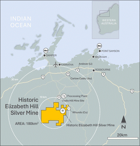
Figure 1: Elizabeth Hill Exploration Tenement Package and Mine Location
The Mineral Resource estimate is detailed in Table 1.
Table 1: Elizabeth Hill Mineral Resource estimate
JORC Classification | Tonnes (kt) | Ag (g/t) | Ag (koz) |
Indicated | 84 | 137 | 369 |
Inferred | 57 | 1,331 | 2,426 |
Total | 141 | 617 | 2,795 |
Notes to the Mineral Resource:
1. The tonnes and grades have been reported inside a pit shell.
2. The Mineral Resource is reported in accordance with the JORC Code 2012 Edition.
3. The Competent Person for the Mineral Resource is Phil Jankowski FAusIMM of ERM.
4. Mineral Resources are reported at a cut-off of 20 g/t Ag, constrained by an optimised open pit generated at A$85.71/oz Ag.
5. Rounding may lead to minor apparent discrepancies.
Open Pit Optimisation Parameters
A pit optimisation using Whittle software implementation of the Lerch-Grossman algorithm was completed to evaluate reasonable prospects for eventual economic extraction (RPEEE). Optimisation considered the potential of using standard open pit mining techniques, with a processing flowsheet of gravity-Merrill Crowe cyanidation-flotation. A metal price of $US60/oz Ag was used; other costs and physical inputs (Table 2) are based on ERM's experience and are reasonable for the scale of the mineralisation. Based on the parameters adopted, the cut-off grade is 20.8 g/t Ag, which for reporting has been rounded to 20 g/t Ag.
Table 2: Open pit optimisation parameters
Parameter | Units | Value |
Silver Price | $US/oz | 60 |
USD/AUD Exchange Rate | Ratio | 0.70 |
Silver Price | $AU/oz | 85.71 |
Royalty | % of production | 5% |
Mining cost | $AU/t | 4.50 |
Mining Dilution | % of insitu tonnes | 5% |
Mining Recovery | % of insitu tonnes | 5% |
Payability | % of production | 99% |
Processing cost | $A/t of plant feed | 45.57 |
General and Administrative cost | $A/t of plant feed | 3.00 |
Metallurgical recovery | % of head grade | 90 |
Overall pit slope angle | Degrees | 46 |
Table 3: Elizabeth Hill MRE by JORC classification grade tonnage table
Indicated | Inferred | Total | |||||||
Cut-off | Tonnes | Ag (g/t) | Ag (oz) | Tonnes | Ag (g/t) | Ag (oz) | Tonnes | Ag (g/t) | Ag (oz) |
0 | 118,907 | 100 | 382,159 | 80,563 | 940 | 2,435,318 | 199,469 | 439 | 2,817,482 |
20 | 84,117 | 137 | 369,248 | 56,696 | 1,331 | 2,426,218 | 140,812 | 617 | 2,795,472 |
40 | 49,694 | 211 | 336,988 | 41,823 | 1,795 | 2,413,261 | 91,516 | 935 | 2,750,255 |
60 | 35,551 | 275 | 314,030 | 40,522 | 1,851 | 2,411,311 | 76,072 | 1,114 | 2,725,347 |
80 | 30,795 | 306 | 303,291 | 38,353 | 1,952 | 2,406,597 | 69,147 | 1,219 | 2,709,894 |
100 | 23,782 | 369 | 282,439 | 37,200 | 2,010 | 2,403,500 | 60,982 | 1,370 | 2,685,947 |
The optimal open pit has a footprint of approximately 200 m by 180 m and a maximum depth of 130 m, reaching -15 m RL. It captures almost the entirety of the current mineralisation, including mineralisation around the previous underground operation. The mineralisation is insufficiently tested below the pit shell. Additional lodes, especially high-grade material down plunge and down dip, may produce a significant increase in the size of an optimal resource reporting pit.
Views of the optimized pit and resource block model coloured by classification are presented in Figure 2 to Figure 4.
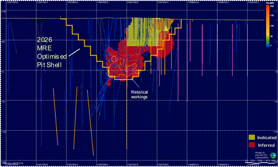
Figure 2: Long section view of block model with pit shell shown. Yellow=Indicated, Red=Inferred; Orange traces show planned and current diamond holes and pink traces show planned and current RC holes.
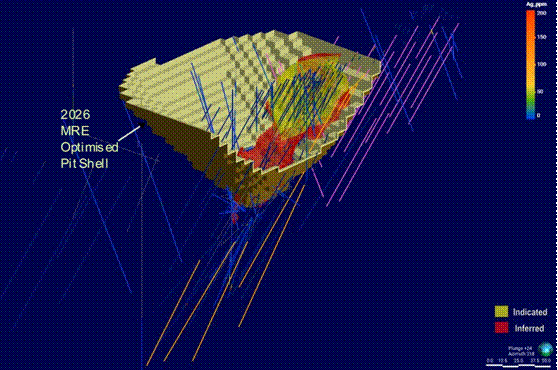
Figure 3: View from southeast of model > 20 g/t Ag with pit shell. Yellow=Indicated Red=Inferred; Orange traces show planned and current diamond holes and pink traces show planned and current RC holes; .pit wall sliced for clarity.
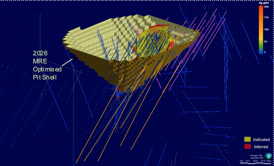
Figure 4: View from southeast of model > 20 g/t Ag with pit shell. Yellow=Indicated, Red=Inferred; Orange traces show planned and current diamond holes and pink traces show planned and current RC holes.
Listing Rule 5.8.1 Disclosure
Geology and Geological Interpretation
M47/342 covers part of the ultramafic basal portion of the Munni Munni Intrusive Complex (MMIC) of the Sisters Supersuite, that intrudes granitoids of the Cherratta Granitoid Complex.
A local geology map and schematic long section are presented in Figure 5 and Figure 6 respectively.
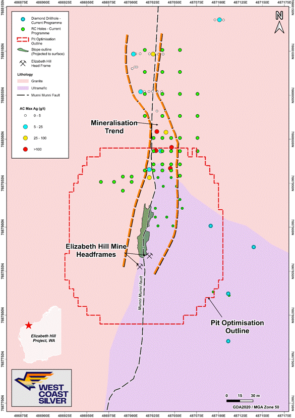
Figure 5: Plan View Elizabeth Hill MRE open pit optimisation outline over geology, 2025 aircore drilling results, 2026 planned diamond and RC exploration drill collars and historic underground mined area projected to surface.
Source: WCE ASX Announcement dated 24 February 2026 (modified)
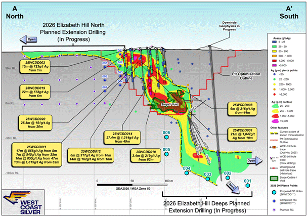
Figure 6: Schematic Longitudinal Section, Elizabeth Hill Mine showing 2026 MRE optimised pit shell, historical workings mineralisation grade distribution, planned 2026 RC and Diamond extension drilling (in progress).
Note. Longitudinal Section is a rendition of the interpreted Munni Munni Fault surface between granite rocks (west of sectional view) and the basal ultramafic lithologies of the MMIC (east of sectional view).
Source: WCE ASX Announcement dated 14 April 2026 (modified).
The MMIC is a complex layered ultramafic-mafic intrusion, with layers of dunite, lherzolite wehrlite olivine websterite, clinopyroxenite and websterite within the ultramafic zone. The general stratigraphy of the MMIC comprises an upper 3,630 m thick, generally massive Gabbroic Zone and a lower 1,850 m thick, layered Ultramafic Zone which dip moderately to the south. Within the project area, the MMIC comprises variations on pyroxenitic to peridotitic units of the lowermost Ultramafic Zone.
Foliated granite to granodiorite is a widespread component of the Cherratta Granitoid Complex, particularly around the MMIC. Additionally, various granitoids that have intruded the Whundo Group are included within the unit. The rock is locally k-feldspar porphyritic and weakly banded.
Primary igneous intrusive contacts between the MMIC Ultramafic Zone and the underlying footwall to the intrusive CGC are exposed northeast of the Elizabeth Hill mine and interpreted to plunge moderately south.
Silver mineralisation at Elizabeth Hill is structurally controlled and has a clear spatial and genetic association with the subvertical north-trending Munni Munni Fault. All the silver is hosted in fractured, veined, metasomatised and/or broken ultramafic and granite within 50 m either side of the fault, most within 10 m of the fault. The fault intersects the plunging granite-ultramafic intrusive contact at a high angle and offsets that contact several hundred metres, with an apparent east side down and lateral sinistral movement.
In cross section, the silver mineralisation is apparently controlled and localised around a flexure in the Munni Munni Fault with localised splays along structures and the granite-ultramafic contact away from the fault. Detailed modelling (ongoing) of the granite-ultramafic contact in the vicinity of the mine indicates a region of complicated geometry on that contact that most likely represents complex fault interactions with multiple fault planes anastomosing and intersecting.
The great majority of mineralisation is localised in structure that juxtaposes ultramafic against granite. Granite-granite juxtaposition on either side of the fault has only relatively minor silver mineralisation. However, this remains an area of active current exploration and previous conclusions may be influenced by exploration that has concentrated solely on that granite-ultramafic association, without examining possibilities beyond that relationship.
Within the mineralised zone, silver is intimately associated with silica-carbonate veining and alteration. High grade silver mineralisation often forms nuggetty networks of native silver adjacent to areas of intense carbonate veining in both ultramafic (dominantly) and granite (subordinately).
Several alteration types are recognised associated with the mineralised zones. These include:
· Breccias with both pyroxenite and granite/gneiss clasts
· Silica or calcite matrix
· Intense silicification in and around the Munni Munni Fault
· Completely silicified zones
· Quartz and calcite veins.
These zones within the fault area are often overprinted by later brittle fracturing deformation, most likely resulting from reactivation of the fault as a brittle fracture zone post-dating mineralisation.
Weathering is variably developed and ranges from subcrop of fresh rock at surface to penetration of oxidation and clayey alteration up to 30 m depth, typically associated with intense late brittle fracturing.
Drilling Techniques
A total of 1,602 drillholes for 17,405.9 m have been completed in the project area, as detail in Table 4. Most of the drilling meterage is from Diamond Drilling (DD) and Reverse Circulation (RC) drillholes.
Table 4: Summary of drilling history
Year(s) | No. of holes | Hole Type | Metres |
1987 | 11 | RC | 805 |
1989 | 1 | DD | 12.9 |
8 | RAB | 187.5 | |
2 | RC | 147 | |
6 | RCD | 656.25 | |
1999 | 8 | DD | 102.4 |
2000 | 10 | DD | 138.1 |
47 | RC | 2,419 | |
693 | SL | 1,545.1 | |
314 | FC | 526.95 | |
2001 | 9 | DD | 392.6 |
2002 | 22 | RC | 2,367 |
2010 | 1 | RC | 180 |
2021 | 4 | DD | 213.2 |
1 | TR | 47 | |
2022 | 3 | RC | 313 |
2025 | 6 | AC | 70 |
25 | DD | 2,186.05 | |
Absent | 78 | DD | 1,222.8 |
313 | FC | 525.55 | |
40 | RC | 3,348.5 | |
TOTAL | 1,602 |
| 17,405.9 |
Sampling and Sub-sampling techniques
Historic Drilling
Alien Metals Drilling 2021-24
All RC samples are put through a cone splitter, and the sample was collected in a unique pre-numbered calico sample bag. The moisture content of each sample was recorded in the database.
The RC samples are sorted, oven dried, the entire sample is pulverised in a one stage process to 85% passing 75 µm. The bulk pulverised sample was then bagged and approximately 200 g extracted by spatula to a numbered paper bag that was used for the assay charge.
The DD samples were cut in half, and the right half of the core was submitted for assay. They are oven dried, jaw crushed to nominal <10 mm, 3.5 kg was obtained by riffle splitting and the remainder of the coarse reject was bagged while the 3.5 kg was pulverised in a one stage process to 85% passing 75 µm. The bulk pulverized sample was then bagged and approximately 200 g extracted by spatula to a numbered paper bag that was for the assay charge.
For some RC drilling, typically in areas where the geologist decides that there is no mineralisation, 4 m composite samples were taken and used for assay. The RC drill spoil samples were collected by traversing each sample pile systematically by scoop to obtain similar volumes of representative material for the nominated composite interval. This is regarded as a fit for purpose sampling regime for the type of drilling and the current stage of exploration.
Field duplicate RC sampling was also undertaken with the drillers collected a duplicate sample, at the same time as the main sample, off the second sample port on the cone splitter or re-splitting of the reject interval if using a riffle splitter.
The samples were then sent to Bureau Veritas Laboratory for sample preparation and analysis. At the laboratory, the samples were sorted and discrepancies to documentation notified to the Company, oven dried, crushed to -10 mm for core samples, riffle split if oversize and the bulk reject was retained. The sample was then pulverised in a vibrating disc pulveriser in a single step to 95% passing 105 µm, a ~200 g was split off and bagged for analysis and the bulk reject was retained. The sample sizes are appropriate for the geology and style of mineralisation being investigated.
Pre-2021 Historical Drilling
Various sampling methods have been employed previously for non-core drilling. Information is available for some anomalous drill holes discussed in this report. Samples for drill hole AG43 have been riffle split and spear sampled from drill spoils.
The CP cannot confirm but expects the core was cut and sampled according to industry standard (half core) techniques. Information on sample moisture content is available for some drilling. Where available most samples were dry.
Sample sizes have not been described in historical reports.
WCE Drilling 2024-present
Diamond Drilling
Samples for laboratory analyses were taken by sawing the DD core in half along a cutting line, which is offset from the core orientation line. The half of the drill core without the orientation line was collected for assaying. Duplicate samples were collected by sawing the remaining half core into two quarter cores, taking a quarter core but preserving the quarter core with the orientation line. Original and QAQC samples (standards, blanks and core duplicates) were sent to the laboratory for analysis (ALS Perth for all elements and secondary assaying at ALS Langley Canada for any over grade Ag assays).
DD core samples were fine crushed (CRU-42a) to 90% passing 3.15 mm. The sample was then rotary split directly from the crusher (SPL-22a) and pulverised to obtain 750 g to 85% passing 75 µm (method PUL-25e). These preparation methods are standard and appropriate for the samples.
The 1 m half core samples are appropriate to the grain size of the material being sampled. Where intervals of native silver were logged, these were sampled to mineralogical boundaries as low as 0.2 m in length.
Air Core Drilling
A hydraulic rotary sample splitter on the aircore rig was used to obtain a representative 2 kg - 3 kg sample of every metre drilled in a pre-numbered calico bag.
Based on geological logging, selected 1m samples were collected per hole for silver assaying, as part of a 48-element suite, with the remainder of the 1 m samples secured as back up to any composite samples collected in the same hole. If a hole was partially or not sampled on a 1 m basis, the rest of the hole was sampled as 2 m or 3 m composites.
All sampling excluded the transported cover rocks.
When compositing, a uniquely numbered calico bag was used, and the sample was collected by using a scoop through the sample pile to ensure the sample was as representative as possible.
One metre, and two and three metre composite samples were sent to the ALS Geochemistry laboratory in Perth for analysis of 48 elements, including Ag, by method ME-MS61L.
Samples were oven dried as required, fine crushed to 90% passing 3.15 mm, pulverised, and split to obtain a nominal 500 g sub sample for assaying. The remainder of the sample was to be retained as a coarse reject.
Certified Reference Material (CRM) standards (OREAS 608b & 611b), and blanks were inserted approximately every 25 and 50 samples, respectively. No field duplicates were collected as the drilling was deemed reconnaissance in nature.
The 2 kg - 3 kg sample size is considered appropriate for the material being sampled.
Sample Analysis Method
Historic Drilling
Alien Metals Drilling 2021-24
Assaying was completed by Bureau Veritas Laboratory in Perth, an accredited commercial laboratory. All sample results have been received.
For both RC and DD drilling samples, appropriate commercial CRM standards, blanks and field duplicates were submitted at the rate of around 5% of all samples.
An aliquot of sample was fused with Sodium Peroxide, and the melt was dissolved in dilute hydrochloric acid and the solution analysed via Inductively Coupled plasma (ICP) Mass Spectrometry (MS). The detection limit for Ag was 5 g/t Ag.
As part of normal procedures, Alien examined all standards and blanks to ensure that they are within tolerances. Additionally, sample size, grind size and field duplicate results are examined to ensure no bias to silver grade exists.
Pre-2021 Historical Drilling
Assaying and laboratory procedures are not available for most historical drilling. However, this information is available for some of the drill holes described in this report.
Samples were sent to Genalysis Laboratories for analysis of Ag only by a two-acid (perchloric/hydrochloric) digest with atomic absorption spectrometry (AAS) finish (lab code C/AAS) to a detection limit of 1 g/t Ag.
Some drill samples of each batch were check assayed at Genalysis and Ultra Trace Laboratories by an accelerated cyanide leach with an AAS finish (lab code Leachwell/AAS) to a detection limit of 1 g/t Ag.
Some samples of each batch were also analysed by Genalysis for Ag only by an Aqua Regia digest with an AAS finish (lab code B/AAS) to a detection limit of 0.1 g/t Ag. The tenor of results from different analytical techniques and different laboratories was generally comparable. The Competent Person (CP) could not independently verify the QA/QC of these analyses.
C/AAS is considered a partial extraction.
West Coast Silver has completed sufficient verification of the assay data, and in the CP's opinion it provides sufficient confidence the assaying was appropriate for the mineralisation present and is fit for purpose.
None of the previous reports that have been reviewed by West Coast Silver to date specified the use of any spectrometers or handheld XRF tools.
Information on sample preparation and QA procedures is not available for most drilling.
WCE Drilling 2024-present
Diamond Drilling
Laboratory samples were analysed at ALS laboratories (Perth) for 48 elements, four acid digestion and ICP-MS finish. Samples with above upper detection limit analyses (>100 g/t Ag) were then analysed at ALS Perth with Ag-OG62 (four acid, ore grade Ag), ME-OG62 (four acid ore grade elements), Pb-OG62 (ore grade Pb - four acid) and Zn-OG62 (ore grade Zn - four acid). For Ag assays >1,500g/t Ag, samples were sent to ALS Langley (Canada) for analysis by Ag-GRA21 (Ag 30g FA-GRAV finish). For Ag assays >10,000 g/t, samples were then further analysed at ALS Langley by Ag-CON01 (Ag concentrate).
Four acid digestion is considered near total digestion.
The first samples analysed at the start of each hole were a blank then a standard before assaying of core samples, then ending the sample run for the hole with a standard then a blank.
CRM standards (OREAS 303b, OREAS-602c, OREAS-608b, OREAS-611b) were inserted in the sampling stream as every 25th sample. Duplicate samples (quarter core) were collected as every 50th sample. Irrespective of where intervals of native silver were sampled in the hole, a duplicate sample was collected which was followed by insertion of a blank.
Acceptable levels of accuracy and precision have been established for all CRM standards and for the majority of the blank material.
Four blanks which had been inserted after core intervals with visible native silver showed some contamination of the blanks from the previous extremely high-grade Ag sample of <1% relative as carry-over from the crusher and pulveriser. The CP considers the levels of carry-over is acceptable and there was no direct evidence of further contamination after the blank on succeeding samples.
Air Core Drilling
Laboratory samples were analysed at ALS laboratories (Perth) for 48 elements, four acid digestion and ICP-MS finish. Samples with above upper detection limit analyses (>100 g/t Ag) were then analysed at ALS Perth with Ag-OG62 (four acid, ore grade Ag), ME-OG62 (four acid ore grade elements). For Ag assays >1,500 g/t Ag, samples were sent to ALS Langley (Canada) for analysis by Ag-GRA21 (Ag 30 g FA-GRAV finish).
A 0.25 g split of the samples were analysed with the ALS ME-MS61L method that provides ALS's lowest detection levels (0.002 g/t for Ag) from a four-acid digestion with 48 elements determined by ICP-MS.
ME-MS61L is considered a near total digestion.
Standards and blanks were inserted in the sampling sequence for analysis with the ME method.
Acceptable levels of accuracy and precision have been established for all CRM standards and for all but one of the blank materials.
Aircore assays are regional geochemical results that are used to identify areas for further follow up exploration, and anomalies identified generally consist of several elevated samples. The CP notes minor carry-over contamination in one blank sample from the pulveriser or crusher does not affect anomaly identification.
Mineral Resource Estimate and Classification
Silver mineralisation domains were modelled using Leapfrog Geo. Given the very high variability of mineralisation, and the known occurrence of extreme grades, it was recognised that multiple domains would be required.
For the domaining exercise, all available data was used. To supplement the drilling and sampling data, a grid of flat lying pseudo-drillholes on a 5 m by 5 m grid was created and intersected with the historic stope. These intersections were used to supplement the intersections of drillholes, and in places expand the outer contact to ensure the mineralised domain captures all the stope.
In each domain, the domained composite datasets are highly skewed, with high coefficient of variance and maxima in the percentage range. This is a result of the presence of small, extreme grade structures that could not be either effectively sampled by the drilling grid or sub-domained.
An indicator approach for grade interpolation was used to restrict the influence of the high-grade Ag composites. For the 20 g/t Ag domain the following approach was adopted:
• Estimate the proportion (IND2) of each block between ≥ 1150 g/t Ag and < 13,000 g/t Ag by indicator kriging, the proportion will be between 0 and 1.
• Estimate the proportion (IND3) of each block ≥ 13,000 g/t Ag by indicator kriging, the proportion will be between 0 and 1.
• The proportion (IND1) of each block < 1150 g/t Ag will be IND1 = 1 - IND2 -IND3.
Grades for domain 20 g/t Ag domain were interpolated in three bins:
• Bin 1 (AG1) only used composite grades < 1150 g/t Ag.
• Bin 2 (AG2) only used composite grades between ≥ 1150 g/t Ag and < 13,000 g/t Ag.
• Bin 3 (AG3) only used composite grades ≥ 13,000 g/t Ag.
The final grade (AG_PPM), a weighted average for each block is then calculated by the following formula:
• AG_PPM = (IND1 * AG1) + (IND2 * AG2) + (IND3 * AG3)
A similar approach was used for the 5,000 g/t Ag domain:
• Estimate the proportion (IND5) of each block ≥ 13,000 g/t Ag by indicator kriging, the proportion will be between 0 and 1.
• The proportion (IND4) of each block < 13,000 g/t Ag will be IND4 = 1 - IND5.
Grades for domain the 5,000 g/t Ag domain were interpolated in two bins:
• Bin 4 (AG4) only used composite grades < 13,000 g/t Ag.
• Bin 5 (AG5) only used composite grades ≥ 13,000 g/t Ag.
The final grade (AG_PPM), a weighted average for each block is then calculated by the following formula:
• AG_PPM = (IND4 * AG4) + (IND5 * AG5)
Validation of grade estimates was completed by:
• Manual check of order relations with no issues identified
• Visual checks on screen in cross section and plan view to ensure that block model grades honour the grade of the composites
• Statistical comparison of composite and block grades
• Generation of swath plots to compare input and output grades in a semi-local sense, by easting, northing and elevation
• Reconciliation of the previously mined stope with the current block model.
Drilling produced a coherent, geologically plausible interpretation of the mineralisation that matches the known controls.
The QAQC data available for the recent data demonstrates it is of acceptable quality, being reasonably accurate and precise and fit for purpose of estimating the Mineral Resource.
The comparison between the model prediction and the production records is reasonable, with the caveat that the production records are suspected of being incomplete and do not account for the Ag discharged to tailings.
Previous mining has demonstrated that the mineralisation was able to be mined from a selective underground operation; less selective open pit mining is therefore highly likely to be able to define and extract mineralisation at the calculated economic cut-off of 20 g/t Ag.
In the resource dataset, there is a relatively dense grid of recent surface RC and diamond drillholes in the upper, northern lobe; in the deeper southern lobe the majority of the available data comprises underground diamond drilling, face and channel samples, and sludge holes. To reproduce the shape of the mineralisation as demonstrated by the previous stopes, it was necessary to use the grades from this data; however the quality of the sampling from face samples and sludge drilling is not generally suitable for resource estimation.
A distance buffer of 7.5 m from the existing drill data in the upper part of the mineralisation was used to classify Indicated; other blocks were classified Inferred.
Grade Cut-off Parameters
Based on the parameters outlined in the Mining Factors and Assumptions used in pit optimisation, the calculated cut-off grade is 20.8 g/t Ag, which for reporting purposes has been rounded to 20 g/t Ag.
Mining and Metallurgical Methods and Parameters
A pit optimisation was completed to demonstrate reasonable prospects for eventual economic extraction (RPEEE). Optimisation considered the potential of using Gravity - Merrill Crow - Flotation processing with assumed costs of:
• Silver price of A$85.71 (US$60 at AUD/USD exchange rate of 0.70)
• Royalty of 5%
• Payability of 99%
• Mining cost of A$4.5/t of rock
• Mining dilution of 5%
• Mining recovery of 95%
• Processing cost of A$45.57/t of feed
• General and Administrative cost - A$3/t of feed
• Processing recovery - 90%
• Overall pit slope angle - 46 degrees.
Based on the parameters outlined above, the calculated cut-off grade is 20.8 g/t Ag, which for reporting purposes has been rounded to 20 g/t Ag.
Previous production at Elizabeth Hill utilised a gravity circuit. Historical recovery data is not available. A processing flowsheet of gravity-Merrill Crowe cyanidation-flotation was considered for the pit optimisation with an assumed recovery of 90%.
Elizabeth Hill Silver Project
Elizabeth Hill is one of Australia's high-grade silver projects (based on historical production grades) and has a proven production history. Key points are outlined below:
· High grades enabled low processing tonnes. A total of 1.2 Moz of silver was produced from just 16,830t of ore at a head grade of 2,194g/t (70.5 oz/t Ag)[1].
· Mining operations ceased in 2000 as a result of low silver prices (US $5/oz)[2].
· Simplistic historical processing techniques were used focussing only on native silver extraction. Native silver was recovered via low-cost gravity separation techniques.
· Untapped mineral resource expansion potential remains. The Elizabeth Hill deposit remains open at depth and along strike. Recent consolidation of the WCE tenement land holding offers potential to discover more Elizabeth Hill style deposits near mine and regionally.
· World leading silver grades located on a mining lease with proximity to the Radio Hill processing facility.
Through the consolidation of surrounding land packages into a single contiguous 180 km2 package where WCE has silver exploration rights over Greentech (GRE) and Alien (UFO-AIM), significant exploration and growth potential has been created near mine and regionally (refer Figure 1). The land package holds a significant portion of the Munni Munni Fault system, and other fault systems subparallel to the Munni Munni Fault system, which are considered prospective for Elizabeth Hill silver deposit analogues.
This ASX announcement has been authorised for release by the Board of Directors of West Coast Silver Limited. For further information, please contact:
Bruce Garlick
Executive Chairman
West Coast Silver Limited
Competent Person Statement
The information in this Report that relates to the current Mineral Resource estimate is based on, and fairly reflects, information compiled by Mr Phil Jankowski. Mr Jankowski is a full-time employee of ERM and is a Fellow of the Australasian Institute of Mining and Metallurgy. Mr Jankowski has sufficient experience relevant to the style of mineralisation and type of deposit under consideration and to the activity which he is undertaking to qualify as Competent Person as defined in the 2012 Edition of the Australasian Code for the Reporting of Exploration Results, Mineral Resources and Ore Reserves (JORC Code). Mr Jankowski consent to the disclosure of the information in this Report in the form and context in which it appears.
Forward-Looking Statements
Statements in this announcement which are not statements of historical facts are forward-looking statements. These statements instead represent management's current expectations, estimates and projections regarding future events. Although management believes the expectations reflected in such forward-looking statements are reasonable, forward-looking statements are based on the opinions, assumptions and estimates of management at the date the statements are made and are subject to a variety of risks and uncertainties and other factors that could cause actual events or results to differ materially from those projected in the forward-looking statements.
Accordingly, investors are cautioned not to place undue reliance on such statements.
Cautionary Statement
This document is neither a prospectus nor an offer to subscribe for fully paid ordinary shares. West Coast Silver and its directors, employees and consultants make no representations or warranty as to the accuracy, reliability or completeness of this document, and have no liability, including liability to any person by reason of negligence of, or contained in or derived from, or for any omissions from this document, except liability under statute that cannot be excluded. This document contains reference to certain targets and plans of West Coast Silver which may or may not be achieved. The performance of West Coast Silver may be influenced by a number of factors, uncertainties and contingencies, many of which are outside the control of the Company and its directors, staff and consultants. JORC Table 1
Section 1 Sampling Techniques and Data
(Criteria in this section apply to all succeeding sections.)
Criteria | JORC Code explanation | Commentary |
Sampling techniques | · Nature and quality of sampling (e.g. cut channels, random chips, or specific specialised industry standard measurement tools appropriate to the minerals under investigation, such as down hole gamma sondes, or handheld XRF instruments, etc). These examples should not be taken as limiting the broad meaning of sampling. · Include reference to measures taken to ensure sample representivity and the appropriate calibration of any measurement tools or systems used. · Aspects of the determination of mineralisation that are Material to the Public Report. · In cases where 'industry standard' work has been done this would be relatively simple (e.g. 'reverse circulation drilling was used to obtain 1 m samples from which 3 kg was pulverised to produce a 30 g charge for fire assay'). In other cases, more explanation may be required, such as where there is coarse gold that has inherent sampling problems. Unusual commodities or mineralisation types (e.g. submarine nodules) may warrant disclosure of detailed information. | · Samples for laboratory analyses were taken by sawing the diamond drill (DD) core in half along a cutting line, which is offset from the core orientation line. The half of the drill core without the orientation line was collected for assaying. Duplicate samples were collected by sawing the remaining half core into two quarter cores, taking a quarter core for the assay and preserving the quarter core with the orientation line. Sample length was typically 1 m but could be as high as 1.3 m and as low as 20 cm. The short sample lengths were designed to separately capture the zones of visible native silver mineralisation. Original and QAQC samples (CRM standards, blanks and core duplicates) were sent to the laboratory for analysis (ALS Perth for all elements and secondary assaying at ALS Langley Canada for any over grade Ag assays). · Entire DD samples were fine crushed (CRU-42a) to 90% passing 3.15 mm. The sample was then rotary split directly from the crusher (SPL-22a) and pulverised to obtain 750 g to 85% passing 75 µm (method PUL-25e). These preparation methods are industry standard and appropriate for the samples. |
Drilling techniques | · Drill type (e.g. core, reverse circulation, open-hole hammer, rotary air blast, auger, Bangka, sonic, etc) and details (e.g. core diameter, triple or standard tube, depth of diamond tails, face-sampling bit or other type, whether core is oriented and if so, by what method, etc). | · Drilling was undertaken with a track-mounted LF90 diamond core drill rig capable of drilling HQ core to 600 m. Core was recovered in a triple tube. All the core in this program was drilled HQ3. · The drill rig was lined up on the proposed dip and azimuth by the drillers using an Azimuth Aligner instrument. · Core was orientated using Reflex ACT III HQ tool. · Drill hole collars were surveyed using an IMDEX TN14 Gyro and Differential GPS. · A Reflex Omni X-42 North Seeking Gyro was used for downhole surveying of the drill holes and was calibrated prior to use, with readings taken at approximately every 5m on the in and out run. |
Drill sample recovery | · Method of recording and assessing core and chip sample recoveries and results assessed. · Measures taken to maximise sample recovery and ensure representative nature of the samples.Whether a relationship exists between sample recovery and grade and whether sample bias may have occurred due to preferential loss/gain of fine/coarse material. | · Core recovery was systematically recorded from the commencement of diamond coring to the end of hole, by reconciling against driller depth blocks, production plods and knowledge obtained from visual inspection. · Core recoveries typically averaged above 90% with isolated minor zones of lessor recovery. · No relationship has been established between core recovery and grade. There is no reason to expect any sampling bias. · Detailed core recovery data was noted throughout the drilling by the drilling crew and confirmatory measurements were collected and recorded by the geologist as part of the geotechnical logging. |
Logging | · Whether core and chip samples have been geologically and geotechnically logged to a level of detail to support appropriate Mineral Resource estimation, mining studies and metallurgical studies. · Whether logging is qualitative or quantitative in nature. Core (or costean, channel, etc) photography. · The total length and percentage of the relevant intersections logged. | · Diamond drill core was orientated and geologically and geotechnically logged for the entire drill hole by an experienced team of geologists with the data stored in a database. · All core logging was both qualitative and quantitative in nature. · Photographs are taken prior to the cutting and sampling of the core; core is wetted to improve the visibility of features in the photographs. |
Subsampling techniques and sample preparation | · If core, whether cut or sawn and whether quarter, half or all core taken. · If non-core, whether riffled, tube sampled, rotary split, etc and whether sampled wet or dry. · For all sample types, the nature, quality and appropriateness of the sample preparation technique. · Quality control procedures adopted for all subsampling stages to maximise representivity of samples. · Measures taken to ensure that the sampling is representative of the in-situ material collected, including for instance results for field duplicate/second-half sampling. · Whether sample sizes are appropriate to the grain size of the material being sampled. | · Samples for laboratory analyses were taken by sawing the DD core in half along a cutting line, which is offset from the core orientation line. The half of the drill core without the orientation line was collected for assaying. Duplicate samples were collected by sawing the remaining half core into two quarter cores, taking a quarter core but preserving the quarter core with the orientation line. Original and QAQC samples (CRM standards, blanks and core duplicates) were sent to the laboratory for analysis (ALS Perth for all elements and secondary assaying at ALS Langley Canada for any over grade Ag assays). · Entire DD core samples were fine crushed (CRU-42a) to 90% passing 3.15 mm. The sample was then rotary split directly from the crusher (SPL-22a) and pulverised to obtain 750 g to 85% passing 75 µm (method PUL-25e). These preparation methods are standard and appropriate for the samples. · The 1m half core samples are appropriate to the grain size of the material being sampled. Where intervals of native silver were logged, these were sampled to mineralogical boundaries as low as 0.2 m in length. |
Quality of assay data and laboratory tests | · The nature, quality and appropriateness of the assaying and laboratory procedures used and whether the technique is considered partial or total. · For geophysical tools, spectrometers, handheld XRF instruments, etc, the parameters used in determining the analysis including instrument make and model, reading times, calibrations factors applied and their derivation, etc. · Nature of quality control procedures adopted (e.g., standards, blanks, duplicates, external laboratory checks) and whether acceptable levels of accuracy (i.e., lack of bias) and precision have been established. | · Laboratory samples were analysed at ALS laboratories (Perth) for 48 elements, four acid digestion and ICP-MS finish. Samples with above upper detection limit analyses (>100 g/t Ag) were then analysed at ALS Perth with Ag-OG62 (four acid, ore grade Ag), ME-OG62 (four acid ore grade elements), Pb-OG62 (ore grade Pb - four acid) and Zn-OG62 (ore grade Zn - four acid). For Ag assays >1,500 g/t Ag, samples were sent to ALS Langley (Canada) for analysis by Ag-GRA21 (Ag 30 g FA-GRAV finish). For Ag assays >10,000 g/t, samples were then further analysed at ALS Langley by Ag-CON01 (Ag concentrate). · Four acid digestion is considered a near total digestion. · The first samples analysed at the start of each hole were a blank then a standard before assaying of core samples, then ending the sample run for the hole with a standard then a blank. · Certified reference material (CRM) standards (OREAS 303b, OREAS-602c, OREAS-608b, OREAS-611b) were inserted in the sampling stream as every 25th sample. Duplicate samples (quarter core) were collected as every 50th sample. Irrespective of where intervals of native silver were sampled in the hole, a duplicate sample was collected which was followed by insertion of a blank. · Acceptable levels of accuracy and precision have been established for all CRM standards and for the majority of the blank material. · Four blanks which had been inserted after core intervals with visible native silver showed some contamination of the blanks from the previous extremely high-grade Ag sample of <1% relative as carry-over from the crusher and pulveriser. The Competent Person (CP) considers the levels of carry-over is acceptable and there was no direct evidence of further contamination after the blank on succeeding samples. |
Verification of sampling and assaying | · The verification of significant intersections by either independent or alternative company personnel. · The use of twinned holes. · Documentation of primary data, data entry procedures, data verification, data storage (physical and electronic) protocols. · Discuss any adjustment to assay data. | · Significant silver intercepts reported in this announcement were generated by ERM's Principal Structural Geologist and QAQC cross checking and validation completed by the CP. · October 2025 diamond drilling twinned several historical drill holes to verify their reported grades. · Primary data have been entered into spreadsheets on laptops which then have been verified and entered into the database. · No adjustments were made to the assay data. |
Location of data points | · Accuracy and quality of surveys used to locate drill holes (collar and down-hole surveys), trenches, mine workings and other locations used in Mineral Resource estimation. · Specification of the grid system used. · Quality and adequacy of topographic control. | · Diamond drill holes are located using a Differential GPS (DGPS) with accuracy to within 20 cm for northing and easting. Historical collars have been surveyed by DGPS where collars were found. · 2025 drilling uses a downhole north seeking gyro for surveys that provides continuous readings in and out of the drill hole. The data is uploaded into a database for storage. · A 0.5 m DTM is used for topographic control. · Data has been collected in GDA94/MGA Zone 50 and converted to GDA20/MGA Zone 50. |
Data spacing and distribution | · Data spacing for reporting of Exploration Results. · Whether the data spacing, and distribution is sufficient to establish the degree of geological and grade continuity appropriate for the Mineral Resource and Ore Reserve estimation procedure(s) and classifications applied. · Whether sample compositing has been applied. | · Drill holes were spaced 15-25 m apart on drill lines that were spaced 10-20 m apart. Drill holes were either designed to verify historical drill results and/or test for extensions of mineralisation. · No Mineral Resource or Ore Reserve are reported. · Core samples for laboratory analyses have been taken of the entire drill hole on a 1 m sample length but may be reduced to 0.2 m or extended to 1.3 m where geological or mineralogical parameters are required. The exception was for drill holes 25WCDD023 and 25WCDD025 which have been sampled every 5th metre in the upper parts of the drill holes and then every metre through the zone interpreted to potentially contain mineralisation. |
Orientation of data in relation to geological structure | · Whether the orientation of sampling achieves unbiased sampling of possible structures and the extent to which this is known, considering the deposit type. · If the relationship between the drilling orientation and the orientation of key mineralized structures is considered to have introduced a sampling bias, this should be assessed and reported if material. | · Drill holes were oriented with a dip of -60° towards 270°. This hole orientation was designed to intersect the north-south trending, sub-vertical, mineralised structural envelope as close to perpendicular. Geologically described logged intersections do not represent true thickness. · The drill orientation is not expected to have introduced any sampling bias. |
Sample security | · The measures taken to ensure sample security. | · Drill core was transported from the drill rig to the storage facility in Karratha by WCE personnel. · Samples have been stored in a secured yard in Karratha under supervision by WCE personnel. · Diamond core samples were collected in individual calico bags, and several calico bags were then placed in labelled polyweave bags that were zip locked. Polyweave bags were subsequently loaded into labelled bulka bags that were tied off and secured for transportation. · A chain of control was utilised for tracking of samples from Karratha to the lab in Perth. · Samples were dispatched to the ALS laboratory in Perth via a commercial transport company. |
Audits or reviews | · The results of any audits or reviews of sampling techniques and data. | · No audits or reviews of the sampling techniques has been undertaken by West Coast Silver or any independent parties. The data has been audited by ERM's Database Manager before entering into the database. The Database Manager also completed an audit of the QAQC samples. |
Section 2 Reporting of Exploration Results
(Criteria listed in the preceding section also apply to this section.)
Criteria | JORC Code explanation | Commentary |
Mineral tenement and land tenure status | · Type, reference name/number, location and ownership including agreements or material issues with third parties such as joint ventures, partnerships, overriding royalties, native title interests, historical sites, wilderness or national park and environmental settings. · The security of the tenure held at the time of reporting along with any known impediments to obtaining a licence to operate in the area. | · The results reported in this announcement refer to core from holes drilled wholly on M47/342. · The tenement lies within the Ngarluma Native Title claim. · The tenement is in good standing with no known impediments. |
Exploration done by other parties | · Acknowledgment and appraisal of exploration by other parties. | · The Elizabeth Hill deposit and adjoining area has been explored for Ni, Cu, PGM, base metals, Li and Ag mineralisation since 1968 when US Steel International Inc explored the area for base metals and nickel. · Massive silver was discovered in ~1994-1995 by Legend mining NL in a percussion hole drilling program. Further drilling followed and in 1997 an exploration shaft and drive was sunk by East Coast Minerals NL. · Underground mining at Elizabeth Hill was conducted in 1999-2000 with additional drilling completed by East Coast Minerals NL until the project was sold to Global Strategic Metals NL in 2012. Alien Metals Ltd purchased the lease M47/342 in early 2020. · Considerable exploration for Ni, Cu, PGM was conducted by Hunter Resources dating back to the 1980s. · Helix Resources acquired the Munni Munni Project in the late 1990's and undertook a number of scoping studies. · In 2002, a SRK Mineral Resource estimate for PGE and Au was published in accordance with the JORC code. · Subsequently, Platina Resources undertook mining studies and two scoping studies for the PGE and Au mineralisation. |
Geology | · Deposit type, geological setting and style of mineralisation. | · The Elizabeth Hill silver mineralisation is structurally controlled and is located at the contact of the ultramafic Munni Munni intrusion to the east and Archaean gneisses and granites to the west. This contact is occupied by the north-south trending Munni Munni Fault. Mineralisation has been intersected over a 100 m north-south zone along the boundary of the Munni Munni Fault, plunging south along the granite contact. The zone has an east-west width of 15-20 m with the high-grade core restricted to around 3 m width in the region of the underground workings. The mineralised zone is separated into several pods and occurs within a quartz carbonate chalcedonic silica breccia that contains carbonate and quartz veins. The silver occurs in fine disseminations, needles, veins, nuggets and platelets up to several centimetres in diameter. |
Drill hole Information | · A summary of all information material to the understanding of the exploration results including a tabulation of the following information for all Material drill holes: o easting and northing of the drill hole collar o elevation or RL (Reduced Level - elevation above sea level in metres) of the drill hole collar o dip and azimuth of the hole o down hole length and interception depth o hole length. · If the exclusion of this information is justified on the basis that the information is not Material and this exclusion does not detract from the understanding of the report, the Competent Person should clearly explain why this is the case | · Exploration results are not being reported. |
Data aggregation methods | · In reporting Exploration Results, weighting averaging techniques, maximum and/or minimum grade truncations (e.g., cutting of high grades) and cut-off grades are usually Material and should be stated. · Where aggregate intercepts incorporate short lengths of high-grade results and longer lengths of low-grade results, the procedure used for such aggregation should be stated and some typical examples of such aggregations should be shown in detail. · The assumptions used for any reporting of metal equivalent values should be clearly stated | · Recent or historical drilling assay data referenced has previously been reported in ASX announcements. · No metal equivalent values are reported. |
Relationship between mineralisation widths and intercept lengths | · These relationships are particularly important in the reporting of Exploration Results. · If the geometry of the mineralisation with respect to the drill hole angle is known, its nature should be reported. · If it is not known and only the down hole lengths are reported, there should be a clear statement to this effect (e.g., 'down hole length, true width not known'). | · Drill hole intersections reported are not true widths due to the sub vertical geometry of the mineralised body and -60° dip of the drill holes. |
Diagrams | · Appropriate maps and sections (with scales) and tabulations of intercepts should be included for any significant discovery being reported. These should include, but not be limited to a plan view of drill hole collar locations and appropriate sectional views. | · Appropriate maps and figures have been included in this announcement. |
Balanced reporting | · Where comprehensive reporting of all Exploration Results is not practicable, representative reporting of both low and high grades and/or widths should be practiced to avoid misleading reporting of Exploration Results | · All relevant and material exploration data to highlight the areas discussed in this announcement have been reported or referenced. · Drill assay information relevant to this announcement has been provided above in the body of the announcement. · Historical drill data and assay results referenced in this announcement have been previously reported in ASX announcements. |
Other substantive exploration data | · Other exploration data, if meaningful and material, should be reported including (but not limited to): geological observations; geophysical survey results; geochemical survey results; bulk samples - size and method of treatment; metallurgical test results; bulk density, groundwater, geotechnical and rock characteristics; potential deleterious or contaminating substances. | · All relevant and material exploration data for the areas discussed in this report. |
Further work | · The nature and scale of planned further work (e.g., tests for lateral extensions or depth extensions or large-scale step-out drilling). · Diagrams clearly highlighting the areas of possible extensions, including the main geological interpretations and future drilling areas, provided this information is not commercially sensitive. | · Further work will include but not limited to systematic geological mapping, channel and rock chip sampling, soil sampling, pXRF, geophysics, structural interpretation, historical data compilation, and drilling to identify suitable host rock geology and structural architecture for polymetallic mineralisation. · Interpretive diagrams are included in this announcement. |
Section 3 Estimation and Reporting of Mineral Resources
(Criteria listed in section 1, and where relevant in section 2, also apply to this section.)
Criteria | JORC Code explanation | Commentary |
Database integrity | · Measures taken to ensure that data has not been corrupted by, for example, transcription or keying errors, between its initial collection and its use for Mineral Resource estimation purposes. · Data validation procedures used. | · ERM completed validation of the drill hole data when importing data into the various software packages used in this Mineral Resource estimate. |
Site visits | · Comment on any site visits undertaken by the Competent Person and the outcome of those visits. · If no site visits have been undertaken indicate why this is the case. | · The Competent Person has not conducted a site visit. ERM geologists have made numerous site visits during 2025, including direct supervision of drilling, sampling and sample dispatch. |
Geological interpretation | · Confidence in (or conversely, the uncertainty of) the geological interpretation of the mineral deposit. · Nature of the data used and of any assumptions made. · The effect, if any, of alternative interpretations on Mineral Resource estimation. · The use of geology in guiding and controlling Mineral Resource estimation. · The factors affecting continuity both of grade and geology. | · The Munni Munni Fault ("MMF") was modelled from regional geophysical data and logged fault intersections. Along with the second order north dipping Elizabeth Hill Fault, these two faults were used as inputs to product a set of fault bounded wireframes of the footwall granite-gneiss and the hangingwall ultramafic. · The mineralisation model was designed on a nominal 20 g/t Ag cut-off to capture the mineralised volume, in both the hangingwall and footwall of the MMF. · The historic underground stopes were used to supplement drilling and sampling data where appropriate; the overall mineralisation matches the previous mined mineralisation well. · An internal nominal 5000 g/t Ag High Grade domain was interpreted to segregate the previously mined high-grade mineralisation from lower grade mineralisation. |
Dimensions | · The extent and variability of the Mineral Resource expressed as length (along strike or otherwise), plan width, and depth below surface to the upper and lower limits of the Mineral Resource. | · The mineralisation has a strike length of approximately 70 m, and plunges to the south 130 m. In plan it has an elongated ovoid shape, with a maximum plan width of 25 m. There are two distinct but conjoined lobes, the lower one offset to the south with respect to the upper northern lobe. |
Estimation and modelling techniques | · The nature and appropriateness of the estimation technique(s) applied and key assumptions, including treatment of extreme grade values, domaining, interpolation parameters and maximum distance of extrapolation from data points. If a computer assisted estimation method was chosen include a description of computer software and parameters used. · The availability of check estimates, previous estimates and/or mine production records and whether the Mineral Resource estimate takes appropriate account of such data. · The assumptions made regarding recovery of by-products. · Estimation of deleterious elements or other non-grade variables of economic significance (eg sulphur for acid mine drainage characterisation). · In the case of block model interpolation, the block size in relation to the average sample spacing and the search employed. · Any assumptions behind modelling of selective mining units. · Any assumptions about correlation between variables. · Description of how the geological interpretation was used to control the resource estimates. · Discussion of basis for using or not using grade cutting or capping. · The process of validation, the checking process used, the comparison of model data to drill hole data, and use of reconciliation data if available. | · In each domain, the domained composite datasets are highly skewed, with high coefficient of variance and maxima in the percentage range. This is a result of the presence of small, extreme grade structures that could not be either effectively sampled by the drilling grid or sub-domained. · An indicator approach for grade interpolation was used to restrict the influence of the high-grade Ag composites. For the Low-grade Domain the following approach was adopted: · Estimate the proportion (IND2) of each block between ≥ 1150 g/t Ag and < 13,000 g/t Ag by indicator kriging, the proportion will be between 0 and 1. · Estimate the proportion (IND3) of each block ≥ 13,000 g/t Ag by indicator kriging, the proportion will be between 0 and 1. · The proportion (IND1) of each block < 1150 g/t Ag will be IND1 = 1 - IND2 -IND3. · Grades for domain 1,000 were interpolated in three bins: · Bin 1 (AG1) only used composite grades < 1150 g/t Ag. · Bin 2 (AG2) only used composite grades between ≥ 1150 g/t Ag and < 13,000 g/t Ag. · Bin 3 (AG3) only used composite grades ≥ 13,000 g/t Ag. · The final grade (AG_PPM) for each block is then calculated by the following formula: · AG_PPM = (IND1 * AG1) + (IND2 * AG2) + (IND3 * AG3)
· A similar approach was used for the High-Grade Domain: · Estimate the proportion (IND5) of each block ≥ 13,000 g/t Ag by indicator kriging, the proportion will be between 0 and 1. · The proportion (IND4) of each block < 13,000 g/t Ag will be IND4 = 1 - IND5. · Grades for domain 2,000 were interpolated in two bins: · Bin 4 (AG4) only used composite grades < 13,000 g/t Ag. · Bin 5 (AG5) only used composite grades ≥ 13,000 g/t Ag. · The final grade (AG_PPM) for each block is then calculated by the following formula: · AG_PPM = (IND4 * AG4) + (IND5 * AG5) · Validation of grade estimates was completed by: · Manual check of order relations with no issues identified · Visual checks on screen in cross section and plan view to ensure that block model grades honour the grade of the composites · Statistical comparison of composite and block grades · Generation of swath plots to compare input and output grades in a semi-local sense, by easting, northing and elevation · Reconciliation of the previously mined stope with the current block model.
|
Moisture | · Whether the tonnages are estimated on a dry basis or with natural moisture, and the method of determination of the moisture content. | · The estimates are on a dry basis. |
Cut-off parameters | · The basis of the adopted cut-off grade(s) or quality parameters applied. | · The reporting cut-off of 20 g/t Ag was based on the economic factors used as inputs for the open pit optimisation. |
Mining factors or assumptions | · Assumptions made regarding possible mining methods, minimum mining dimensions and internal (or, if applicable, external) mining dilution. It is always necessary as part of the process of determining reasonable prospects for eventual economic extraction to consider potential mining methods, but the assumptions made regarding mining methods and parameters when estimating Mineral Resources may not always be rigorous. Where this is the case, this should be reported with an explanation of the basis of the mining assumptions made. | · A pit optimisation was completed to evaluate the reasonable prospects for eventual economic extraction (RPEEE). Optimisation considered the potential of using Gravity - Merrill Crow - Flotation processing with assumed costs of: · Silver price of A$85.71 (US$60 at AUD/USD exchange rate of 0.70) · Royalty of 5% · Payability of 99% · Mining cost of A$4.5/t of rock · Mining dilution of 5% · Mining recovery of 95% · Processing cost of A$45.57/t of feed · General and Administrative cost - A$3/t of feed · Processing recovery - 90% · Overall pit slope angle - 46 degrees · Based on the parameters outlined above, the calculated cut-off grade is 20.8 g/t Ag, which for reporting purposes has been rounded to 20 g/t Ag. |
Metallurgical factors or assumptions | · The basis for assumptions or predictions regarding metallurgical amenability. It is always necessary as part of the process of determining reasonable prospects for eventual economic extraction to consider potential metallurgical methods, but the assumptions regarding metallurgical treatment processes and parameters made when reporting Mineral Resources may not always be rigorous. Where this is the case, this should be reported with an explanation of the basis of the metallurgical assumptions made. | · Previous production at Elizabeth Hill utilised a gravity circuit. Historical recovery data is not available. A processing flowsheet of gravity-Merrill Crowe cyanidation-flotation was considered for the pit optimisation with an assumed recovery of 90%. Metallurgical test work is recommended to supported the ongoing development of the project. |
Environmen-tal factors or assumptions | · Assumptions made regarding possible waste and process residue disposal options. It is always necessary as part of the process of determining reasonable prospects for eventual economic extraction to consider the potential environmental impacts of the mining and processing operation. While at this stage the determination of potential environmental impacts, particularly for a greenfields project, may not always be well advanced, the status of early consideration of these potential environmental impacts should be reported. Where these aspects have not been considered this should be reported with an explanation of the environmental assumptions made. | · The project is on a granted mining lease, and previous mining has produced a tailings dam that has been reprocessed subsequently to the end of mining. There is also a small waste landform, and the site has been disturbed. It is assumed that extension of the site would be possible with appropriate baseline and ongoing monitoring. |
Bulk density | · Whether assumed or determined. If assumed, the basis for the assumptions. If determined, the method used, whether wet or dry, the frequency of the measurements, the nature, size and representativeness of the samples. · The bulk density for bulk material must have been measured by methods that adequately account for void spaces (vugs, porosity, etc), moisture and differences between rock and alteration zones within the deposit. · Discuss assumptions for bulk density estimates used in the evaluation process of the different materials. | · A total of 146 density measurements have been taken from core samples; most were acquired by East Coast Mining in 1999, with a follow up program by West Coast in 2025. They were measured by the Archimedes immersion method. The results show a wide range of values, with the logged fresh samples averaging 2.86 t/m3. For the resource, 2.75 t/m3 has been applied to the Fresh, and 2.50 t/m3 for the Weathered. Further detailed density work is recommended. |
Classification | · The basis for the classification of the Mineral Resources into varying confidence categories. · Whether appropriate account has been taken of all relevant factors (ie relative confidence in tonnage/grade estimations, reliability of input data, confidence in continuity of geology and metal values, quality, quantity and distribution of the data). · Whether the result appropriately reflects the Competent Person's view of the deposit. | · Drilling produced a coherent, geologically plausible interpretation of the mineralisation that matches the known controls. · The QAQC data available for the recent data demonstrates it is of acceptable quality, being reasonably accurate and precise and fit for purpose of estimating the Mineral Resource. · The comparison between the model prediction and the production records is reasonable, with the caveat that the production records are suspected of being incomplete · Previous mining has demonstrated that the mineralisation was able to be mined from a selective underground operation; less selective open pit mining is therefore highly likely to be able to define and extract mineralisation at the calculated economic cut-off of 20 g/t Ag. · In the resource dataset, there is a relatively dense grid of recent surface RC and diamond drillholes in the upper, northern lobe; in the deeper southern lobe the majority of the available data comprises underground diamond drilling, face and channel samples, and sludge holes. To reproduce the shape of the mineralisation as demonstrated by the previous stopes, it was necessary to use the grades from this data; however the quality of the sampling from face samples and sludge drilling is not generally suitable for resource estimation. · A distance buffer of 7.5 m from the existing drill data in the upper part of the mineralisation was used to classify Indicated; other blocks were classified Inferred. |
Audits or reviews | · The results of any audits or reviews of Mineral Resource estimates. | · The Mineral Resource estimate has not been externally reviewed but has been subject to ERMs internal peer review process. |
Discussion of relative accuracy/ confidence | · Where appropriate a statement of the relative accuracy and confidence level in the Mineral Resource estimate using an approach or procedure deemed appropriate by the Competent Person. For example, the application of statistical or geostatistical procedures to quantify the relative accuracy of the resource within stated confidence limits, or, if such an approach is not deemed appropriate, a qualitative discussion of the factors that could affect the relative accuracy and confidence of the estimate. · The statement should specify whether it relates to global or local estimates, and, if local, state the relevant tonnages, which should be relevant to technical and economic evaluation. Documentation should include assumptions made and the procedures used. · These statements of relative accuracy and confidence of the estimate should be compared with production data, where available. | · The estimate is a global estimate; reliance should not be placed on individual block estimates due to the known high degree of variability in grade. · A reconciliation between previous production and the model inside the mined stope is that the model has 102% of the tonnes at 126% of the grade is considered reasonable. · Outside the stope, the model also predicts that 5.3 kt @ 1,445 ppm Ag was mined from the underground development. It is currently unclear whether this material was processed or if it was stockpiled. Furthermore, the amount of silver recovered from the tailing's retreatment has not been documented. |
[1] WAMEX Annual Report,1 April 2014 to 31 March 2015, Elizabeth Hill Silver Project, Global Strategic Metals NL, p16
[2] www.kitco.com/charts/silver
Related Shares:
Alien Metals