Highlights · 2026 work programme at the Gorge Project has commenced. · Airborne LiDAR and aerial photography survey completed ahead of schedule. · Airborne magnetic and radiometric survey has commenced. · Field reconnaissance underway to validate historical rock chip results, drill hole and workings locations in addition to completing an orientation soil geochemical survey. GEO Exploration Limited (AIM: GEO) is pleased to announce the commencement of the 2026 work programme for the Gorge Project in Western Australia, as part of its ongoing exploration activities. Planned airborne geophysical surveys include: magnetic, radiometric, LiDAR and aerial photography surveys. These datasets will support detailed mapping of historical workings and deriving a litho-structural interpretation to assist target generation. Acquisition of the high-resolution LIDAR and aerial photography survey was successfully completed by Aerometrex Ltd ahead of schedule. LiDAR is a high-precision remote sensing method that uses laser pulses to generate high-resolution and detailed three-dimensional digital terrain model (DTM) of surface topography. This technique enables the identification of subtle topographical and geological features such as historical workings locations and are critical for exploration programme planning and analysis. The LIDAR data will be used to refine priority target areas and advance towards a maiden drilling campaign at Gorge Project. Acquisition of the fixed wing magnetic and radiometric survey has now commenced by MAGSPEC Airborne Surveys Pty Ltd. This data will facilitate a litho-structural geological interpretation of the project area and provide a valuable input in guiding drill targeting and proposed geochemical survey design. Field-based geological activities have commenced. The crew has established access and is currently camped at the project. Geological reconnaissance activities will include validation of historical geochemical results, confirmation of historic workings and drill locations, and detailed mapping to better understand controls on mineralisation. An orientation soil geochemical survey will be completed over known areas of surface gold mineralisation. This work is aimed at refining analytical methods and survey design for the proposed programme that will test the approximately 5km strike of historical workings. The company looks forward to providing updates to the market as results flow from the work programmes at the Gorge Project. Callum Baxter, GEO's Technical Consultant, commented "I am excited to see the team on the ground as work programmes commence at the highly prospective Gorge Project. Given the historical results and extensive gold mineralisation observed on surface the project is considered a high priority." Tom Harris, GEO's Exploration Manager, commented "I am pleased with the progress the team is making at the Gorge Project. The collection of the airborne surveys in parallel with on ground geological activities are the first steps in a staged geoscience driven exploration programme designed to generate high priority drill targets. I wish to thank Callum Baxter for his continued oversight and assistance in the programme design and execution." Omar Ahmad, Chief Executive Officer of GEO Exploration Limited, commented "I am very pleased that the Gorge Project is progressing ahead of schedule. The historical data reviewed to date is genuinely encouraging, and we are now focused on further validating what we believe could represent a working mineralised system. I would like to thank Callum Baxter and Tom Harris for their continued focus and technical execution, which have been instrumental in driving the project forward, and we look forward to updating shareholders as further results are received." Gorge Project Overview The Gorge Project (Exploration Licence E08/3737), located approximately 110km west of Paraburdoo in Western Australia, covers an area of 81 square kilometres within the Proterozoic aged Capricorn Orogen. GEO recently acquired the licence, through its 100% owned subsidiary Gorge Gold Pty Ltd. The Gorge project is considered highly prospective for large scale gold systems of Orogenic-type or Carlin-type. Limited historical exploration at Gorge has identified widespread gold mineralisation across the licence area. Gold occurrences have been recorded over approximately 5km of strike, supported by drainage, soil and rock chip sampling, historic workings, and alluvial and eluvial gold mining. Historical results include: · Rock chip samples returning gold values up to 134g/t Au · Soil samples returning gold values up to 233g/t Au · Drainage sampling returning elevated gold values · Recovery of multiple gold nuggets from near surface, ranging from <2g to in excess of 100g These results along with the proximity of the nugget recoveries suggests the potential presence of a primary bedrock gold source within the licence area. 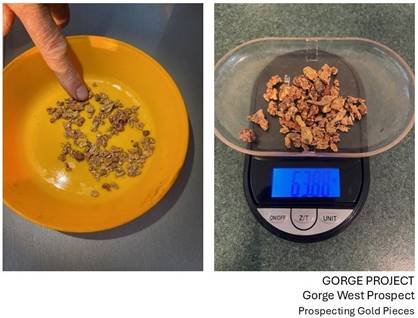
Figure 1 - Gorge West Prospect. Historic Examples of Gold Nuggets Collected from Near Surface 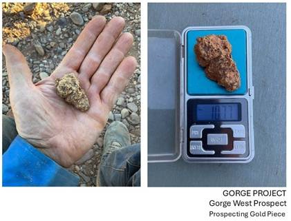
Figure 2 - Gorge West Prospect. Historic Gold Nugget Collected from Near Surface | 

