LETTER TO SHAREHOLDERS Dear Shareholders, I am pleased to present to you the GEO Exploration Limited ("GEO" or the "Company") Annual Financial Report for the year ended 30 June 2026. Operations The past year has been one of considerable progress for GEO as we continued to build the Company around high-impact exploration opportunities, with a particular focus on gold in Western Australia. The most significant development has been the rapid advancement of the Gorge Project, which is quickly developing into our flagship gold asset. Gorge covers 81km² within the Capricorn Orogen and has historical evidence of gold mineralisation extending over approximately 5km of strike, including historic rock-chip results of up to 134g/t Au and soil results of up to 233g/t Au. Following completion of the acquisition, GEO commenced a systematic programme of modern exploration including airborne magnetic and radiometric surveys, LiDAR, aerial photography, field mapping and geochemical exploration. This work has substantially advanced our geological understanding of Gorge and identified a broader pipeline of targets across the Project. Most recently, our trial soil geochemistry programme delivered highly encouraging results, with gold detected in 99.6% of samples and a peak result of 7.74g/t Au at the Gorge Mine target. The results also identified coherent gold anomalism extending beyond the historic workings and remaining open in several directions. These results have further strengthened our conviction in Gorge and we are progressing an expanded exploration programme designed to systematically refine and rank targets ahead of maiden drilling. Our wider Australian gold strategy is supported by a highly experienced technical team led by Callum Baxter, GEO's Technical Consultant and strategic partner, who was integral to the Havieron discovery in Western Australia. Callum works closely with Tom Harris, our Australian Exploration Manager, who also has direct Havieron experience, together with Dr Finbarr Murphy, whose specialist geophysical interpretation work has supported the development of the Gorge targeting model. Our ambition is clear: to apply this experience and technical capability to identify and advance geological systems with the potential to host large-scale, Tier 1-style gold discoveries. At Juno, the Company successfully completed its maiden diamond drilling programme during the year. JUD001 and JUD002 reached depths of 810.6m and 774.7m respectively and intersected the targeted geological sequences. While laboratory analysis returned low-tenor precious and base-metal mineralisation, the results have provided important geological information and the Company continues to assess the wider multi-kilometre-scale system and refine future targets. In Namibia, PEL 0094 is a legacy asset within GEO's portfolio, predating the current management team. GEO retains a 78% interest in the licence in the Walvis Basin, where independent technical work has increased licence-wide gross mean prospective resources to approximately 4.31 billion barrels. The current management team is focused on realising value from PEL 0094 in a disciplined and capital-efficient manner. Our strategy remains to secure a farm-out partner to fund and lead the next stages of exploration and development, while seeking to retain meaningful exposure to the asset's potential upside for GEO shareholders. The farm-out process remains active. During the period and subsequently, further confidentiality agreements have been entered into with prospective counterparties and a number of companies have accessed and reviewed the PEL 0094 data room. We will continue to progress these discussions while remaining focused on securing a transaction which appropriately allows for value accretion to GEO and its shareholders. Financial Position and Corporate During the year, GEO continued to strengthen both its management structure and technical capability. The Board and management team bring together experience across exploration, finance, capital markets, investment and commercial execution, while our strengthened Australian technical team provides GEO with increased in-country capability as activity across Gorge and Juno advances. A core principle of our strategy is robust and disciplined capital allocation. Exploration capital is finite and we believe it must be directed towards the opportunities which, based upon the technical evidence available at the time, offer the greatest potential to create shareholder value. This means our capital allocation will continue to evolve alongside exploration results. The rapid progress at Gorge has naturally increased its importance within our portfolio, while expenditure at Juno and Namibia will continue to be assessed against technical progress, strategic objectives and available capital. During the year, the Company completed equity raises in September and December 2025, providing capital to advance its exploration and operational activities across the portfolio. This supported a period of significantly increased activity, including the completion of the maiden drilling programme at Juno, the acquisition and rapid advancement of Gorge and the continued progression of PEL 0094 in Namibia. Following the year end, the Company raised a further approximately £1.16 million before expenses through the Placing and Retail Offer. This provides additional capital as we progress our exploration programmes, with expenditure continuing to be prioritised according to technical results, operational requirements and the opportunities which the Board believes offer the greatest potential to create shareholder value. Financial Results During the year ended 30 June 2026, the Group recorded a loss after tax of US$3,565,441 (2025: US$1,094,288) with cash balances at 30 June 2026 amounting to US$277,882 (30 June 2025: US$1,072,198). Strategy and Outlook GEO enters the next stage of its development with a clear strategy. Our primary focus is increasingly centred on our Western Australian gold portfolio, with Gorge quickly developing into our flagship asset following the highly encouraging technical and geochemical results delivered to date. At the same time, Juno provides exposure to a large-scale exploration system where the maiden drilling programme has provided important information for future targeting, while PEL 0094 provides significant strategic optionality through the ongoing farm-out process. Our objective is not simply to accumulate exploration acreage. We are seeking projects capable of delivering material discoveries and intend to combine high-quality geology, a world-class technical team and disciplined capital allocation to pursue that objective. The ambition of GEO and our technical team is to make a significant discovery. While exploration inherently carries risk, we believe the combination of our growing gold portfolio, the technical expertise we have assembled and the progress achieved over the past year provides the Company with a strong platform from which to pursue a potential Tier 1-scale discovery. I would like to thank our shareholders for their continued support and our management, technical teams and advisers for their efforts throughout the year. We look forward to continuing the advancement of GEO's portfolio and delivering the next stage of the Company's development. Omar Ahmad Chief Executive Officer |
OPERATING AND FINANCIAL REVIEW Gorge Project - Western Australia Acquisition Details: · Acquisition of 100% interest in the Gorge Project (E08/3737), Western Australia. · E08/3737 is granted and has executed Native Title Agreement in place. · Licence located 110km west of Paraburdoo, covering 81 km² of Proterozoic metasediments in the Capricorn Orogen, with gold mineralisation identified over approximately 5km of strike. · Consideration: A$100,000 cash and A$400,000 equivalent in GEO shares, issued at £0.004 per share, equating to 48,130,000 new ordinary shares. · The £0.004 issue price represents a 25% premium to GEO's £0.0032 closing price on 16 October 2025. All consideration shares subject to a 12-month holding lock until 13/1/27. · Surface Rights Deed: vendor retains near-surface gold rights to 2 metres (extendable to 4 metres with consent); capped at 10,000 tonnes excavation; GEO holds exclusive rights at depth and an option to purchase surface rights outright. · Historic exploration at Gorge identified gold mineralisation with rock chip samples up to 134g/t Au and soil samples up to 233g/t Au. GEO Exploration Limited recently acquired the licence, through its 100% owned subsidiary Gorge Gold Pty Ltd, a new exploration licence covering the Gorge Project (E08/3737) located in Western Australia. The primary focus for Gorge Project is early-stage exploration for large scale gold deposits in an area which has historically only seen sparse exploration despite encouraging results from previous work. The acquisition expands the Company's portfolio of highly prospective projects and provides a further opportunity for a potential transformational discovery. Exploration Licence 08/3737 Gorge is located approximately 110km west of the town of Paraburdoo in Western Australia. Gorge covers an area of 81 square kilometres of Proterozoic age metasediments of the Capricorn Orogen, with gold mineralisation identified over approximately 5km of strike. It is prospective for several styles of mineralisation, however the Company's primary focus will be large scale gold deposits. |
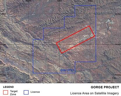
| Figure 1 - Gorge Project tenure showing existing granted licence E08/3737 |
Historical records show sporadic exploration was carried out across the Gorge licence in the mid to late 1980s and late 2000s. This work identified several areas with rock chip results peaking at 134 g/t gold, with mineralisation observed over approximately 5 km of strike. In the mid to late 1980s broad spaced stream sediment sampling, soil sampling, rock chip sampling, and Rotary Air Blast (RAB) drilling was completed within the licence area. Drainage sampling returned gold results including 192ppb and 75ppb and was successful in outlining several areas hosting gold mineralisation at surface. Rock chip sampling at these areas returned gold up to 62.2g/t from quartz veins and 35.7g/t from calcareous sediments. Soils returned up to 233.3g/t gold and shallow RAB drilling of seven holes returned highest result of 36g/t gold. Follow-up work undertaken during the late 2000s included ground reconnaissance and additional sporadic rock chip sampling, with results again peaking at 134 g/t gold and confirming mineralisation over more than five kilometres of strike. Several historical hard-rock gold workings, together with associated alluvial and eluvial areas, were identified within the licence area, along with a number of alluvial gold occurrences that are not associated with known historical hard-rock workings. No further exploration work has been carried out within the Gorge Project area since the late 2000s. However, a comprehensive compilation and review of historical datasets completed following acquisition confirmed the widespread distribution of gold mineralisation across the licence. |
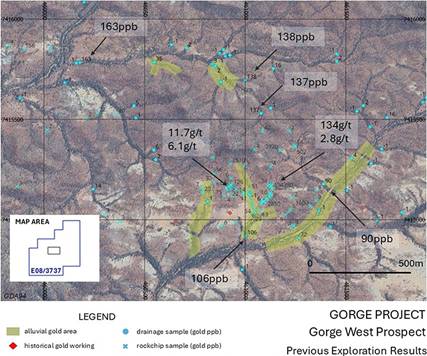
| Figure 2 - Gorge West Prospect Previous Exploration Results |
In addition, near-surface gold nuggets, recovered from alluvial areas within the licence prior to acquisition, have been reported, with individual nuggets ranging in size from less than 2 grams to pieces exceeding 100 grams, supporting the interpretation that a primary bedrock gold source may be present within the project area. |
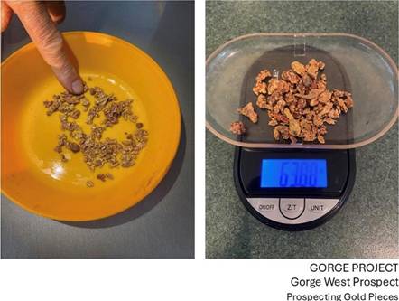
| Figure 3 - Gorge West Prospect. Examples of Gold Nuggets Collected from Near Surface |
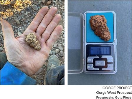
| Figure 4 - Gorge West Prospect. Examples of Gold Nuggets Collected from Near Surface |
In January 2026, the acquisition of the licence was completed, following which the Company commenced a systematic exploration programme at the Gorge Project. Based on a review of historical exploration data and recent prospecting information, the 2026 exploration programme incorporated modern exploration techniques designed to refine priority target areas and advance the project towards initial drilling, subject to the completion of the required heritage and access approvals. The programme included high-resolution airborne magnetic and radiometric surveys, airborne LiDAR surveying, surface geochemical sampling and heritage surveys. The results of these programmes have significantly enhanced the Company's understanding of the project geology and will support the planning of first-pass drilling, likely comprising Rotary Air Blast (RAB) or Reverse Circulation (RC) drilling. 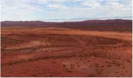 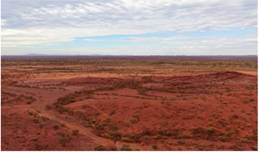
| Figure 5 - Gorge West Prospect. Examples of Gold Nuggets Collected from Near Surface |
The high-resolution LiDAR and aerial photography survey over the full Gorge Project licence area was completed ahead of schedule in May 2026 by Aerometrex Ltd. The results have materially improved GEO's ability to identify and map key surface features across the Project, including historic workings, shafts, geological outcrops, access tracks and local topography. Figure 6 shows the LiDAR-derived digital terrain model across the Project area, including target areas, historical workings and the tenement outline, providing a significantly improved surface dataset for geological and logistical planning. |
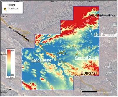
| Figure 6 - LiDAR DTM results with target areas, historical workings and tenement outline (Pseudo colour). |
At the Gorge West area, the benefits of the new dataset are particularly clear. Figure 7 shows how the aerial photography and LiDAR-derived terrain model enable clearer identification of historic shafts and workings, providing important information for follow-up mapping, access planning and future drill preparation. This information will be integrated with the magnetic, radiometric and field datasets to assist geological interpretation, target generation and planning for the proposed maiden drilling programme. |
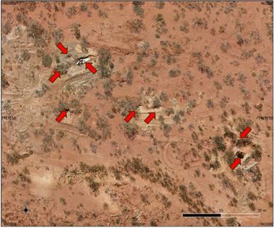
| Figure 7 - Gorge West mining area, historic shafts shown by red arrows (Aerial Photography). |
The airborne magnetic survey over the full Gorge Project licence area was completed in June 2026. The results are being used to enhance GEO's understanding of the Project's geology, structural framework, and potential controls on mineralisation. Initial interpretation of the magnetic data has improved the definition of the previously recognised approximately 5 km trend of historical gold mineralisation and workings. This trend is now interpreted as a major northeast-trending structural zone, with areas of demagnetisation that may potentially be indicative of hydrothermal fluid flow associated with a significant gold system. The mineralised gold trend is also interpreted to be offset by later northwest-trending structures. The intersection of these significant structures may represent important controls on gold mineralisation. Figure 8 shows the magnetic survey results across the Project area, including the target areas, historical workings and tenement outline. |
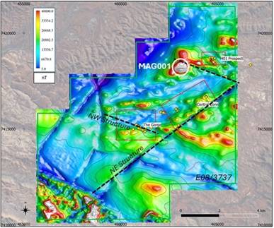
| Figure 8 - Magnetic survey results with target areas, historical workings and tenement outline (RTP image). |
The airborne survey identified a new high-priority magnetic anomaly, MAG001, in the northwest of the tenement. The anomaly is strike-limited, has an amplitude of approximately 400nT, and 3D inversion modelling indicates a depth to top of approximately 300m beneath surface with significant vertical extent. Importantly, MAG001 is coincident with a topographic anomaly identified from the recently completed LiDAR and aerial photography survey, with iron-oxide staining also observed at surface. This combination of magnetic, topographic and surface alteration features is considered encouraging and may be consistent with features observed in certain intrusion-related gold systems, including the style of target GEO is actively evaluating at its Juno Project. Figure 9 shows the magnetic depth-slice and 3D inversion model for MAG001, which will now be assessed as part of the ongoing target refinement work. |
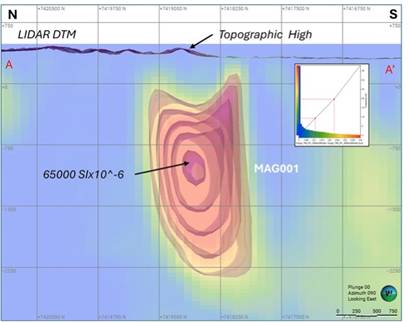
| Figure 9 - 3D magnetic inversion isosurfaces & block model. Section View - Looking East VE1. |
In addition, interpretation of the radiometric data has identified two significant uranium anomalies, RAD001 and RAD002, located proximal to the known gold trend. RAD001 is located approximately 300m from MAG001, providing a further area of interest for follow-up evaluation. The combination of magnetic and radiometric signatures is considered encouraging and may be consistent with features observed in certain Iron-Oxide-Copper-Gold (IOCG) systems, including deposits such as Carrapateena, Olympic Dam and Ernest Henry. Figure 10 shows the radiometric survey results, including the RGB ternary image and uranium channel image across the Project area. These magnetic, radiometric and topographic features will be integrated with the LiDAR, aerial photography, soil geochemistry and geological mapping datasets to assist GEO in ranking and refining priority targets for the proposed maiden drilling programme. |
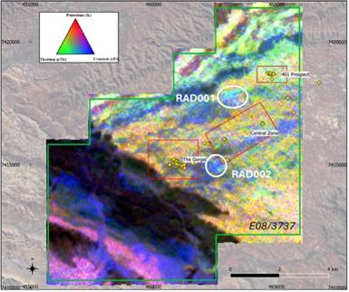
| Figure 10 - Radiometric survey results with target areas, historical workings and tenement outline. (RGB ternary image). |
Recent field reconnaissance undertaken between May and June 2026 has returned highly encouraging results across multiple target areas, further strengthening the exploration potential of the Gorge Project. The work programme has confirmed significant field indicators across the Gorge Mine Prospect, 401 Prospect, and Central Zone Prospect, including visible gold in quartz vein material, historic hard-rock workings, copper-rich gossan mineralisation, and favourable structural geological features associated with gold systems. A detailed field programme was completed across the project during this period, comprising geological mapping and structural interpretation, validation of historic exploration data, confirmation of historic shafts, costeans and drill collar locations, and the collection of 35 rock chip samples together with grab samples across selected target areas. An orientation soil geochemistry survey was also completed across key target areas to assess geochemical responses and assist in refining priority exploration targets. In addition, an orientation soil geochemistry survey was completed over key areas of known mineralisation to support the refinement of future exploration targeting. The Gorge Project is characterised by excellent surface exposure and limited alluvial cover, providing highly favourable conditions for effective surface geochemical exploration. |
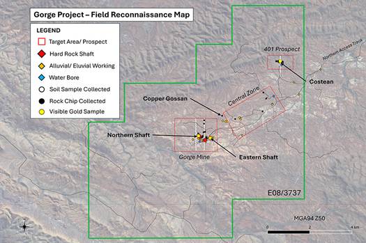
| Figure 11 - Field Reconnaissance Map |
The orientation soil geochemistry survey formed an important component of the May-June 2026 field programme and was designed to evaluate the effectiveness of soil geochemistry as an exploration tool across the Gorge Mine and 401 Prospect target areas. The survey comprised the collection of 245 soil samples from 80 sample sites across three profiles, with sampling completed at 50m spacing over known mineralised zones. All samples were submitted to Intertek Laboratories in Perth for analysis. The orientation programme was designed to determine the most effective sampling and analytical methods for a larger soil geochemistry survey planned across approximately 5 km of prospective strike, encompassing historic workings and newly identified exploration targets. The results will be integrated with geological mapping, rock chip sampling, historical exploration data and airborne geophysical survey data to refine GEO's exploration model, prioritise target areas and inform future drill planning. |
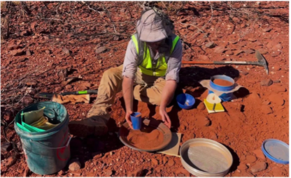
| Figure 12 - Soil Sampling at the Gorge Project |
Field mapping identified evidence of a structurally controlled mineral system, including extensive quartz veining and vein networks, faulting and folding structures, alteration zones associated with mineralisation, and sulphide and iron-oxide mineral signatures. Importantly, visible gold was observed in quartz vein samples from all three prospect areas, including material associated with historic workings and mullock heaps adjacent to vertical shafts. Samples of visible-gold-bearing material were provided by independent prospectors. These are considered encouraging and warrant controlled follow-up sampling and laboratory analysis. Structural data collected during the programme will be integrated with recently acquired airborne geophysical datasets to refine exploration targeting and identify priority drill targets. |
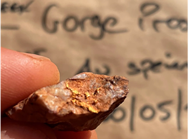
| Figure 13 - Visible gold in a quartz vein sample understood to have been sourced from mullock heaps associated with the eastern shaft at the Gorge Mine. Coarse free gold is observed along fractures and veinlets within the quartz vein samples. |
The Gorge Mine Prospect is the highest priority target area within the Gorge Project and has returned some of the most compelling indicators of high-grade gold mineralisation. Historical records combined with recent field reconnaissance undertaken highlight significant potential for further exploration. Historic Records Indicate: · Reported bedrock mineralisation extending over 1km of strike · Reported grades of up to 14 oz/t gold (approximately 450 g/t Au) · Past production of gold, silver & lead from quartz vein material · A 1.8m wide quartz vein containing sulphides including galena & cerussite |
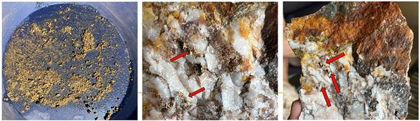
| Figure 14 - Historic photographs of quartz vein samples understood to have been sourced from the northern-most western shaft at the Gorge Mine. Pan image shows gold recovered. |
Recent reconnaissance confirmed the presence of five open vertical shafts across parts of the prospect, with the shafts measuring approximately 2m x 2m and extending to estimated depths of 20-30m. No evidence of modern exploration or drill testing was identified within the target area. Field observations also identified multiple quartz vein orientations, indicating structural complexity, while visible gold was observed within quartz vein material collected from mullock heaps adjacent to the historic shafts. Rock chip and grab samples were also collected from areas surrounding the historic workings for further analysis. Visible gold was observed in quartz vein samples sourced from historic mullock heaps adjacent to vertical shafts. While these samples were not collected under GEO's standard procedures and require controlled laboratory verification, they provide strong encouragement regarding the prospectivity of the Gorge Mine area. Historic records combined with field observations confirm the presence of significant historic hard-rock mining activity, sulphide-bearing quartz veining, and extensive alteration zones. The Gorge Mine Prospect will be prioritised for controlled sampling of historic workings and mullock heaps. Results will be integrated with geological and geophysical datasets to refine structural interpretation and define drill targets. |
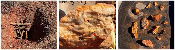
| Figure 15 - Historic eastern shaft at the Gorge Mine Prospect (left), visible coarse free gold within quartz vein material (centre), and gold-bearing material recovered during a single day of prospecting on 30 May 2026 (right). |
The 401 Prospect is one of the principal target areas within the Gorge Project and has demonstrated strong evidence of high-grade gold mineralisation through both historic exploration and GEO Exploration Limited's recent field reconnaissance. The prospect hosts extensive quartz veining, favourable alteration, and historical drilling results that support its potential as a priority exploration target. During the field programme, GEO's geological team confirmed the locations of historical diamond and RAB drill holes. This validation enables historic exploration results to be more accurately reviewed and incorporated into the Company's geological model. Key Highlights: · Historic RAB drill results include up to 35 g/t Au in RAB drilling · Historic records refer to extracted ore reportedly returning 160 oz/t Au, equivalent to more than 5,000 g/t Au. · Quartz veins up to 5 metres thickness identified during geological mapping · Pyrite alteration observed within the surrounding wall rock · Visible gold observed in quartz vein samples from historic costean areas Geological mapping at the 401 Prospect identified extensive quartz veining and associated alteration. The presence of pyrite within the surrounding wall rock further supports the existence of a hydrothermal mineralising system and provides important vectors for future exploration targeting. Visible gold observed in quartz vein material, while requiring controlled laboratory verification, is considered highly encouraging and is consistent with the presence of a mineralised quartz vein system associated with historic workings. The validation of historic drill hole locations has enabled legacy exploration data to be accurately incorporated into GEO Exploration Limited's geological model. This significantly improves confidence in the geological framework and supports more robust targeting of future exploration work. The results from field mapping, sampling, and historical data validation will be integrated with geochemical and geophysical datasets to refine exploration targets. Follow-up sampling and future drill testing are planned to assess the continuity, scale, and grade of mineralisation at the 401 Prospect. |
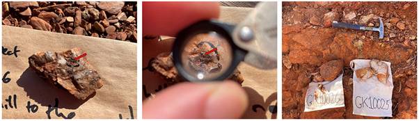
| Figure 16 - Rock chip samples collected showing low angle quartz vein with pyrite alteration in wall rock. |
The Central Zone Prospect is an important exploration target within the Gorge Project, demonstrating potential for both precious and base metal mineralisation. Field reconnaissance identified a copper-rich gossan historically worked at the contact between metasiltstone and metasandstone units, highlighting the broader multi-commodity potential of the area. Key Features: · Copper-rich gossan identified at surface · Malachite & Azurite mineralisation observed · Located at a lithological contact between Metasiltstone & Metasandstone · Multiple zones of Sericite Alteration & Quartz Veining identified · Historic workings confirm previous exploration activity These observations complement the Project's primary gold focus and support GEO's view that the Gorge Project has broader multi-commodity potential. |
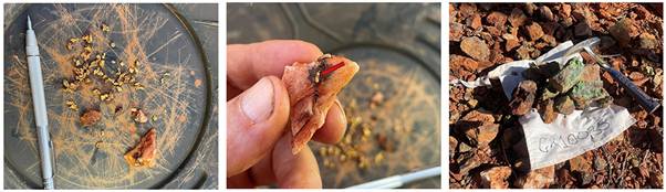
| Figure 17 - Gold-bearing material recovered by metal detecting at the Central Zone target area (left), coarse free gold associated with quartz veining and sulphide alteration (middle), and copper-rich gossanous rock samples from the Central Zone Prospect (right). |
As part of the field programme, logistical reconnaissance was also undertaken to assess site access and infrastructure requirements for future exploration activities. Key Infrastructure: · Accessible northern track network (mapped and assessed for upgrades). · 3 water bores identified across the Gorge Mine, 401 Prospect & Central Zone Prospect. · Fresh water encountered at all 3 bore locations within approx 20m of surface. The assessment confirmed several important logistical advantages that will support the efficient advancement of the Gorge Project, as exploration progresses towards drilling. |
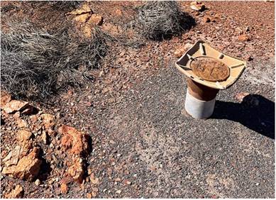
| Figure 18 - Water bore identified at the 401 Prospect. |
In July 2026, GEO Exploration Limited completed the final processing and interpretation of high-resolution LiDAR, aerial photography, magnetic and radiometric survey data across the Gorge Project in Western Australia. The integrated interpretation has significantly enhanced GEO's understanding of the Project's geological setting, structural framework, historic workings and potential controls on mineralisation. The results confirm that the Gorge Project is centred on the regionally significant Wyloo Dome. Domal geological structures are considered highly prospective exploration settings and are associated with some of Australia's major gold deposits, including Telfer in Western Australia and Fosterville in Victoria. The interpretation identified nine additional exploration targets, increasing GEO's Gorge target inventory to 12 areas while upgrading the existing rank-one targets at Gorge Mine, 401 Prospect and MAG001. |
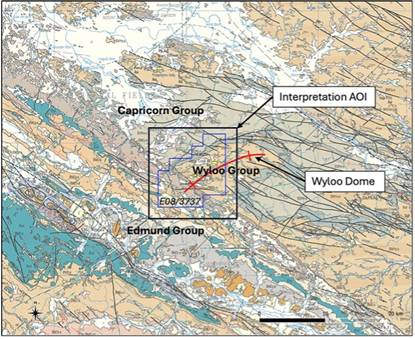
| Figure 19 - Regional Scale Geological Setting: 1:250K Mapped Geology. |
The Key Highlights: · Gorge is centred on the regionally significant Wyloo Dome, a structurally complex geological setting prospective for gold and polymetallic mineralisation. · Nine additional exploration targets identified, expanding the Gorge target inventory to 12 areas. · Existing priority targets at Gorge Mine, 401 Prospect and MAG001 have been further upgraded. · MAG001 displays coincident magnetic, radiometric, structural and surface features considered consistent with the potential presence of an intrusion-related gold system and/or an iron oxide copper-gold (IOCG)-style mineral system. · Regional interpretation has identified a major structural corridor, possible intrusive rocks at depth and multiple prospective fault intersections. · LiDAR interpretation identified 24 historic shafts and 12 trenches, demonstrating more extensive historical exploration activity than previously recognised. · Extensive quartz veining, structural complexity and historic workings provide additional vectors for follow-up exploration and target refinement. |
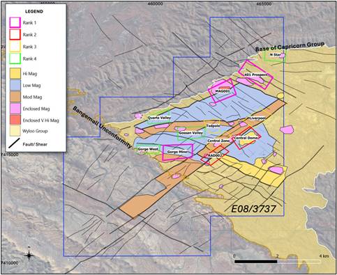
| Figure 20 - Ranked targets on Solid Geological Interpretation. |
The integrated interpretation has advanced GEO's understanding of Gorge from a series of individual historic gold occurrences into a broader geological system containing multiple potentially favourable mineralisation settings. Regional gravity, magnetic, radiometric and airborne electromagnetic datasets indicate that the Project lies within a major structural corridor associated with the Wyloo Dome. The interpretation suggests that deep-seated structures, possible intrusive bodies and areas where faults and geological units intersect may provide favourable settings for the movement and deposition of mineralising fluids. The geological features identified at Gorge share characteristics observed within a number of globally significant mineral systems and provide GEO with a strengthened geological framework for future exploration. |
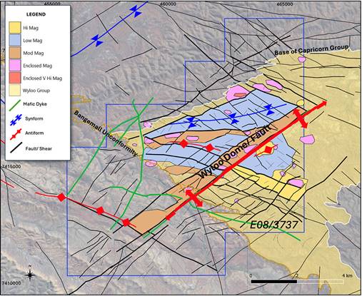
| Figure 21 - Lithology and structural interpretation: Wyloo magnetic domains. |
Gorge Mine Prospect Gorge Mine remains a rank-one priority target based on historic workings, shafts, previously reported elevated rock-chip and stream-sediment geochemistry. The target has been further upgraded following the identification of additional historic shafts and a greater density of quartz veining from LiDAR and aerial photography interpretation. The combination of historic gold workings, quartz veining, existing geochemistry and structural complexity is considered consistent with the potential presence of an orogenic gold system. 401 Prospect The 401 Prospect remains a rank-one priority target supported by historic workings, previous drilling and elevated rock-chip, soil and stream-sediment geochemistry. The final interpretation has further upgraded the target through the identification of its position along a significant northwest-southeast magnetic gradient, together with nearby magnetic closures and mapped quartz eye porphyry outcrop that may indicate the presence of a proximal intrusive body. The target is considered prospective for both orogenic and intrusion-related gold mineralisation. MAG001 Target MAG001 remains a rank-one priority target located in an area of the licence that has not previously been explored. The target comprises a significant magnetic anomaly with an associated radiometric response, structural complexity, quartz veining and surface features including iron-oxide staining. Three-dimensional inversion modelling indicates the top of the magnetic body may occur approximately 300 metres below surface, with significant interpreted vertical extent. The combined magnetic, radiometric, structural and surface signature is considered consistent with the potential presence of an intrusion-related gold system and/or IOCG-style mineral system. The interpretation has identified nine additional exploration targets through the integration of geophysical responses, structural interpretation, quartz veining, historic workings and existing geochemical information. These targets provide GEO with an expanded portfolio of exploration opportunities, enabling the Company to systematically evaluate multiple prospective areas across the Gorge Project while reducing reliance on the success of any single target. The current target rankings are summarised in the table below and will continue to evolve as further geological mapping, sampling and laboratory results are incorporated into the geological model. |
Name | Rank | Comment | Gorge Mine | 1 | Historic workings, shafts, rock chips, historic production, WNW structure, numerous quartz veins. | 401 Prospect | 1 | Historic workings, drill intercepts, rock chips, NW fault zone, margin mag high possibly intrusive. | MAG001 | 1 | Intrusive, 400nT high magnetic intensity body, subjacent high U response, structural complexity, moderate quartz veins, just beneath Capricorn unconformity. | RAD002 | 2 | U anomaly, mostly in drainage, on NE-SW Shear Zone and dyke, structural complexity, numerous quartz veins, historic workings. | Central Dome | 2 | High magnetic signature in semi-circular closure, moderate quartz veins, U enrichment to NW side of central structure. | Central Zone | 3 | Numerous quartz veins, structural complexity, large drainage area, limited outcrop. | Liverpool | 3 | Structural intersection, Au stream 82 ppb, moderate quartz veins. | Tadpole | 3 | Antiform, low order structural intersection, moderate quartz veins, historic workings. | Gossan Valley | 4 | Cu gossan, moderate quartz veins, structural complexity, disrupted magnetic gradients. | Gorge West | 4 | Moderate quartz veins, on strike from Gorge Mine. | N Star | 4 | Intrusive high magnetic signature, quartz veins. |
A litho-structural interpretation of the recently acquired airborne geophysical survey data is currently underway. This work will support the selection of priority areas for follow-up exploration and drill targeting, as well as improve understanding of structural controls on mineralisation. In August 2026, GEO announced highly encouraging assay results from the trial soil geochemistry programme completed at the Gorge Project in Western Australia in May 2026, comprising 245 soil samples collected across the Gorge Mine and 401 Prospect target areas. Gold was detected in 244 of 245 samples (99.6%), demonstrating a widespread gold-in-soil response. Importantly, 140 samples returned values above 0.01 g/t Au, the approximate local background level, including 27 samples above 0.1 g/t Au, considered strongly anomalous, and 5 samples above 1.0 g/t Au, considered extremely anomalous. The peak assay of 7.74 g/t Au was returned approximately 150 metres southwest of the mapped vertical shafts at the Gorge Mine target, where the strongest and most coherent gold anomalism was identified. Coherent gold anomalism was also identified to the northeast, northwest and southwest of the historic workings and remains largely open in all directions. At the 401 Prospect, the results confirmed elevated gold anomalism associated with an east-west-trending zone of auriferous quartz veining. Multi-element analysis identified positive relationships between gold and several pathfinder elements, including silver, scandium, molybdenum, tungsten, tin and arsenic. These elemental associations are consistent with IRGS and Orogenic Gold mineral system signatures. The results will materially inform the next phase of exploration, comprising an expanded 1,188-sample soil geochemistry programme on a 200m by 50m grid across the known 5km mineralised corridor and priority targets identified from airborne geophysical surveys. The programme will also include detailed geological mapping, rock-chip geochemistry and controlled sampling of historic workings, with the results expected to further define and rank priority targets and assist with planning for the proposed maiden drilling programme, subject to the required heritage and government permitting. Key Soil Geochemistry Results: · 7.74 g/t Au peak soil assay at Gorge Mine · 99.6% of samples returned detectable gold · 5 samples >1.0 g/t Au - considered extremely anomalous · 27 samples >0.1 g/t Au - considered strongly anomalous · 140 samples >0.01 g/t Au - above the approximate local background level · Strong and coherent gold anomalism at Gorge Mine, with significant anomalism also confirmed at 401 Prospect · Pathfinder elemental associations consistent with IRGS and Orogenic Gold mineral system signatures · Gold anomalism at Gorge Mine remains largely open in all directions · Results to define and rank targets for proposed maiden drilling |
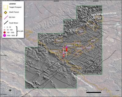
| Figure 22 - Soil geochemical assay results for gold shown on LiDAR DTM. |
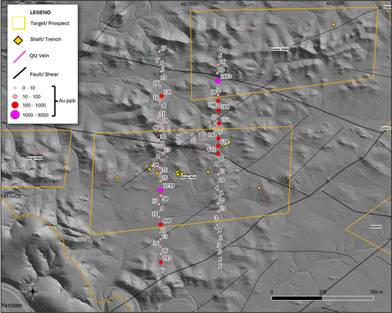
| Figure 23 - Soil geochemical assay results for gold shown on LiDAR DTM. |
Juno Project - Western Australia As part of the Company's transformation agenda, in August 2024, the Company announced the acquisition of a 70% interest in a joint venture ("the JV") with Callum Baxter. The JV is focused on the advancement of mineral exploration licence 08/3497 located in Western Australia, in a region recognised for its rich mineral deposits. Callum Baxter was Chief Technical Officer of Greatland Gold plc and was Chairman and CEO of Starvest plc. Callum was the key Geologist in the advancement and exploration of the Havieron Gold discovery in Western Australia, one of the largest high-grade gold discoveries in Australia in the last two decades. Callum Baxter is a member of the Australian Institute of Geoscientists and the Australasian Institute of Mining and Metallurgy. Under the terms of the Joint Venture, GEO: · Acquired an initial 70% of the licence for consideration of £200,000. · Exercised a 3 month option to purchase an additional 10% of the licence for £50,000 thus increasing GEO's interest to 80% of the licence, with Callum Baxter retaining 20%. · Is committed to a minimum expenditure of £750,000 (capital commitment) under the JV over the 12 months following completion. · Is to fund 100% of the JV expenditure up to the "Decision to Mine", after which both parties will contribute according to their JV interests. · Is the JV Manager and responsible for all exploration activities and must furnish technical reports to Callum Baxter. · Will pay up to a 5% royalty on any future production from the Licence. This royalty structure ensures that both parties benefit proportionally from the success of the project. The Company has subsequently been granted two further Exploration Licences, 52/4391 and 08/3744, adjacent to the licence, via its wholly owned subsidiary Juno Gold Pty Ltd. The total area of the Juno Project has increased from 106 square kilometres initially to 450 square kilometres covering multiple magnetic features. In February 2025, GEO applied for a new Exploration Licence, 08/3792, north of the current Exploration Licence 08/3497 in Western Australia, via its wholly owned subsidiary Juno Gold Pty Ltd. Upon the licence being granted, the total tenure for Juno will be 644 square kilometres covering multiple magnetic features. |
| 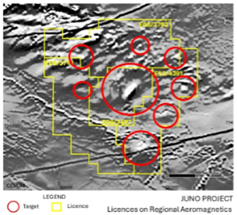
Figure 24 - Juno Project tenure showing existing granted licence E08/3497, E52/4391 and E08/3744 |
The Project, targeting Intrusion-Related Gold Systems (IRGS), has seen significant advancements through a series of geophysical surveys, including aeromagnetic, gravity, and LiDAR data collection. These activities have been aimed at identifying and refining high-potential drill targets, with the ultimate goal of discovering large-scale gold and copper mineralisation similar to the Havieron deposit in the Paterson Province. In early October 2024, GEO Exploration commenced an Airborne geophysical Survey at the Juno Project. This survey, which covered over 3,900 line kilometres, was designed to acquire high-resolution aeromagnetic data to better understand the subsurface geology. This survey was completed by mid-October, marking a significant milestone in the exploration program. The data collected revealed a strong, discrete magnetic feature, consistent with the characteristics of IRGS deposits, in the northern part of the Project area, this magnetic feature, not visible in historical lower-resolution surveys, provided the first clear indication of the Project's potential. During September 2024, Callum Baxter, GEO Exploration's Joint Venture Partner, conducted a site visit to assess access to the Project area and engage with local stakeholders. The visit confirmed that access to the site was viable via historical tracks, and discussions with local pastoralists were positive, with strong support for the exploration activities. Following the successful completion of the aeromagnetic survey, GEO Exploration initiated a ground-based gravity survey in late November 2024. This survey, conducted on a 400m x 200m grid (with 200m x 200m spacing in areas requiring higher resolution), focused on the northern part of the Project area. In early January 2025, GEO Exploration received the final LiDAR (Light Detection and Ranging) data for the Juno Project. The LiDAR survey, which provides high-resolution topographic and surface imagery, delivered Digital Terrain Models (DTMs) at 0.5m and 1.0m resolution, along with detailed digital imagery of the ground surface. The spatial accuracy of the LiDAR data was less than 20cm, making it a critical tool for refining drill targets and planning exploration activities. The LiDAR data, combined with the aeromagnetic and gravity data, has significantly enhanced the Company's ability to model the subsurface and identify high-potential drill sites. In mid-January 2025, the delivery of ground gravity data was received confirming a significant residual gravity response coinciding with the large magnetic feature previously identified. The gravity response covers an area of approximately 4km x 2km (8 sq km) with a peak amplitude of 2mgal, which is larger and more intense than the response observed at the Havieron deposit. The coincident magnetic and gravity response is a strong indicator of IRGS and IOCG (Iron Oxide Copper-Gold) mineralization, further validating the Project's potential. |
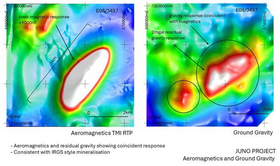
| Figure 25 - Juno Aeromagnetics and Ground Gravity |
Historical drilling attempts in the 1990s and early 2000s targeted the magnetic feature but failed to reach the target depth due to limitations in drilling technology. Modern drilling equipment and advanced geophysical modelling techniques are expected to overcome these challenges, providing a clear pathway for exploration drilling. In May 2025, geophysical modelling showed independent 3-D magnetic-gravity inversions locked onto a single, coherent 4 × 2 km intrusive body, with the top of the system interpreted at ~600 m depth. Historic drillhole PHD001 terminated just short of this target, confirming immediate drillability. The modelling provides centimetre-scale collar positions for the maiden drill programme. |
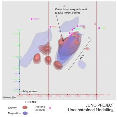
| Figure 26 - Juno Project 3D unconstrained results showing coincident magnetic and gravity model bodies |
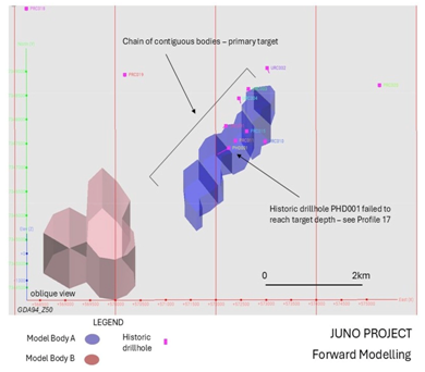
| Figure 27 - Juno Project 3D Forward Modelling results showing primary target |
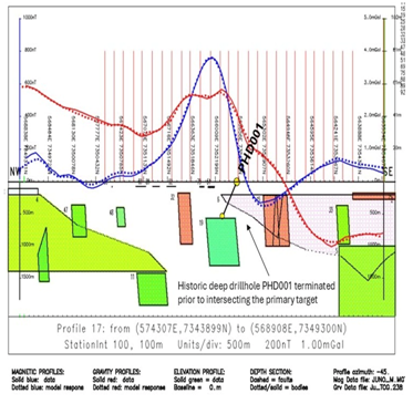
| Figure 28 - Juno Project Forward Modelling Profile 17 showing primary target model body 19 |
In May 2025, a comprehensive Heritage Agreement was executed with the Nharnuwangga Wajarri & Ngarlawangga Traditional Owners. The agreement establishes clear protocols for activities from reconnaissance to potential development, removing the final non-technical barrier to drilling while ensuring protection of cultural heritage. In June 2025, IP & EM Surveys were conducted where field crews mobilised for dipole-dipole induced-polarisation (IP) and moving-loop electromagnetic (EM) surveys across the northern anomaly. In July 2025, the IP and EM responses were successfully modelled from subsurface data and the geophysical responses observed have upgraded the Juno Project from an IRGS perspective. This resulted in the proposed maiden drillhole locations being confirmed and will be drilled to depths of between 750m and 1000m and are planned to be vertical. In August 2025, the Company engaged DDH1, a world-class drilling contractor, to undertake our maiden drill programme. Our maiden drill programme at the Juno Project commenced in Q3 of calendar year 2025. Drillhole JUD001 was completed on 15 September 2025 to a final depth of 810 metres, successfully intersecting all targeted sequences. The drilling of the second hole, JUD002, commenced after JUD001 had completed. Together, these milestones advanced the Juno Project from target delineation to drill-ready status, and following the capital raise in January 2025, the Company was well-capitalised as per the capital commitment terms outlined above for its maiden drilling programme which commenced in September 2025. |
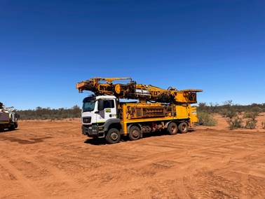
| Figure 29 - Arrival of Drilling Equipment |
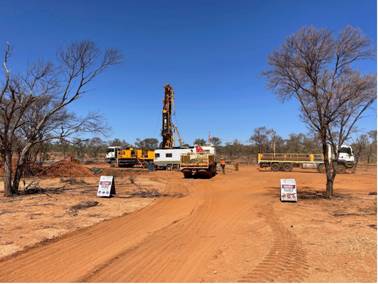
| Figure 30 - Drilling at JUD001 |
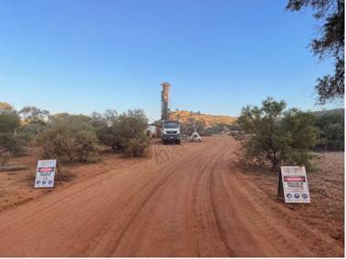
| Figure 31 - Drilling equipment on site at drill hole JUD002 |
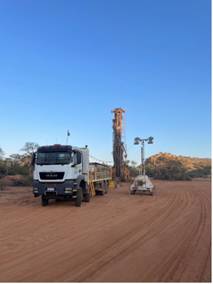
| Figure 32 - Drill hole at JUD002 |
The Company conducted its maiden drilling programme at the Juno Project in September and October 2025. Safe and efficient progress was made during drilling activities, JUD001 and JUD002 advanced as planned, intersected the expected rock sequences, and achieved adequate depths to assess targets in the chosen drillhole locations. Drillhole JUD001 was vertical and drilled to a total depth of 810.6m, and JUD002 was vertical and drilled to a total depth of 774.7m. Geology intersected was late Proterozoic shales and carbonates underlain by early Proterozoic carbonate rich metasediments. Depth to targeted basement was 246.7m in JUD001 and 262.0m in JUD002. Structural and metamorphic alteration of intersected rocks was apparent. Analytical work was carried out on JUD001 and JUD002 by Intertek Laboratories in Perth where each 1m core sample was analysed for a comprehensive multi-element suite of precious metals, base metals and pathfinder elements (49 elements). Gold and copper results were returned from targeted basement in JUD001 and JUD002. Silver and zinc results were returned from overlying rocks in holes JUD001 and JUD002. Results show mineralisation was intersected in drillhole JUD001 and JUD002 with low tenor precious and base metals returned from laboratory analysis. In the targeted basement sequence low tenor gold and copper sulphide mineralisation was sporadically intercepted in the hole locations drilled. A photo of example mineralisation from JUD001 is shown in Figure 33. Considering the large multi kilometre scale of the modelled geophysical target at Juno the Company believes mineralisation intersected in JUD001 and JUD002 may represent a peripheral portion of a larger system. Higher grade mineralisation may be present proximal to these drillholes and further review of analytical data with geological and geophysical information will be carried out. |
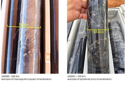
| Figure 33 - Juno Project Drill Core Photos |
Further review of data will be carried out and if other valid targets emerge then the Company may direct future drilling efforts to other locations within the multi kilometre scale Juno geophysical target and updates will be provided to the market accordingly. The Company believes exploration is a systematic, multi-programme learning process and further drilling is warranted to test for the presence of higher-grade mineralisation within the large multi kilometre scale of the Juno geophysical target. GEO is progressing further exploration work at Juno, including the development of a 3D geological model and additional geochemical studies using multi-element assay and continuous XRF analysis data to refine future drill targets. Considering the large multi kilometre scale of the modelled geophysical target at Juno the Company believes mineralisation intersected in JUD001 and JUD002 may represent a peripheral portion of a larger system. Higher grade mineralisation may be present proximal to these drillholes and further review of analytical data with geological and geophysical information will be carried out. |
Namibian Project The Namibian Project consists of an operated 78 per cent participating interest in Petroleum Exploration Licence ("PEL") 0094 (acquired in 2018) which covers Block 2011A. Since the Company was awarded PEL0094, it has purchased and interpreted historic 2D and 3D seismic data over Block 2011A and across the Walvis Basin to enable a better understanding of the petroleum system and the resource potential of PEL0094. Various studies have been undertaken which have confirmed the view that PEL 0094 is very prospective. The Company purchased additional 2D seismic data in 2022 and carried out further technical interpretation both on the principal prospects (Marula and Welwitschia Deep) and on the leads in the eastern part of PEL0094. On 20 May 2025, the Company announced an independent significant resource upgrade for PEL0094. Licence-wide unrisked gross mean Prospective Resources have risen 22 % to c.4.31 billion barrels, with GEO's 78 % working interest translating to c.3.37 billion barrels unrisked (429 MMbbl risk-adjusted). The update introduced two new sandstone leads, Emerald (Albian) and Beryl (Cenomanian), which together account for c.792 MMbbl gross mean resources and materially de-risk the eastern sector of the block. In total, nine 2D-defined leads in the east now contain c.3 billion barrels gross mean resources, while the drill-ready 3D-imaged prospects Marula and Welwitschia Deep remain the primary near-term targets. Structural mapping shows robust dip- and fault-bounded closures in water depths of c. 750 m, supported by direct hydrocarbon indicators such as gas chimneys and flat spots. On 14 August 2023, the Company announced that the Namibian authorities had given approval for the Company and its partners to proceed to the First Renewal Exploration Period ("FREP"), which commenced on September 2023. Importantly, the usual requirement at the end of the Initial Exploration Period ("IEP") to relinquish 50 per cent of PEL 0094 area was waived. The work commitment for the FREP is to acquire, process and interpret 2,000 kms of 3D seismic data (the "3D Seismic") - carried over from the IEP and to drill a well contingent upon the results of interpretation of the 3D Seismic. Since early 2022, Namibia's oil and gas exploration sector has transformed due to significant oil discoveries in the Orange Basin. Total Energies and its partners made the Venus discovery and later drilled Mangetti-1X. Galp also made a significant discovery at Mopane-1X. The Orange Basin has seen increased activity with Woodside, Chevron, and Azule entering the region, providing reason to believe Namibia is on the path to becoming a major petroleum-producing province. In April 2025, operator Rhino Resources and partner Azule Energy (BP & Eni JV) reported a light-oil discovery at the Capricornus-1X well in PEL 85 in Namibia's deep-water Orange Basin. This further underpins the upward potential of the region with interest now moving north to the Walvis basin. In January 2025, Shell announced an approximately US$400m write-down in Namibia due to the high gas-to-oil ratio and gas condensate in its PEL0039 discoveries. This, combined with low rock permeability and high extraction costs, has meant that PEL0039 discoveries are yet to be confirmed for commercial viability. Chevron in the Orange basin for Block 2813B within PEL 90 also did not discover any commercial hydrocarbons in January 2025. Despite these setbacks, Namibia's oil potential remains strong, with other companies advancing more promising offshore projects and attention has shifted to the Walvis Basin, where PEL0094 is located. Public comments made by operators working in the Orange Basin have indicated that some of the reservoirs have low permeabilities and that there is a substantial volume of gas in the discoveries to date. The shallower reservoirs in PEL94 are less buried than their counterparts in the Orange Basin discoveries so, all other things being equal, should be less diagenetically altered and have higher permeabilities. Petroleum systems modelling carried out in conjunction with Geo's team by world-renowned geochemical consultancy IGI Ltd indicates that the source rock in the migration segments for the prospects and leads in PEL94 is in the main to early oil windows, and, although from a source rock of this type some gas would be expelled with the oil, the predominant hydrocarbon phase is modelled to be oil. Chevron's farm-in announcement in 2024 for PEL0082 close to PEL0094 and subsequent announcement that it seeks drilling permits for up to 10 wells in September 2025 has increased industry interest in the Walvis Basin, with other recent activity in December 2025 with Eco Atlantic Oil & Gas entering into a strategic partnership with Navitas Petroleum, which includes an option for Navitas to acquire an interest in Eco's Walvis Basin Namibian licences. GEO's strategy remains to secure a farm-out partner to fund and lead the next stages of exploration and development, with the objective of achieving the best possible transaction for the Company and its shareholders. A number of interested parties have accessed the PEL 94 data room as part of their evaluation of the opportunity, while further confidentiality agreements with additional companies have been signed or are progressing, supporting continued engagement in the farm-out process. |
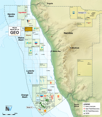
| Figure 34 - Map of Namibia showing PEL0094 |
Italian Applications In August 2013, the Company submitted applications for four offshore exploration areas in the Southern Adriatic, which are contiguous with the Italian median lines with Croatia, Montenegro, and Albania. Following a series of appeals against the environmental decrees related to these applications, the European Court confirmed in January 2022 that the applications did not violate EU law. In February 2019, the Italian Parliament suspended all hydrocarbon exploration activities for 18 months to evaluate their suitability under a new Plan, which came into effect in February 2022. This Plan mandates that only gas exploration is permitted, leading to a re-perimeterisation of the Company's application areas. The Italian Ministry of Ecological Transition later confirmed that the amended applications complied with the Plan. In September 2023, the Company announced that appeals against the environmental decrees granted in its favour had been dismissed by the Council of State. These appeals were related to all four of the Company's exploration permit applications in the Southern Adriatic. There have been no updates since June 2024. The Company will continue to assess its options regarding the applications and make further announcements as needed. Overall, across the business GEO applies a disciplined approach to capital allocation, with a fluid and continuous assessment of its project portfolio. Licences that no longer demonstrate clear value-add or progression potential will be reconsidered for impairment or exit. |
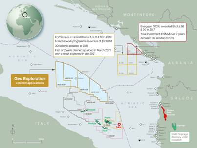
| Figure 35 - Map of Permit Applications - Italy Offshore |
EVENTS SUBSEQUENT TO REPORTING DATE Since the end of the financial year, the Company has announced several material developments: · Gorge Project - Nine Further Targets Identified from Airborne Geophysical Interpretation - On 28 July 2026, the Company announced the final interpretation of the airborne geophysical surveys at the Gorge Project, which identified nine additional exploration targets, increasing the target inventory to 12, while further upgrading the Gorge Mine, 401 Prospect and MAG001 targets. The interpretation also identified a major structural corridor, possible intrusive rocks at depth and more extensive historical workings than previously recognised, including 24 shafts and 12 trenches. · Gorge Project - Highly Positive Results from Trial Soil Geochemical Survey - On 24 August 2026, the Company announced highly encouraging results from its trial soil geochemistry programme, with gold detected in 244 of 245 samples (99.6%), five samples returning greater than 1.0 g/t Au and a peak result of 7.74 g/t Au at the Gorge Mine target. Following these results, the Company has progressed an expanded exploration programme comprising approximately 1,188 soil sample sites across the known approximately 5 km mineralised corridor and priority targets, together with geological mapping, rock-chip geochemistry and controlled sampling to further refine targets ahead of proposed maiden drilling. · Capital Raise - On 10 September 2026, the Company announced a placing at 0.06 pence per share, with a separate Retail Offer made available at the same issue price. On 15 September 2026, the Company announced the result of the Retail Offer and confirmed that the Placing and Retail Offer had raised aggregate gross proceeds of £1,157,825 before expenses. The proceeds are intended to support exploration and drilling at Gorge, further exploration at Juno, PEL 0094 licence upkeep and work programme commitments, and general operational and corporate costs. The Directors are not aware of any other matter or circumstance that has arisen since 30 June 2026 which has significantly affected, or may significantly affect, the operations of the Group, the results of those operations, or the state of affairs of the Group in subsequent financial periods. · Drilling Grants - Western Australia - On 15 October 2026, the Company announced that it had been awarded A$280,000 in drilling grants under the Western Australian Government's Co-Funded Exploration Drilling Programme (Round 34), comprising A$180,000 for the Gorge Project and A$100,000 for the Juno Project. The grants will support diamond drilling programmes targeting high-priority exploration targets at both projects. The Company intends to undertake the drilling programmes in the first half of 2027, subject to operational arrangements and regulatory approvals. |
|


