11th May 2026 07:41

Greatland Resources Limited
W: https://greatland.com.au
NEWS RELEASE | 11 May 2026
Exploration Update - West Dome Underground
Step-out drilling hits 58.7m @ 6.5g/t gold & 0.1% copper at Pinnacles prospect 1.2km south of the West Dome Underground resource, indicates extension of geological structure and stratigraphy
Highlights
· 1,858m exploration diamond drill hole (WRC14503A) recently drilled from surface at the Pinnacles prospect, to test potential extension of the geological structures and stratigraphy that host the West Dome Underground (WDU) deposit, approximately 1.2km to the south of the current WDU Mineral Resource Estimate (MRE).
· The Pinnacles drill hole intersected high grade mineralisation and indicates a significant extension of the West Dome geological structure. Assay results include the following significant intercepts:
· 58.7m @ 6.5g/t Au & 0.1% Cu from 1,754m (approximately true width), including:
· 37.0m @ 9.98g/t Au & 0.14% Cu from 1,754m (approximately true width); and
· 34.1m @ 1.1g/t Au from 1,820m.
· The mineralisation is open to the north towards the WDU, and to the south, which is entirely untested. Further drilling is required to confirm the tenor and extent of the mineralisation between the WDU and the Pinnacles intersection, as well as to the south.
· This new intercept is situated approximately 1.5km from the existing Telfer underground crusher and hoist infrastructure.
· Follow-up work to be completed includes:
· Wedge holes from drill hole WRC14503A, to test mineralisation between 50-100m along strike and down dip.
· Planning for drilling between Pinnacles and WDU, and extension drilling further south of Pinnacles.
Greatland Managing Director, Shaun Day, commented:
"It is a credit to our Exploration team to have first interpreted the potential extension of the West Dome Underground at Pinnacles, a significant distance from our current area of focus, and then to successfully plan and execute this drill hole from surface to its target at depth.
"The wide high-grade mineralisation, including 58.7m @ 6.5g/t gold & 0.1% copper (381.6 gram-metres gold), is among the best intercepts achieved from West Dome Underground drilling to date.
"While the result is a single drill hole, it demonstrates the potential extension of West Dome Underground mineralisation to the south of our current resource. This new intercept is in similar proximity to our existing underground crusher and hoist infrastructure as the current West Dome Underground resource, further adding to its prospectivity.
"Further drilling will now be planned to test the existence and tenor of mineralisation between the two zones."
Overview of the West Dome Underground projects
Greatland Resources Limited (Greatland or Company) (ASX:GGP, AIM:GGP) is pleased to provide this exploration update on the West Dome Underground (WDU) project.
The WDU emerged from the recognition that key geological structures hosting mineralisation in the Main Dome Open Pit repeat in the West Dome Open Pit. Accordingly, it was proposed that the geological features that are key to mineralisation in the Main Dome Underground (Figure 1), may repeat below the West Dome Open Pit.
The WDU was a high priority target identified by Greatland's due diligence prior to the acquisition of Telfer. Following completion of the acquisition, Greatland accelerated drilling in CY2025 from newly established underground positions, with a total of 18,963m drilled to December 2025. Greatland's drilling has confirmed that the key geological units hosting the Main Dome Underground mineralisation are present in the WDU.
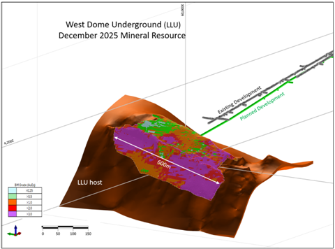
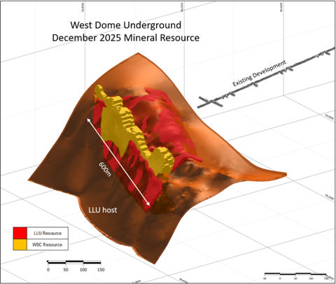
On 30 March 2026, Greatland announced a maiden Mineral Resource Estimate (MRE) for WDU1, comprising 8.0Mt @ 2.30g/t Au & 0.44% Cu for 0.6Moz Au & 35Kt Cu. The WDU MRE is contained within an anticline hinge and hosted across two key domains: the high-grade sulphide replacement Lower Limey Unit (LLU) and the broad mineralised Western Stockwork Corridor (WSC) (Figure 2).
Note 1: Refer to Greatland's 30 March 2026 announcement titled 'December 2025 Group Mineral Resource Statement'.
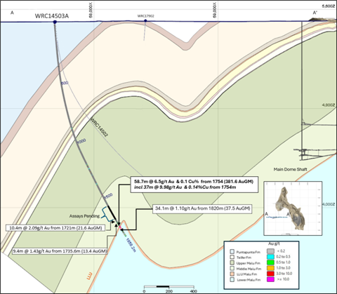
Figure 1: Telfer December 2025 Mineral Resource schematic, showing location of Pinnacles drill hole and closest historical intercepts.
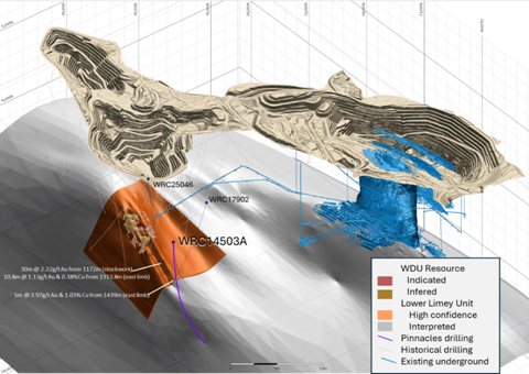
Figure 2: West Dome Underground December 2025 Mineral Resource isometric view.
Pinnacles prospect
The Pinnacles prospect is located approximately 1km south of the West Dome Open Pit and 1.2km south of the current WDU resource.2
Utilising the strong understanding of the Telfer geological structures and stratigraphy from both the recent WDU drilling and historical shallower drilling between the current WDU resource and the Pinnacles prospect, a 1.8km diamond drilling (DD) drill hole was commenced from surface, targeting the West Dome anticline hinge within the LLU stratigraphic layer. This target was interpreted to lie approximately 1,750m downhole.
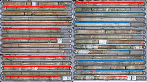
Drilling of diamond hole WRC14503A commenced in December 2025 and reached the target depth in April 2026. Massive pyrite with ancillary chalcopyrite and quartz veining, likely replacing the LLU, were intersected from 1,758m downhole and extended to 1,772m, with interbedded sediments, quartz breccias and narrow massive sulphides to 1,792m. Stockwork quartz veining and sulphides continue to end of hole at 1,858m, and also occur 4m above the LLU contact, commencing at 1,754m (Figures 3, 5).
Note 2: Drilling was described in Greatland's 22 January 2026 announcement titled 'December 2025 Quarter Resource Development & Exploration Activities Report'.
Figure 3: Core photos of top of mineralised section from 1,757.75m downhole to 1,782.2m showing the massive sulphide zone (red line) and the stockwork mineralisation in sediments (blue line). Core is laid out top to bottom then left to right.
The massive sulphide and interbedded sediments zone to 1,792m is interpreted to correlate to the WDU LLU strata bound orebody containing the majority of the current WDU resource. The stockwork breccia is similarly considered to be the WDU vertical WSC in the core of the WDU anticline hinge below the LLU. This interpretation is supported by the target stratigraphy and structure being intersected within approximately 10m of its predicted down plunge location, 1,200m down plunge of the current WDU resource.
Further evidence of the extension of the West Dome structure is from the existence of several narrow reef style veins at around 1,640m downhole in the Middle Malu formation above the LLU, which are of similar style to the A-reef's at Main and West Dome.
The intercept of 58.7m @ 6.5g/t Au & 0.1% Cu (381.6 gram-metres Au (gm) 3) from 1,754m includes 37m @ 9.98g/t Au & 0.14% Cu from 1,754m, which approximates to the LLU with the massive sulphide identified in the core. These assays are considered to be dominantly stratabound and were intersected by the drill hole at a high angle to bedding, making them close to true width intersections of the mineralisation.
A further intercept of 34.1m @ 1.1g/t Au (37.5 gm Au) from 1,820m extends below the LLU, within the lower interpreted vertical stockwork corridor, and weak mineralisation extends further to the end of hole.
While this result indicates the extension of the structure and geology from the WDU to the Pinnacles prospect, further drilling will be required to confirm the existence and tenor of mineralisation between the two zones.
Note 3: Formula: gm = interval width multiplied by Au grade.
Figure 4: Pinnacles drilling location with respect to existing WDU resource and underground infrastructure - isometric view looking NNW.
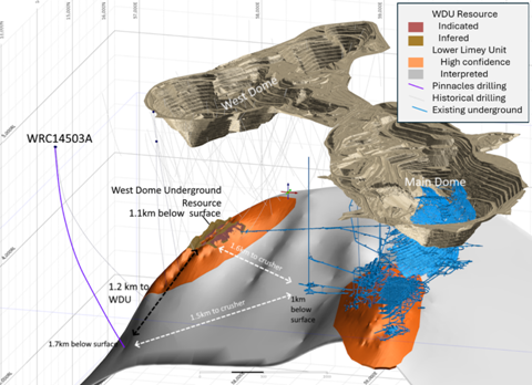
Figure 5: Pinnacles hole WRC15403A showing intercepts and Telfer shaft on interpreted geology with LLU in orange (200m+/- clip).
Proximity to existing underground infrastructure
The Main Dome Underground (MDU) is situated below the Main Dome Open Pit, and to date has mined over 75Mt of ore, for more than 3.1Moz gold and 210kt copper.
The MDU crusher and hoist to surface is located at a depth of approximately 1,000m below surface and is approximately 1.5km north-east of the Pinnacles mineralisation, which is similar to the distance between the current WDU resource and the crusher and hoist (Figure 4).
The underground crusher and hoist provide an efficient and low-cost materials handling system that transports ore from the underground crusher to surface and is then directly conveyed into train 1 of the Telfer processing plant. This underground materials handling system has a capacity of approximately 6Mtpa and has been in continuous use since its completion in 2007.
Currently the Main Dome Underground is operating at a mining rate of approximately 1.2Mtpa. Accordingly, there is significant latent infrastructure capacity at the MDU to support potential mining operations at WDU, including:
· ~6Mtpa crushing and hoist haulage capacity via the existing shaft;
· water pumping infrastructure with installed capacity of 132L/s, with current mining activities in the MDU utilising on average 50L/s;
· ventilation infrastructure designed for approximately 5Mtpa SLC, currently operating as a ~1.2Mtpa stoping operations;
· electricity generation from the Telfer power plant and transmission via the MDU; and
· a paste plant.
Next steps
Planning is underway to complete at least three wedges off hole WRC14503A with the aim of gaining 50-100m of separation of intercepts along strike both north and south (Mine Grid) and down dip within the LLU massive sulphide.
Further surface drilling to infill the 1.2km strike length between Pinnacles and the current WDU resource, to confirm the existence and tenor of mineralisation between these zones and potentially enable extension of the WDU resource, is also being considered, as is the potential for an underground drill out of this zone.
This announcement is approved for release by Shaun Day, Greatland's Managing Director.
Contact
For further information, please contact:
Greatland Resources Limited
Shaun Day, Managing Director | Andrew Bowler, Head of Investor Relations
Nominated Advisor
SPARK Advisory Partners
Andrew Emmott / James Keeshan / Neil Baldwin | +44 203 368 3550
Corporate Brokers
Canaccord Genuity | James Asensio / George Grainger | +44 207 523 8000
RBC Capital Markets | James Agnew / Jamil Miah | Scott Redwood | +44 207 029 0528
Media Relations
Australia - Fivemark Partners | Michael Vaughan | +61 422 602 720
About Greatland
Greatland is a gold and copper mining company listed on the Australian Securities Exchange and London Stock Exchange's AIM Market (AIM:GGP, ASX:GGP), and operates its business from Western Australia.
The Greatland portfolio includes the 100% owned Telfer mine, the adjacent 100% owned brownfield world-class Havieron gold-copper development project, and a significant exploration portfolio within the surrounding region. The combination of Telfer and Havieron provides for a substantial and long-life gold-copper operation in the Paterson Province in the East Pilbara region of Western Australia.
Forward-Looking Statements
This document includes forward-looking statements and forward-looking information within the meaning of securities laws of applicable jurisdictions. Forward-looking statements can generally be identified by the use of words such as "may", "will", "expect", "intend", "plan", "estimate", "anticipate", "believe", "continue", "objectives", "targets", "outlook" and "guidance", or other similar words and may include, without limitation, statements regarding estimated reserves and resources, certain plans, strategies, aspirations and objectives of management, anticipated production, study or construction dates, expected costs, cash flow or production outputs and anticipated productive lives of projects and mines.
These forward-looking statements involve known and unknown risks, uncertainties and other factors that may cause actual results, performance and achievements or industry results to differ materially from any future results, performance or achievements, or industry results, expressed or implied by these forward-looking statements. Relevant factors may include, but are not limited to, changes in commodity prices, foreign exchange fluctuations and general economic conditions, increased costs and demand for production inputs, the speculative nature of exploration and project development, including the risks of obtaining necessary licences and permits and diminishing quantities or grades of reserves, political and social risks, changes to the regulatory framework within which Greatland operates or may in the future operate, environmental conditions including extreme weather conditions, recruitment and retention of personnel, industrial relations issues and litigation.
Forward-looking statements are based on assumptions as to the financial, market, regulatory and other relevant environments that will exist and affect Greatland's business and operations in the future. Greatland does not give any assurance that the assumptions will prove to be correct. There may be other factors that could cause actual results or events not to be as anticipated, and many events are beyond the reasonable control of Greatland. Forward-looking statements in this document speak only at the date of issue. Greatland does not undertake any obligation to update or revise any of the forward-looking statements or to advise of any change in assumptions on which any such statement is based.
Competent Persons Statement
Information in this announcement pertaining to exploration results is based on, and fairly represents, information and supporting documentation compiled by and approved by Mr Damien Stephens, a Member of the Australian Institute of Mining and Metallurgy (AusIMM), who has more than 30 years relevant industry experience. Mr Stephens, an employee of the Company, has sufficient experience relevant to the style of mineralisation, type of deposit under consideration, and to the activity which he is undertaking to qualify as a Competent Person as defined by the 2012 Edition of the Australasian Code for Reporting of Exploration Results, Mineral Resources and Ore Reserves (the JORC Code) and under the AIM Rules - Note for Mining and Oil & Gas Companies, which outline standards of disclosure for mineral projects. Mr Stephens consents to the inclusion in this announcement of the exploration results and the supporting information in the form and context in which they are presented.
This announcement contains references to Mineral Resource estimates for Telfer, which have been extracted from the Company's ASX announcement dated 30 March 2026 titled 'December 2025 Group Mineral Resource Statement'. The Company confirms that it is not aware of any new information or data that materially affects the information included in those announcements, and in the case of the estimates of Mineral Resource and Ore Reserve, that all material assumptions and technical parameters underpinning each of the estimates in the relevant ASX announcement continue to apply and have not materially changed.
Drillhole Data and Au-Cu Significant Intersections
Significant assay intercepts are reported as length-weighted averages in Table 1 and Table 2. Intervals less than 10 Au gram metres and those with <1 g/t Au average grade have not been included.
All Telfer exploration primary intervals are calculated at 0.2g/t Au cut-off and minimum 0.1m downhole width with 5m maximum consecutive internal dilution.
Table 1: Significant intercepts & drilling data (Telfer Mine Grid).
HOLEID | EAST | NORTH | RL | Depth | Dip | Azimuth | From | To | Width (m) | Au ppm | Cu pct | Au (GM) |
WRC14503A | 57682 | 11454 | 5498 | 1858.2 | -84.9 | 80 | 1721 | 1731.4 | 10.4 | 2.09 | 0.02 | 21.6 |
1735.6 | 1745 | 9.4 | 1.43 | 0.04 | 13.4 | |||||||
1754 | 1812.7 | 58.7 | 6.5 | 0.10 | 381.6 | |||||||
1820 | 1854.1 | 34.1 | 1.1 | 0.04 | 37.5 |
Table 2: Historical intercepts & drilling data (Telfer Mine Grid).
HOLEID | EAST | NORTH | RL | depth | Dip | Azimuth (grid) | from | to | Width (m) | Au ppm | Cu pct | Au (gm) |
WRC14502 | 57690 | 11453 | 5498 | 1500 | -85 | 85 | No significant intercepts |
|
|
| ||
WRC17902 | 58415 | 11790 | 5506 | 1788 | -74 | 346 | 387 | 398 | 11 | 0.27 | 0.01 | 13 |
|
|
|
|
|
|
| 717.57 | 734 | 16.4 | 16.66 | 0.015 | 18 |
|
|
|
|
|
|
| 772 | 776.05 | 4 | 14.88 | 0.003 | 21 |
|
|
|
|
|
|
| 835 | 851 | 16 | 0.21 | 0.071 | 19 |
|
|
|
|
|
|
| 1376.85 | 1378.1 | 1.3 | 46.7 | 0.034 | 25 |
|
|
|
|
|
|
| 1439 | 1444 | 5 | 3.73 | 0.045 | 20 |
|
|
|
|
|
|
| 1539 | 1550 | 11 | 0.64 | 0.059 | 12 |
WRC25046 | 58182 | 12509 | 5520 | 1608 | -85 | 85 | 1172 | 1202 | 30 | 1.77 | 0.231 | 67 |
|
|
|
|
|
|
| 1313.75 | 1324.5 | 10.8 | 3.12 | 0.127 | 12 |
JORC 2012 Table 1: Section 1 - Sampling Techniques and Data
Criteria | Commentary |
Sampling techniques | All current samples are obtained from diamond drilling. Diamond core (PQ-HQ and NQ) was cut using an automated core saw and sampled as half core. Predominately 1m samples were obtained, but lengths range from 0.2 metre to 1.2 metre if adjusted to geological or major alteration boundaries. All available drill core was sampled. |
Drilling techniques | Diamond core drilling was from surface with PQ3, HQ3 and NQ2 diameter coring configuration and from RC pre-collars, generally starting with HQ3 and ending in NQ2. Core from drill holes is orientated on 1.5m, 3m and 6m runs using an Axis CHAMP ORI™ orientation tool. At the end of each run, the bottom of hole position is marked by the driller, which is later transferred to the whole drill run core run length with a bottom hole reference line. |
Drill sample recovery | Core recovery is systematically recorded from the commencement of coring to end of hole by reconciling against drillers depth blocks in each core tray with data recorded in the database. Driller's depth blocks provided the depth, interval of core recovered, and interval of core drilled. Core recoveries were 95 - 100%. |
Logging | All core samples were geologically logged by geologists and are considered to have been logged in appropriate detail to support Mineral Resource estimation, mining studies and metallurgical studies. Basic geotechnical logging of RQD was completed by field technicians or geologists. Core logs were qualitative and quantitative in nature. Lithology and alteration were logged qualitatively; mineralisation, veining, structure and geotechnical data (RQD) were logged quantitatively. Core was photographed both dry and wet after metre marking and orientation. 100% of all recovered core were logged in the targeted stratigraphy. Magnetic susceptibility, sometimes with conductivity measurements were recorded every metre using a KT20 or KT10 machine. Bulk density of selected drill core intervals was determined at site on whole core samples using the Archimedes method. Logging information was digitally recorded and validated prior to import into an acQuire database. |
Sub-sampling techniques and sample preparation | All sampled core was cut with an automatic core saw in a consistent way that preserved the bottom of hole reference line, where present. Half core was used for normal sampling and quarter core for field duplicates. Samples were collected in pre-numbered calico bags mostly 1 metre in length, but also ranged from 0.2m to 1.5m. Sample weights typically varied from 0.5kg to 7kg. Sample sizes are considered appropriate for the style of mineralisation. Assaying quality control procedures consisted of the inclusion of certified reference material (CRM) and blank samples at an insertion rate of 1:20 and 1:40 respectively. Duplicate samples were collected from crush and pulp samples at a rate of 1:20. Samples were prepared at the Telfer Laboratory or freighted by road to Intertek Laboratory, Perth (Intertek). Samples were dried at 105oC, and the bulk of the samples pulverised (using LM5) to produce a pulped product with minimum standard of 95% passing 106µm. Oversize primary samples were crushed and a 3kg subsample then milled with the LM5 mill. Routine grind size analysis is conducted. |
Quality of assay data and Laboratory tests | Assaying of drill core samples was conducted at Intertek. All samples were assayed for 48 elements using a 4-acid digestion followed by ICP+MS/OES finish. MS determination (method 4A/MS907), which is considered to provide a total assay for copper. Gold analyses were determined by 50g fire assay with AAS finish (method FA50N/AA), which is considered to provide a total assay for gold. Sampling and assaying quality control procedures consisted of inclusion of certified reference material (CRMs), coarse residue and pulp duplicates with each batch (at least 1:20). Assays of quality control samples were compared with reference samples in the database and verified as acceptable prior to use of data from analysed batches. Laboratory quality control data, including laboratory standards, blanks, duplicates, repeats and grind size results are captured in the SQL databases and assessed for accuracy and precision for recent data. Analysis of the available quality control sample assay results indicates that an acceptable level of accuracy and precision has been achieved and the database contains no analytical data that has been numerically manipulated. The assaying techniques and quality control protocols used are considered appropriate for the data to be used for reporting exploration drilling results. |
Verification of sampling and assaying | Sampling intervals defined by the geologist are electronically assigned sample identification numbers prior to core cutting. Corresponding sample numbers matching pre-labelled calico bags are assigned to each interval. All sampling and assay information were stored in a secure database with restricted access. Electronically generated sample submission forms providing the sample identification number accompany each submission to the laboratory. Assay results from the laboratory with corresponding sample identification are loaded directly into the database. No twinned holes have been completed. There are no currently known drilling, sampling, recovery, or other factors that could materially affect the accuracy or reliability of the data. |
Location of data points | Drill collar locations were surveyed using a differential Trimble R10 differential GPS with RTK with a stated accuracy of +/- 0.01m accuracy or handheld Garmin 67/66i GPS with an accuracy of +/- 5m. Drill rig alignment was attained using a REFLEX TN14 GYROCOMPASS™. Downhole survey was collected every 6m and 30m using a Reflex OMNIx™42 north seeking gyro tool. Mining operations at Telfer Gold Mine adhere to periodic reporting requirements for the WA Department of Mines, Industry Regulation and Safety (DMIRS), using the MGA94/AHD coordinate system for official submissions. However, site operations utilise the Telfer Mine Grid (TMG) and Telfer Height Datum (THD), requiring coordinate transformations between the national and operational coordinate systems. This has been supplied by AAM Surveys in 1995 (AMG84 to Telfer Mine Grid) and AAMHATCH in February 2007 (Telfer Mine Grid to MGA Transformation). Both reports also addressed the height datum and in 2007 established the THD=AHD + 5193.7m. A local grid covers the whole of the Telfer mine area (Telfer Mine Grid 2002). It is oriented with grid north at 44o03'12' west of magnetic north All collar coordinates are provided in the Telfer Mine Grid 2002 |
Data spacing and distribution | Individual holes are targeting specific targets, and are not part of a grid pattern, all holes are orientated at approximately 90 degrees to the interpretation geological strike of the intended target.
|
Orientation of data in relation to geological structure | Diamond holes are orientated perpendicular to the interpreted strike of the target. The hole was angled at 85⁰ from surface to intersect the moderate to steeply dipping sandstone and siltstone stratigraphy, reef and stock work mineralisation at a high angle.
|
Sample security | The security of samples is controlled by tracking samples from drill rig to database. Drill core was generally delivered from the drill rig to the Telfer core yard every shift. Samples were either prepped at the onsite laboratory and flown to Intertek in Perth or freighted in sealed bags, labelled by bar codes, by road to the Laboratory by an authorised freight company. All samples are collected in pre-numbered calico bags. Verification of sample numbers and identification is conducted by the laboratory on receipt of samples, and sample receipt advise issued to Greatland. Details of all sample movement are recorded in a database table. Dates, Hole ID sample ranges, and the analytical suite requested are recorded with the dispatch of samples to analytical services. Any discrepancies logged at the receipt of samples into the analytical services are validated. |
Audits or reviews | No audits for reviews have been completed.
|
JORC 2012 Table 1: Section 2- Reporting of Exploration Results
Criteria | Commentary |
Mineral tenement and land tenure status | The Pinnacles Prospect is located on M 45/7 which is 100% owned by Greatland Pty Ltd, An Indigenous Land Use Agreement (ILUA) has been in place since December 2015, covering all operational aspects of the site. Telfer operations also remain compliant with the Mining Rehabilitation Fund (MRF) levy. The Telfer district was first geologically mapped by the Bureau of Mineral Resources in 1959, though no gold or copper mineralization was identified. In 1971, regional sampling by Day Dawn Minerals NL detected anomalous copper and gold at Main Dome. From 1972 to 1975, Newmont Pty Ltd conducted extensive exploration and drilling, defining an open pit reserve primarily in the Middle Vale Reef. In 1975, BHP Gold acquired a 30% stake in the project, and in 1990, Newmont and BHP Gold merged their Australian assets to form Newcrest Mining Limited. Newcrest managed exploration and resource drilling from 1990 until its acquisition by Newmont Corp on November 6, 2023. Newmont later divested Telfer, selling it to Greatland Gold on December 4, 2024, which now oversees exploration and drilling activities. No previous drilling at Pinnacles targeting the LLU horizon has been undertaken. The nearest hole intersecting the LLU was collared >800m to the north. |
Exploration done by other parties | Newcrest and Newmont have completed multiple phases of drilling since the discovery of the Telfer mine to aid in the resource development. This work identified mineralisaton within the LLU at what has now been defined as the West Dome Undergound resource by Greatland. This resource sits 1.2km to grid north of the Pinnacles intersection. This drilling including the Greatland subsequent drillout provides a strong framework for the geological and structural interpretation of the Telfer host rock sequence, which was used to target the pinnacles hole. There is a single drilling intersection of the targeted Lower Limey Unit in hole WRC17902 on the eastern limb of the WDU antiform approximately 730m to grid north of the Pinnacles hole which, while showing mineralisation did not intersect the target hinge zone. There is no other drill testing of the LLU south of this hole along the West Dome / Pinnacles trend. |
Geology | Telfer is located within the northwestern Paterson Orogen and is hosted by the Yeneena Supergroup, a 9 km thick sequence of marine sedimentary rocks. Gold and copper mineralization occurs in stratiform reefs and stockworks within the Malu Formation of the Lamil Group, controlled by both structure and lithology. Mineralisation styles include high-grade narrow reefs, reef stockwork corridors, sheeted vein sets, and extensive low-grade stockwork, which forms most of the sulphide resource. Sulphide mineralisation at Telfer consists mainly of pyrite and chalcopyrite, with copper minerals including chalcopyrite, chalcocite, and bornite. Gold is primarily free-grained or associated with sulphides and quartz/dolomite gangue, with a correlation between vein density and gold grade. The highest gold and copper grades occur within bedding sub-parallel reef systems, including multiple reef structures in Main Dome and West Dome, such as E-Reefs, MVR, M10-M70 reefs, A-Reef, B-Reefs (notably B30) and the LLU. Additional mineralisation occurs in northwest-trending and north-dipping veins. Stockwork mineralisation, found in open pits, Telfer Deeps the Vertical Stockwork Corridor (VSC) and the Western stockwork corridor (WSC), is best developed in the axial zones of Main Dome and West Dome, often extending over large areas (0.1 km to 1.5 km). It can include brecciated zones filled with quartz, carbonate, and sulphides. |
Drill hole information | Refer to Table 1 and Table 2 - Significant Intercepts. |
Data aggregation methods | Significant assay intercepts are reported as length-weighted averages in Table 1 and Table 2. Intervals less than 10 Au gram metres and those with <1 g/t Au average grade have not been included. All Telfer exploration primary intervals are calculated at 0.2g/t Au cut-off and minimum 0.1m downhole width with 5m maximum consecutive internal dilution. No top cuts are applied to intercept calculations. |
Relationship between mineralisation widths and intercept lengths | Drill holes were angled to intersect steeply to moderately dipping geological targets at high angles. All significant assay intervals are down hole widths as the true orientation of mineralisation is currently unknown. |
Diagrams | As provided. |
Balanced reporting | The report is considered balanced. |
Other substantive exploration data | See body of announcement and figures. |
Further work | Further work is required at Pinnacles including additional wedge and extension holes. |
Related Shares:
Greatland Resources