
24th Sep 2026 07:00
THIS ANNOUNCEMENT CONTAINS INSIDE INFORMATION FOR THE PURPOSES OF ARTICLE 7 OF REGULATION 2014/596/EU WHICH IS PART OF DOMESTIC UK LAW PURSUANT TO THE MARKET ABUSE (AMENDMENT) (EU EXIT) REGULATIONS (SI 2019/310) ("UK MAR"). UPON THE PUBLICATION OF THIS ANNOUNCEMENT, THIS INSIDE INFORMATION (AS DEFINED IN UK MAR) IS NOW CONSIDERED TO BE IN THE PUBLIC DOMAIN.
NOT FOR RELEASE, PUBLICATION OR DISTRIBUTION, IN WHOLE OR IN PART, DIRECTLY OR INDIRECTLY IN OR INTO THE UNITED STATES, AUSTRALIA, CANADA, JAPAN, THE REPUBLIC OF SOUTH AFRICA OR ANY OTHER JURISDICTION WHERE TO DO SO WOULD CONSTITUTE A VIOLATION OF THE RELEVANT LAWS OF SUCH JURISDICTION.
24 September 2026
Cobra Resources plc
(“Cobra” or the “Company”)
Porphyry Indicators Confirmed at Blue Rose: 23m at 0.63% Cu incl. 12.4m at 1.01% Cu
Follow-up RC drilling commences, targeting strike extensions at Blue Rose and testing Netley Hill and Anabama prospects
Cobra (LSE: COBR), a South Australian mineral exploration and development company advancing the Wudinna Rare Earth Project and the Manna Hill Copper Project, is pleased to report results from two of four completed Diamond Drilling (“DD”) holes from Blue Rose, a copper-gold-molybdenum discovery within the Manna Hill Copper Project.
Mineralisation has now been defined to depths beyond 300m and the style of mineralisation and associated geological features support a greater porphyry system.
In addition, the next phase of exploration has commenced with slimline RC drilling across multiple targets.
Highlights:
Porphyry source confirmed: DD drilling below the shallow skarn discovery at Blue Rose returned solid copper–gold intersections, molybdenum mineralisation and hydrothermal breccias. All three are typical of the upper parts of a porphyry system.
Two ~1% Cu zones in first two holes:
MHDD002: 23m at 0.63% Cu, 0.09 g/t Au from 186m, incl. 12.4m at 1.01% Cu, 0.13 g/t AuMHDD004: 36m at 0.39% Cu, 0.05 g/t Au from 232m, incl. 10m at 0.99% Cu, 0.13 g/t Au, 0.02% Mo
Molybdenum vector: MHDD004 returned 16.9m at 0.08% Mo from 335.5m, incl. 1.1m at 0.48% Mo, within strongly altered wall rock contacting a hydrothermal breccia – Mo is a primary pathfinder for porphyry vectoring.
Open at depth: mineralised intervals extend beyond 300m downhole in both holes and remain open.
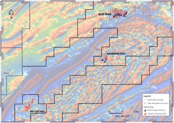
Next steps: assays are pending from MHDD001 and MHDD003. Up to 6,000m of follow-up RC drilling (52 holes) is now underway across four prospects (Figure 4).
Rupert Verco, Managing Director commented:
“There is extensive copper mineralisation defined within these two drill holes. Collectively, mineralisation within MHDD002 totals 50 metres at half a percent copper, while collective mineralisation within MHDD004 totals 80 metres at 0.30 percent copper. MHDD004 also returned a separate 16.9m intersection at 0.08% molybdenum – this element both supports economics and provides an important vector for the system’s hydrothermal source.
Results add to the scale potential of Blue Rose, extending the depth of mineralisation beyond 300m. The commencement of RC drilling is the next step in defining the scale, targeting both shallow skarn and recognised porphyry systems. Drilling is expected to continue over the next six weeks with results to follow.
Now is a pivotal time to invest in new copper discoveries, with copper trading near record levels while tightening supply and rising electrification demand reinforce the strategic value of new resources. The macro story is obvious: increasing demand, tightening supply and increasing costs of discovery. Our investment thesis is clear: shallow and scalable copper.”
Follow this link to watch a short video of CEO Rupert Verco explaining the results released in this announcement: https://investors.cobraplc.com/link/exdp3e
Further Information Regarding results
Four DD drillholes totalling 1,465m tested geophysical and geological indicators for a porphyry type source to shallow Cu-Au skarn mineralisation where earlier RC drilling has yielded standout intersections including:
RABR822: 47m at 2.2% Cu, 0.76 g.t Au from 11mMHRC0018: 20m at 0.78% Cu, 0.14 g/t Au from 38m, and 74m at 1.02% Cu, 0.25 g/t Au from 70mMHRC0017: 86m at 0.60% Cu, 0.14 g/t Au from 18mMHRC0013: 62m at 1.0% Cu, 0.08 g/t Au from 62mMHRC0003: 56m at 0.34% Cu from 34m
Geochemical, structural and geological observations from DD drilling support skarn mineralisation being associated with a deeper hydrothermal porphyry source.
Mineralisation has been defined to depths beyond 300m, where the style of mineralisation and associated geological features support a greater porphyry system.
DD drilling results include:
MHDD002: 6.7m at 0.22% Cu, 0.03 g/t Au from 171.5m, and23m at 0.63% Cu, 0.09 g/t Au from 186m, including:12.4m at 1.01% Cu, 0.13g/t Au from 190m, and1.7m at 0.61% Cu, 0.24 g/t Au from 228m, and3.2m at 0.78% Cu, 0.5 g/t Au from 252.6m, including 1.1m at 1.86% Cu, 1.38 g/t Au from 252.6m, and10.5m at 0.38% Cu, 0.02 g/t Au from 297.9m
MHDD004: 16.9m at 0.21% Cu from 16.6m, and5.6m at 0.43% Cu from 171.4, and5m at 0.29% Cu, 0.02 g/t Au from 221.7m, and36m at 0.39% Cu, 0.05g/t Au from 232m, including:10m at 0.99% Cu, 0.13 g/t Au, 0.02% Mo from 241.5, and 1.8m at 0.34% Cu, 0.03g/t Au from 315m, and16.9m at 0.08% Mo from 335.5m, including1.1m at 0.48% Mo from 351.3m
The high molybdenum grades and its direct association to a large hydrothermal breccia is evidence of a much larger mineral system - molybdenum is a primary pathfinder for porphyry vectoring as it is generally more proximal to the potassic alteration zone which becomes more enriched in metals and can host higher grade copper.
Assays from select intervals from the two remaining holes are pending. Petrology and petrophysical test work are also pending for all four holes.
Manna Hill is located in the Nackara Arc, South Australia, a fertile copper-gold province where multiple underexplored prospects offer potential for large-scale copper-gold discoveries, including shallow skarn mineralisation and deeper porphyry potential.
Table 1: Reported downhole significant intersections (0.1% Cu or 0.02% Mo cutoff with 3m internal dilution)
Hole ID | From (m) | To (m) | Int (m) | Cu % | Au g/t | Mo ppm |
MHDD0002 | 141.1 | 142 | 0.9 | 0.28 |
| 4 |
and | 143.8 | 144.9 | 1.1 | 0.18 |
| 1 |
and | 171.5 | 178.2 | 6.7 | 0.22 | 0.03 | 3 |
and | 186.03 | 209 | 22.97 | 0.63 | 0.09 | 24 |
incl. | 190 | 202.4 | 12.4 | 1.01 | 0.13 | 37 |
and | 215.2 | 216.3 | 1.1 | 0.14 | 0.08 | 10 |
and | 220.1 | 222 | 1.9 | 0.19 | 0.09 | 6 |
and | 228 | 229.7 | 1.7 | 0.61 | 0.24 | 69 |
and | 252.6 | 255.8 | 3.2 | 0.78 | 0.50 | 34 |
incl. | 252.6 | 253.7 | 1.1 | 1.86 | 1.38 | 91 |
and | 297.9 | 308.35 | 10.45 | 0.38 | 0.02 | 16 |
incl. | 298.2 | 299.4 | 1.2 | 0.98 | 0.07 | 18 |
MHDD0004 | 16.55 | 33.4 | 16.85 | 0.21 |
| 3 |
and | 42.4 | 44.3 | 1.9 | 0.13 |
| 7 |
and | 73.2 | 74.2 | 1 | 0.11 |
| 0 |
and | 171.35 | 176.92 | 5.57 | 0.43 | 0.01 | 15 |
incl. | 172.35 | 173.35` | 1 | 1.32 | 0.03 | 48 |
and | 178.35 | 179.35 | 1 | 0.12 | 0.05 | 0 |
and | 182.35 | 183.35 | 1 | 0.15 |
| 1 |
and | 190.25 | 191.3 | 1.05 | 0.13 |
| 111 |
and | 216.08 | 217.65 | 1.57 | 0.17 | 0.02 | 66 |
and | 221.7 | 226.7 | 5 | 0.29 | 0.02 | 13 |
and | 232 | 268 | 36 | 0.39 | 0.05 | 91 |
Incl. | 237.6 | 253.4 | 15.8 | 0.73 | 0.09 | 182 |
incl. | 241.5 | 251.5 | 10 | 0.99 | 0.13 | 212 |
and | 281.05 | 281.45 | 0.4 | 0.10 | 0.01 | 43 |
and | 285.5 | 286.5 | 1 | 0.15 | 0.01 | 16 |
and | 291.7 | 295.7 | 4 | 0.13 | 0.01 | 7 |
and | 305.8 | 306.7 | 0.9 | 0.21 |
| 12 |
and | 314.95 | 316.75 | 1.8 | 0.34 | 0.03 | 72 |
and | 328.6 | 329.7 | 1.1 | 0.12 | 0.02 | 2 |
and | 335.5 | 352.4 | 16.9 | 0.01 | 0.00 | 808 |
incl. | 351.3 | 352.4 | 1.1 | 0.00 | 0.01 | 4760 |
Figure 1: Plan of completed drilling, both reported and pending results
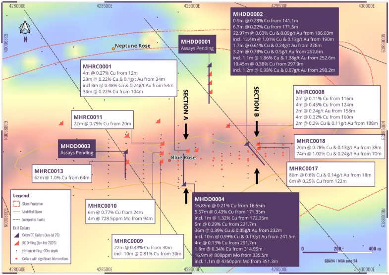
Figure 2: Section A: 429,375mE highlighting significant intersections within drillholes MHDD0004, and high-grade molybdenum mineralisation proximal to hydrothermal breccia
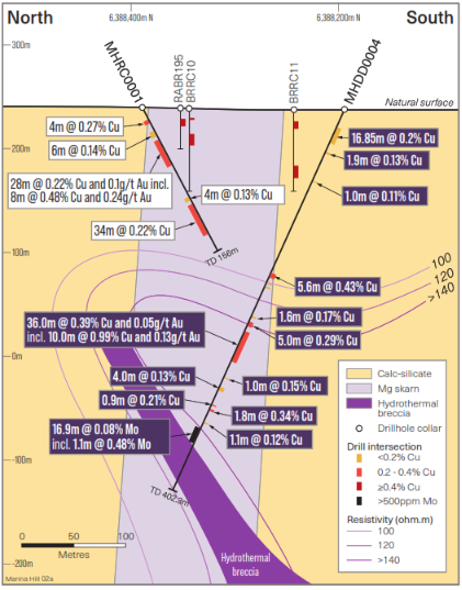
Figure 3: Section B: 428,950mE highlighting significant intersections within drillholes MHDD0002
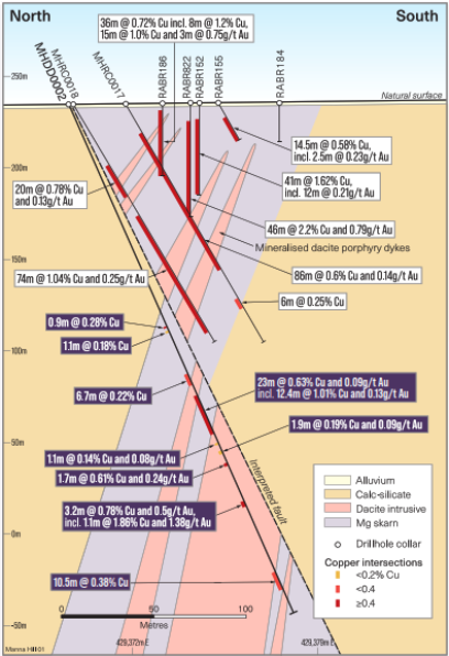
Figure 4: Manna Hill planned drilling
Competent Person’s Statement
Information in this announcement has been assessed by Mr Rupert Verco, a Fellow of the Australasian Institute of Mining and Metallurgy. Mr Verco is an employee of Cobra and has more than 18 years’ industry experience which is relevant to the style of mineralisation, deposit type, and activity which he is undertaking to qualify as a Competent Person as defined in the 2012 Edition of the Australasian Code for Reporting of Exploration Results, Mineral Resources and Ore Reserves of JORC. This includes 13 years of Mining, Resource Estimation and Exploration. Mr Verco consents to the inclusion in this announcement of the matters based on his information in the form and context in which it appears.
About Cobra
Cobra Resources is advancing two South Australian critical minerals opportunities: the Wudinna ionic rare earth project and the Manna Hill copper project.
At Wudinna, Cobra is advancing a rare earth discovery that is amenable to low-cost, low-disturbance controlled-aquifer in situ recovery (ISR), with the potential to progress towards small-scale production and bottom-quartile recovery costs, becoming the Western World’s first rare earths ISR operation.
Cobra is also advancing the Manna Hill copper project in the Nackara Arc, where multiple underexplored prospects offer potential for large-scale copper-gold discoveries, including shallow skarn mineralisation and deeper porphyry potential.
Cobra also holds a significant shareholding in Barton Gold (ASX: BDG), following the 2025 sale of its non-core gold assets for A$15 million in cash and shares.
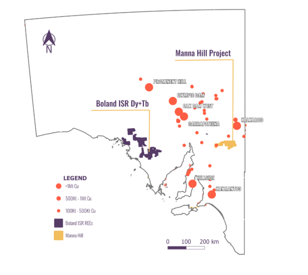
Regional map showing Cobra’s tenements in South Australia
Follow us on social media:
LinkedIn: https://www.linkedin.com/company/cobraresourcesplc
X: https://twitter.com/Cobra_Resources
Engage with us by asking questions, watching video summaries and seeing what other shareholders have to say. Navigate to our Interactive Investor hub here: https://investors.cobraplc.com/
Subscribe to our news alert service: https://investors.cobraplc.com/auth/signup
Appendix 1: Collar coordinates and drillhole details, coordinates in MGA94, Zone 54
Hole number | Northing | Easting | RL (m) | EOH (m) | Azimuth | Dip |
MHDD0001 | 6388875.866 | 429098.043 | 234.33 | 440.35 | 180 | -60 |
MHDD0002 | 6388427.000 | 429311.000 | 233.55 | 321.4 | 140 | -60 |
MHDD0003 | 6388380.933 | 428618.545 | 238.19 | 301.5 | 180 | -60 |
MHDD0004 | 6388194.256 | 428952.036 | 235.89 | 402.3 | 360 | -65 |
Appendix 2: JORC Code, 2012 Edition – Table 3
Criteria | JORC Code explanation | Commentary |
Sampling techniques | Nature and quality of sampling (eg cut channels, random chips, or specific specialised industry standard measurement tools appropriate to the minerals under investigation, such as down hole gamma sondes, or handheld XRF instruments, etc). These examples should not be taken as limiting the broad meaning of sampling.Include reference to measures taken to ensure sample representivity and the appropriate calibration of any measurement tools or systems used.Aspects of the determination of mineralisation that are Material to the Public Report.In cases where ‘industry standard’ work has been done this would be relatively simple (eg ‘reverse circulation drilling was used to obtain 1 m samples from which 3 kg was pulverised to produce a 30 g charge for fire assay’). In other cases more explanation may be required, such as where there is coarse gold that has inherent sampling problems. Unusual commodities or mineralisation types (eg submarine nodules) may warrant disclosure of detailed information. | Historic Drilling Historic drill programs have been conducted by multiple companies and methods the historically reported results are being reviewed prior to any broader reporting of results. In general lab assay results across differing programs show comparable tenors of grade and distribution.
2026 RC Drilling RC drill cuttings were collected from the drill rig cyclone in 1 m intervals in industry standard green bags, with a 2 m representative split from the cyclone collected into a calico bag. The green and calico bags were arranged in rows on site for sampling and assaying.2 m samples were split using a cone splitter mounted on the drill rig.Samples were submitted to BV Laboratories, Perth for analysis.
2026 Diamond Drilling HQ sized diamond core was cut and half core sampled.Sampling was generally kept to 1m intervals but adjusted to honour geological boundaries.2-4kg half core samples were submitted to ALS Laboratories for geochemical analysis. |
Drilling techniques | Drill type (eg core, reverse circulation, open-hole hammer, rotary air blast, auger, Bangka, sonic, etc) and details (eg core diameter, triple or standard tube, depth of diamond tails, face-sampling bit or other type, whether core is oriented and if so, by what method, etc). | Historic Drilling Historic drill methods were predominantly aircore and RC drilling with some diamond drilling reported
2026 RC Drilling Schramm T685 RC rig operated by Bullion Drilling Pty Ltd. The RC drilling was conducted using a 5 ¾-inch hammer. A booster air compressor was used throughout the program. Diamond DrillingUDR 1000 drill rig operated by MJ Drilling Pty Ltd. The diamond drilling was conducted using HQ sized core from surface (except one hole which re-entered a previously drilled RC hole to continue as a diamond tail). HQ core samples were collected from the diamond drill rig from nominal 3 m drill runs and placed into industry standard core trays. Where broken ground was intersected, run lengths were reduced as appropriate. |
Drill sample recovery | Method of recording and assessing core and chip sample recoveries and results assessed.Measures taken to maximise sample recovery and ensure representative nature of the samples.Whether a relationship exists between sample recovery and grade and whether sample bias may have occurred due to preferential loss/gain of fine/coarse material. | Historic recoveries have not been assessed. Drill methods and geological conditions are not expected to promote significant reduced recovery or sample biasing 2026 RC Drilling Bulk RC samples were visually assessed and considered to be representative with good recoveries. Recoveries were recorded onsite into Cobras MX Deposit database.Water was intersected in several drillholes. Where outside return was lost and sample recovery reduced. Recovery estimates recorded into the companies database. Shroud tolerance was managed to optimise recovery. Diamond DrillingCore blocks were utilised by the drill contractor to indicate where core loss occurred. Core recovery was measured as part of the RQD logging process and recorded onsite into Cobra's MX Deposit database.
|
Logging | Whether core and chip samples have been geologically and geotechnically logged to a level of detail to support appropriate Mineral Resource estimation, mining studies and metallurgical studies.Whether logging is qualitative or quantitative in nature. Core (or costean, channel, etc) photography.The total length and percentage of the relevant intersections logged. | Historic logging has been completed with a number of different geological logging codes. These are being translated into a standardized logging format prior to entry into the Cobra Drillhole Database 2026 Cobra Drilling All holes were qualitatively and quantitatively logged for their entire length by suitably qualified Cobra geologists and recorded onsite into Cobra’s MX Deposit database.Qualitative logging included geology, alteration, mineralisation, weathering etc.Quantitative logging included magnetic susceptibility, structural and RQD measurement recording.Mineral Resources have not been estimated; however, the quality of the logging is expected to be suitable for low-confidence resource estimation purposes.The detail of geological logging is considered sufficient for exploration and resource definition drilling.Logging included visual estimates for copper oxides and sulphides as well as pyrite contentAll intersections were logged.
|
Sub-sampling techniques and sample preparation | If core, whether cut or sawn and whether quarter, half or all core taken.If non-core, whether riffled, tube sampled, rotary split, etc and whether sampled wet or dry.For all sample types, the nature, quality and appropriateness of the sample preparation technique.Quality control procedures adopted for all sub-sampling stages to maximise representivity of samples.Measures taken to ensure that the sampling is representative of the in situ material collected, including for instance results for field duplicate/second-half sampling.Whether sample sizes are appropriate to the grain size of the material being sampled. | Historic Historic sampling has not been assessed.2026 RC Drilling A Metzke cone split 2m composite sample was collected in a calico bag. A portable XRF unit was used as an initial evaluation of Cu mineralisation. However, entire holes were sampled. Weights of samples submitted for assay were a nominal 2-3kg Sample size and considered appropriate for the material sampled.2026 Diamond Drilling HQ diamond core was cut, and half core sampled. This is considered appropriate for the material sampled.2026 All Sampling Commercially certified reference material of known copper grades and of suitable matrix were included in the laboratory assay sequence at a rate of 1 per 50 samples.First-split duplicate samples were collected at a rate of 1 per 50 samples.A coarse blank sample was inserted 1 in every 50 samples.The Competent Person considers that the sample size is appropriate to the grain size of the material being sampled. |
Quality of assay data and laboratory tests | The nature, quality and appropriateness of the assaying and laboratory procedures used and whether the technique is considered partial or total.For geophysical tools, spectrometers, handheld XRF instruments, etc, the parameters used in determining the analysis including instrument make and model, reading times, calibrations factors applied and their derivation, etc.Nature of quality control procedures adopted (eg standards, blanks, duplicates, external laboratory checks) and whether acceptable levels of accuracy (ie lack of bias) and precision have been established. | Historic Lab certificates for a large number of drill samples have been retained from historic drilling. These certificates will be used for the import of data into Cobra’s drillhole database.
2026 RC Drilling All samples were managed for the potential presence of asbestiform mineral fibers namely serpentine and chrysotile. 59 element assays were completed by Bureau Veritas (BV) Laboratories, (analytical method MA101 and MA102) for all drill samples, using a four-acid digest from a 25g sub-sample, and ICP-MS & ICP-AES. Au assays were completed by BV Laboratories (analytical method FA001), 40g fire assay and AAS was undertaken on all samples. Standards and blanks were inserted by Cobra (the company), with no issues observed with sample precision (standards) or bias (blanks). Lab internal blanks and standards were within accepted norms.2026 Diamond Drilling All samples were managed for the potential presence of asbestiform mineral fibers namely serpentine and chrysotile. 60 element assays were completed by ALS Laboratories, (analytical method ME-MS61r) for all drill core samples, using a four-acid digest from a 0.25g sub-sample, and ICP-MS & ICP-AES. Au assays were completed by ALS Laboratories (analytical method Au-AA26), 50g fire assay and AAS was undertaken on all core samples. Standards and blanks were inserted by Cobra (the company), with no issues observed with sample precision (standards) or bias (blanks). Lab internal blanks and standards were within accepted norms. |
Verification of sampling and assaying | The verification of significant intersections by either independent or alternative company personnel.The use of twinned holes.Documentation of primary data, data entry procedures, data verification, data storage (physical and electronic) protocols.Discuss any adjustment to assay data. | Historic Reported significant intercepts have been reported to the Australian Stock Exchange in the past.Primary assay data and drill logs for reported holes have been reviewed by Cobra staff.Further migration of historic data into the Cobra drillhole database is underway with validation during this process to be undertaken.Current Significant intercepts were validated and reviewed by at least two Cobra Resource’s Geologists.No twinned holes have been drilled by Cobra Resources. However, drilling has occurred proximal to historic drilling and confirmed historically reported copper mineralisation.Primary data and drill logs were captured in the field and recorded by Cobra staff, into a digital database (MxDeposit).Assay results have not been adjusted other than the conversion of the ‘<’ symbol to a ‘-‘ for importing into geological database.
|
Location of data points | Accuracy and quality of surveys used to locate drill holes (collar and down-hole surveys), trenches, mine workings and other locations used in Mineral Resource estimation.Specification of the grid system used.Quality and adequacy of topographic control. |
Historic Historic Drillholes were recorded with a number of different datums.Validation of the datums used for each program have been conducted and are continuing.The key historic drilling used for planning of the 2026 drill programs have high confidence in the datum used and have been assessed in the field.Current Drill hole locations were determined by handheld GPS with a nominal accuracy of +/- 5 metres.All coordinates and maps presented are in the MGA Zone 54 GDA94 coordinate system.Topographic control is provided by Aerometrex Reigel VQ-780ii Airborne Laser Scanner producing LiDAR digital elevation data at 0.1m accuracy with collar heights extracted from a DTM produced from the LiDAR data.Downhole surveys were undertaken by a multi-shot camera and/or gyro. Magnetic declination for the project area is 8.2 degrees east.
|
Data spacing and distribution | Data spacing for reporting of Exploration Results.Whether the data spacing and distribution is sufficient to establish the degree of geological and grade continuity appropriate for the Mineral Resource and Ore Reserve estimation procedure(s) and classifications applied.Whether sample compositing has been applied. | Historic Historic drilling was variably spaced. The drill spacing was sufficient to define mineralisation trends at the Blue Rose Skarn but not to the extent of defining a resource.2026 RC Drilling RC holes were drilled angled south along heritage cleared ‘drill access tracks’ or adjacent to pastoral tracks. Holes were designed to assess continuation of historically intersected copper mineralisation laterally and at depth.Two metre composite samples were collected for geochemical analysis.Diamond DrillingAngled diamond holes were drilled in various orientations, positioned to assess extensions to known mineralisation, in addition to assessing untested prospective zones of the geological model. Results are indicative and require further drilling to fully assess the significance of the intercept/s.
|
Orientation of data in relation to geological structure | Whether the orientation of sampling achieves unbiased sampling of possible structures and the extent to which this is known, considering the deposit type.If the relationship between the drilling orientation and the orientation of key mineralised structures is considered to have introduced a sampling bias, this should be assessed and reported if material. | The mineralised skarn unit is orientated approximately east-west. Drillholes have generally been vertical or south dipping, perpendicular to the strike of the skarn host unit.Deeper historic drilling has been south dipping.Mineralisation is interpreted to be steeply dipping with limited success to date in identifying a slight north or south dip.Deeper planned drilling is designed to improve the definition of mineralisation control.Further diamond drilling is expected to validate geological interpretations. |
Sample security | The measures taken to ensure sample security. | 2026 Drilling No issues with sample security were reported or are expected to have occurredRC sample bags were tied upon collection and stored in polyweave bags until delivery direct to the assay laboratory by a contracted third-party transport company.Diamond core was stored in industry standard core trays, stacked on pallets and strapped for transport. A third party contract transport company collected the samples and delivered them to Challenger Geological Services Pty Ltd, where they were cut and sampled. Sampled material was placed into calico bags, double bagged in green plastic bags in the cause of hazardous fibrous material, and stacked on pallets and wrapped for transport. These were then transported by a contracted transport company directly to ALS laboratory for geochemical assessment. |
Directly to ALS Audits or reviews | The results of any audits or reviews of sampling techniques and data. | No audits or reviews of sampling techniques or data have been undertaken. |
Appendix 3: Section 2 reporting of exploration results
Criteria | JORC Code explanation | Commentary |
Mineral tenement and land tenure status | Type, reference name/number, location and ownership including agreements or material issues with third parties such as joint ventures, partnerships, overriding royalties, native title interests, historical sites, wilderness or national park and environmental settings.The security of the tenure held at the time of reporting along with any known impediments to obtaining a licence to operate in the area. | Blue Rose is located on EL6009 that is heldby Hamelin Gully Pty Ltd. Manna HillMining Pty Ltd, a subsidiary of CobraResources Plc has exercised its option toacquire Hamelin Gully.The Company announced the exercise of the option on 9 July 2026.A 1% Over Riding Royalty Agreement isregistered between Hamelin Gully andSprington Trust.A Native Title Agreement is in place between the Wilyakali People and HamelinGully Pty Ltd.Cultural heritage surveys have beencompleted over EL6009, clearing proposeddrill sites. |
Exploration done by other parties | Acknowledgment and appraisal of exploration by other parties. | Historic Exploration has been conducted by multiple companies with key work completed by PacMag, Lynas and Giralia Resources.Historic exploration demonstrated the geological environment at Blue Rose and the potential for economic mineralization.Commercially driven decisions and land access challenges (now resolved) were common trends in the history of the project transactions |
Geology | Deposit type, geological setting and style of mineralisation. | Blue Rose Blue Rose is skarn hosted mineralisation on the margins of the Anabama Granite.Oxide mineralisation is stratabound to the Saddleworth limestone formation.A number of porphyry related intrusions have a spatial relationship to mineralisation at Blue Rose and further analysis is planned to determine the control on exo-skarn mineralisation.Neptune Rose Is interpreted to be hosted within skarn mineralisation.Assessment of the structural vs stratigraphic controls on mineralisation will be assessed during future drilling.Black Baccara Is interpreted to be a sulphide rich halo around a magnetic low core.Assessment of Geological survey hyperspectral data from nearby “near miss” diamond holes indicate the metamorphic gradient and spectral responses anticipated from a porphyry system. |
Drillhole Information | A summary of all information material to the understanding of the exploration results including a tabulation of the following information for all Material drill holes:easting and northing of the drill hole collarelevation or RL (Reduced Level – elevation above sea level in metres) of the drill hole collardip and azimuth of the holedown hole length and interception depthhole length.If the exclusion of this information is justified on the basis that the information is not Material and this exclusion does not detract from the understanding of the report, the Competent Person should clearly explain why this is the case. | Drilling results are being assessed on the migration of data to the Cobra drillhole database.Historic drill results reflective of the grades and widths expected of the Blue Rose prospect.Reporting of these results will be included at the completion of the data migration and review.Collar table presented in Appendix 1. |
Data aggregation methods | In reporting Exploration Results, weighting averaging techniques, maximum and/or minimum grade truncations (eg cutting of high grades) and cut-off grades are usually Material and should be stated.Where aggregate intercepts incorporate short lengths of high grade results and longer lengths of low grade results, the procedure used for such aggregation should be stated and some typical examples of such aggregations should be shown in detail.The assumptions used for any reporting of metal equivalent values should be clearly stated. | Historic grade intercepts as length weighted averages with downhole lengths reported, appropriate for this stage of drilling. Where core loss occurred within mineralised intervals, intervals ofcore loss have been given the weighted average grade of the samples immediately above and below.No top cutting of grades has been included.No metal equivalent values reported. |
Relationship between mineralisation widths and intercept lengths | These relationships are particularly important in the reporting of Exploration Results.If the geometry of the mineralisation with respect to the drill hole angle is known, its nature should be reported.If it is not known and only the down hole lengths are reported, there should be a clear statement to this effect (eg ‘down hole length, true width not known’). | Downhole intersect lengths have been reported and are expected to be greater than true length.Angled drilling has typically been dipping 60 degrees to the south with the mineralisation interpreted to be sub vertical at Blue Rose.Diamond drill holes associated with this release were variably angled to assess target areas as required and all drilled between 60-65 degrees dip. |
Diagrams | Appropriate maps and sections (with scales) and tabulations of intercepts should be included for any significant discovery being reported These should include, but not be limited to a plan view of drill hole collar locations and appropriate sectional views. | Relevant diagrams have been included in the announcement.Exploration results are not being reported for existing mineral resources.Drilling is aimed at extending known mineralisation and defining new mineral resources. |
Balanced reporting | Where comprehensive reporting of all Exploration Results is not practicable, representative reporting of both low and high grades and/or widths should be practiced to avoid misleading reporting of Exploration Results. | Historic results are being assessed during the data migration to the Cobra drillhole database. See main body text and tables. |
Other substantive exploration data | Other exploration data, if meaningful and material, should be reported including (but not limited to): geological observations; geophysical survey results; geochemical survey results; bulk samples – size and method of treatment; metallurgical test results; bulk density, groundwater, geotechnical and rock characteristics; potential deleterious or contaminating substances. | Geological observations and analytical results (significant intersections) from recent diamond drilling are being reported in this announcement. |
Further work | The nature and scale of planned further work (eg tests for lateral extensions or depth extensions or large-scale step-out drilling).Diagrams clearly highlighting the areas of possible extensions, including the main geological interpretations and future drilling areas, provided this information is not commercially sensitive. | Slimline AC/RC and conventional RC drill programs at Blue Rose, Neptune Rose, Anabama Hill and Netley Hill are scheduled to commence in September 2026.Follow up diamond drilling at Blue Rose is expected to occur in the near future.A detailed aerial drone magnetic survey is expected to be completed over the Blue Rose and surrounding prospects. |
Related Shares:
Cobra Resources