28th Apr 2026 07:00
Power Metal Resources PLC
("Power Metal" or the "Company")
28th April 2026
Uranium Joint Venture
Fermi Exploration: Completion of East Hawkrock Drill Programme
Structural and Hydrothermal Framework Identified
HIGHLIGHTS:
· East Hawkrock diamond core drilling programme completed with nine holes and a total of 2,120.4 metres drilled.
· Drilling confirmed a highly favourable geological setting for hosting unconformity-related uranium mineralisation, including:
o structurally complex basement rocks;
o deep palaeoweathering profiles; and
o evidence for hydrothermal fluid systems with elevated radioactivity.
· Comprehensive laboratory analysis underway, with results anticipated in late Q2/early Q3 2026 in order to guide future exploration.
Sean Wade, Chief Executive Officer of Power Metal Resources PLC commented:
"We are pleased to report the completion of our maiden drilling programme at East Hawkrock. While these initial holes did not intersect economic uranium mineralisation, the campaign has successfully validated our underlying exploration model.
We now await the comprehensive laboratory analysis, which will be instrumental in refining our understanding of the system and guiding our future exploration strategy."
DRILL PROGRAMME SUMMARY
The maiden winter diamond drill programme, comprising nine NQ core diameter (47.6mm) holes for a total of 2,120.4 metres drilled, was designed to test multiple geophysical and radiometric anomalies across the Small Lake and Joint Lake target areas (Figure 1). The programme ran from 1 March - 22 April 2026. The programme was terminated earlier than expected due to warmer weather impacting ground stability of proposed drilling locations.
While these initial, first-pass exploratory holes did not encounter economic uranium mineralisation, the campaign confirmed the presence of the critical structural and hydrothermal elements consistent with unconformity-related uranium systems within the Athabasca Basin.
System Validation & Hydrothermal Activity
Drilling across the property intersected multiple factors indicative of a highly favourable geological setting. The basal sandstone units consistently displayed strong evidence of hydrothermal fluid circulation, marked by pervasive "brick-red" hematite alteration, intermittent core bleaching, and elevated background radioactivity of up to 280 counts per second ("CPS"). This indicates the passage of highly oxidising, acidic fluids-the primary transport mechanism for uranium. Furthermore, holes such as EHR26-01 and EHR26-05 exhibited a transition into a coarse basal conglomerate unit, representing a high-energy depositional environment that serves as a highly permeable regional aquifer for basinal fluids.
Small Lake Target Area
Drilling at Small Lake penetrated the overlying sandstones to reveal a deformed basement package of foliated pelitic and biotite gneisses. While graphitic units have yet to be encountered in the Small Lake Area-suggesting these units are either absent, very thin, heavily fractured, or overprinted with later alteration-the presence of structural fracturing, moderate folding, and thick palaeoweathered profiles confirms a highly active structural setting. The upper basement sequences universally exhibited pronounced palaeoweathered profiles, extending up to 53 metres deep in EHR26-007, dominated by intense chlorite, clay, and hematite alteration. These palaeoweathering profiles are inferred to be important in the generation of unconformity-related uranium deposits.
Joint Lake Target Area
At Joint Lake, drilling targeted an interpreted fold structure and linear conductive features. Beneath the unconformity, drilling intersected structurally deformed amphibolite hosting clay-chlorite-carbonate fault zones and up to 3% disseminated pyrite. This disseminated pyrite generated a false-positive for massive graphite and is interpreted as the source of the local conductive anomaly, prompting a strategic decision to cancel one planned hole in the area. While there is scope for such geology to host uranium, it is not as favourable as the target graphitic units.
Note: Detailed, hole-by-hole geological logging and sedimentological data have been appended to this release for technical reference (see Appendix B: Drillhole Summaries, located beneath the Appendix A: Drill Collar Table).
DRILL PROGRAMME DETAILS AND NEXT STEPS
As shown in Figure 1, diamond drill holes ("DDHs") EHR26-01 and EHR26-02 were drilled in the Joint Lake Target Area, to the southwest of the property, while DDHs EHR26-03 to EHR26-007 were drilled in the Small Lake Target Area, to the north and northeast of the Property. The drill collar coordinates are provided in Table 1 below.
The drill programme was carried out by Team Drilling Ltd, with technical services provided by Axiom Exploration Ltd, and helicopter support from Access Helicopters Ltd. The drilling campaign was staged out of Points North Landing in north-eastern Saskatchewan.
A full discussion on previous work on the property, the combined geophysical and radon targeting and target rationale was announced on 27 March 2026 and is available at the following link:
https://polaris.brighterir.com/public/power_metal_resources/news/rns/story/rgo810x
Next Steps
Samples have been submitted for geochemical assay, short-wave infrared "SWIR" (for clay mineralogy) investigation, petrophysical (to constrain geophysical models) and petrographic (to understand mineral assemblages and timing) studies. The samples are either at their respective laboratories or in transit to them for analysis. Analytical work is currently underway across several facilities; Geochemical samples are being tested at the Saskatchewan Research Council Geoanalytical Laboratories, whilst SWIR samples are being processed by the Axiom Exploration Group in Saskatoon. Petrographic samples are being cut by Vancouver Petrographics prior to analysis at Saint Mary's University's Mineral Imaging & Analysis Laboratory (Department of Earth Science); finally, petrophysical samples are undergoing analysis at the Rock Mechanics Laboratory at the University of Saskatchewan, Saskatoon.
The results of this analysis will be reviewed internally and reported to the market in due course. The analysis and review are expected to be complete in late Q2, early Q3 2026.
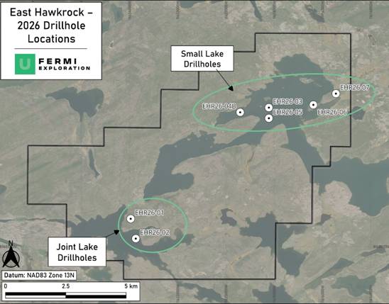
Figure 1 - Drill collar locations for the Winter 2026 programme on the East Hawkrock Property. Drill holes EHR26-04 and EHR26-04A are omitted; both terminated at shallow depths and share a collar location with EHR26-04B.
FURTHER INFORMATION
Technical Review
Although these first-pass exploratory holes did not encounter economic uranium mineralisation, and radioactivity was largely background; multiple critical factors indicative of a geological situation respective for unconformity related uranium elsewhere are observed from this first pass drilling programme.
The basal units of the Athabasca Sandstones themselves offer a source of porosity for late stage fluid movement; Holes such as EHR26-01 and EHR26-05 exhibit a transition into a basal conglomerate or coarse basal conglomerate unit containing larger pebbles (up to 2-3 cm). This basal unit represents a high-energy depositional environment directly overlying the palaeosurface, serving as a highly permeable regional aquifer for basinal fluids.1 This permeability and the potential for movement of uraniferous fluids is highlighted by the slight elevation in CPS readings of upto 120 CPS directly above or within the unconformity structure in holes EHR26-01, EHR26-03, EHR26-04B.
Furthermore, the presence of bleaching and hematite alteration is a common component of the alteration in the sandstones above unconformity related deposits. While the upper sandstones display pervasive diagenetic hematite, the basal 20 to 40 metres exhibit distinct hydrothermal overprinting.
Drillholes EHR26-02, EHR26-03, EHR26-04B, and EHR26-07 all record zones of strong, pervasive "brick-red" hydrothermal hematite alternating with zones of core bleaching. This indicates the passage of highly oxidising, acidic fluids-the primary transport mechanism for uranium.2 3
The property area has been established as an area of structural complexity, with highly deformed, strongly foliated pelitic and biotite gneisses were successfully intersected in drillholes EHR26-04B and EHR26-06. These metasedimentary units represent the primary structural targets in the basin, additionally, the presence of pyrite, which has been noted in EHR26-002, EHR26-004B, and EHR26-005 has acted as a reductant in other Athabascan Uranium Mineralisation Systems.4
However, the disseminated pyrite in amphibolite generated a false-positive for massive graphite in the Joint Lake Area, and while there is scope for such geology to host uranium, such geology is not as favourable as the target graphitic units. Additionally, the programme graphitic units are yet to be encountered in the Small Lake Area, suggesting these units are either absent, very thin, heavily fractured or overprinted with later alteration.
In summary, the maiden diamond drilling programme intersected encouraging geology consistent with established unconformity-related uranium systems within the Athabasca Basin. While these initial, first-pass holes did not intersect economic uranium mineralisation or highly elevated radiometric anomalies, the structural and hydrothermal framework identified retains promise. Further commentary on the property's prospectivity and future exploration vectors will be provided following a comprehensive analysis of the drilled geology and integrated geophysical data.
Appendix A: Table of Drill Collars on the East Hawkrock Property
Drill Hole ID | UTM Northing | UTM Easting | Elevation (m) | Downhole Depth (m) | Hole Azimuth | Hole Dip |
EHR26-01 | 6530268 | 533411 | 341.12 | 242.9 | 135 | -60 |
EHR26-02 | 6529853 | 533536 | 325.28 | 299 | 357 | -60 |
EHR26-03 | 6532679 | 536364 | 331.131 | 299 | 248 | -60 |
EHR26-04 | 6532573 | 535750 | 325 | 30.6 | 0 | -60 |
EHR26-04A | 6532573 | 535750 | 325 | 16.9 | 0 | -60 |
EHR26-04B | 6532573 | 535750 | 325 | 299 | 0 | -60 |
EHR26-05 | 6532452 | 536366 | 324.9 | 305 | 45 | -60 |
EHR26-06 | 6532747 | 537317 | 335.293 | 290 | 335 | -70 |
EHR26-07 | 6532992 | 537798 | 351.63 | 338 | 337 | -60 |
Table note: NAD83 Zone 13N, Hole Numbers EHR26-01, EHR26-04, EHR26-04A were abandoned before their target depths.
Table 1 : Drillhole Collar Locations from the 2026 Drilling Programme on the East Hawkrock Property
Appendix B: Drillhole Summaries
EHR26-01
Drillhole EHR26-01, which was planned as JL-C, was completed to a total downhole depth of 242.9 metres (210.4 metres true vertical depth), testing the overlying sedimentary sequence. Due to challenging drilling conditions, it did not intersect the unconformity, and thus the linear conductive feature at depth remains untested.
The sandstone intersected by EHR26-01 is characterised by dominant planar bedding and pervasive diagenetic hematite alteration. Encouragingly, core logging indicates the drillhole was approaching the highly prospective basal unconformity. From 235.4 metres downhole (203.9m TVD) to the end of the hole, there is a distinct increase in pebble size and frequency, marking a transition towards a basal conglomerate unit that overlies the basement and target conductive feature. This sedimentological shift is accompanied by moderate hematite alteration and a subtle but distinct elevation in background radioactivity, reaching up to 110 CPS.
While the regional unconformity and underlying metamorphic basement were not intersected within this specific interval, the lithological progression and positive radiometric signature at the base of the hole provide valuable structural vectoring data and confirm the fertility of the lower sedimentary package in this area.
EHR26-02
Drillhole EHR26-02, which was planned as JL-B, was successfully completed to a total downhole depth of 299.0 metres (258.9 metres true vertical depth), targeting an interpreted fold structure within the Joint Lake Area. Drilled at an inclination of -60 degrees, the hole successfully intersected the regional unconformity at 218.5 metres downhole (189.2 metres TVD) beneath a sequence of sandstone. Notably, the lower sandstone displayed pervasive hydrothermal hematite alteration and trace bleaching, indicating significant fluid movement.
Beneath the unconformity, the drillhole intersected a basement sequence of granitic gneiss and structurally deformed amphibolite. The basement exhibited strong palaeoweathering and structural weakness, including minor shearing and clay-chlorite-carbonate fault zones within the amphibolite, accompanied by up to 3% disseminated and fracture-hosted pyrite.
The presence of disseminated pyrite within the amphibolite is considered to be the source of the weak conductive anomaly, and while the structural complexity and alteration were welcomed, the lack of graphite associated with the amphibolite; and the structural continuity between the JL-B and JL-A targets, resulted in the cancellation of the planned JL-A drillhole.
EHR26-03
Drillhole EHR26-03, which was planned as SL-B, was successfully completed to a total downhole depth of 299.0 metres (258.9 metres true vertical depth). Drilled at an inclination of -60 degrees, the hole was designed to test a coincident gravity and magnetic low below Small Lake. This geophysical signature was interpreted to represent a principal structural corridor hosting graphitic metasedimentary units, further supported by its location within an area of anomalous radon.
The drillhole intersected the regional unconformity at 201.5 metres downhole (174.5 metres TVD) beneath a thick sandstone sequence. Encouragingly, the lower sandstone displayed clear signs of fluid movement, exhibiting intermittent bleaching and zones of strong, pervasive hydrothermal hematite alteration just above the unconformity. This was accompanied by a subtle elevation in background radioactivity, peaking at 120 counts per second (cps).
Beneath the unconformity, the hole intersected a structurally fractured basement sequence of granitic gneiss and pegmatite, rather than the targeted graphitic units. The uppermost basement features a pronounced, 24-metre-thick palaeoweathered profile with strong pervasive hematite, chlorite, and clay alteration.
While the specific graphitic source of the combined geophysical anomalies was not directly intersected, the presence of local fracturing, moderate folding, and hydrothermal alteration confirms an active structural setting.
EHR26-04, EHR216-04A and EHR26-04B
Due to challenging drilling, hole EHR26-04 was terminated at 30.6 m, with the follow-up hole EHR26-04A terminated at 16.9 m. Both of these holes terminated in the upper Athabascan Sandstones.
Drillhole EHR26-04B successfully tested the targeted geophysical anomalies, reaching a total depth of 299.0 metres (approximately 257.6m true vertical depth). Drilling penetrated the thick Athabascan Sandstone sequence before intersecting the unconformity at 207.5 metres. Encouragingly, the basal sandstone (186.0-203.0m) exhibits strong patchy hematite.
Beneath the unconformity, the hole intersected a highly deformed basement package of strongly foliated pelitic and biotite gneisses. This metasedimentary sequence is interpreted to explain the coincident conductive and magnetic low targets. This upper basement geology of pelitic and biotite gneisses features a pronounced palaeoweathered profile containing strong to intense, pervasive hematite, chlorite, and clay alteration extending down to 256.5 metres. Background radioactivity peaked slightly at 120 cps deep in the basement alongside trace disseminated pyrite.
EHR26-05
Drillhole EHR26-05 was completed to a total downhole depth of 305.0 metres (approximately 264.1 metres true vertical depth)). This drillhole was specifically designed to test for graphitic units, with a coincident gravity high interpreted to represent a deep-seated basement source implying significant structural control.
The drillhole penetrated a thick overlying sandstone sequence before intersecting the unconformity at 203.6 metres downhole (176.3m TVD). Encouragingly, the lower sandstone profile exhibits a progressive increase in alteration, transitioning from moderate to strong hematite. This basal sandstone unit returned distinctly elevated radioactivity ranging from 150 to 280 counts per second (cps) alongside trace bleaching. Beneath the unconformity, the drillhole intersected a 6.5-metre-thick sequence of strongly foliated, heavily weathered pelitic gneiss exhibiting moderate to strong hematite and chlorite alteration. Below this palaeoweathered profile, the basement transitioned into a thick sequence of relatively unaltered granitic gneiss. At depth (281.7 to 288.8 metres; 244-250.1 m TVD) EHR26-05 intersected dark garnet pelite with minor faulting and disseminated pyrite mineralisation.
EHR26-06
Drillhole EHR26-06 was completed to a total downhole depth of 290.0 metres (251.1 m TVD). This hole was specifically designed to test a strong basement Electromagnetic (EM) target situated within a structurally complex zone, interpreted to represent multiple linear structural trends.
The drillhole penetrated the overlying sandstone sequence, successfully intersecting the regional unconformity at 199.0 metres downhole (172.3m TVD). The lower sandstone profile had a zone of weak bleaching was recorded from 156.2 metres, which transitioned sharply into strong, pervasive hematite alteration extending directly down to the unconformity.
Beneath the unconformity, the drillhole successfully validated the structural interpretation by intersecting an alternating, highly deformed basement sequence. The basement is characterised by packages of strongly foliated pelitic gneisses (199.0m to 231.2m and 240.2m to 262.6m) interspersed with intervals of granitic gneiss. These pelitic metasediments exhibit strong tectonic foliation accompanied by moderate to strong pervasive chlorite, clay, and hematite alteration. No significant radioactivity was encountered.
EHR26-07
Drillhole EHR26-07 was successfully completed to a total downhole depth of 338.0 metres (approximately 286.7 metres true vertical depth, averaging a -58.0 degree inclination). Following 32.0 metres of overburden, the drillhole penetrated a thick sandstone sequence before intersecting the regional unconformity at 219.4 metres (186.1m TVD).
This hole, in additional the previously planned holes, was drilled to test an inferred gravity and magnetic low, and faulting associated with it. A sister hole was planned to the northwest, to test the conductive high and magnetic low, but was postponed due to warming weather causing ground instability risks.
The lower Athabasca Sandstones displayed clear evidence of significant fluid movement. The basal section (198.0m to 219.4m) featured strong to intense banded and pervasive hematite, alongside intermittent intervals of hydrothermal hematite and trace bleaching.
Notably, the unconformity itself is marked by a sharp, structurally faulted contact with strong, structurally controlled hematite-clay brecciation and alteration within a meter scale fault system. Beneath this fault structure, the basement comprises weakly foliated granitic gneiss. A pronounced, 53-metre-thick palaeoweathered profile extends below the unconformity, characterised by pervasive hematite, chlorite, and clay alteration before transitioning into fresh granite at 274.6 metres.
GLOSSARY
Term | Definition |
Basal Conglomerate | A coarse-grained sedimentary rock composed of rounded rock fragments (pebbles or cobbles) located at the very bottom (base) of a sedimentary basin. |
Basement Rock | The thick, ancient foundation of metamorphic and igneous rocks that forms the continental crust, sitting beneath younger sedimentary rock layers. |
Bleaching | The removal of colour-often the removal of red iron oxides-from rocks via chemical reduction during the passage of active hydrothermal fluids. |
cps (Counts Per Second) | A standard unit of measurement used to quantify the level of background radioactivity detected in the rock core. |
Diagenetic | Relating to the physical and chemical changes that occur as loose sediment is gradually compressed and cemented into solid sedimentary rock. |
Disseminated Pyrite | Fine particles of the sulphide mineral pyrite (iron sulphide) scattered diffusely throughout a rock body, rather than being concentrated in solid veins. |
Electromagnetic (EM) Anomaly | A zone identified by geophysical surveys where the rock conducts electricity better than surrounding areas, often indicating the presence of graphite, water, or sulphide minerals. |
Garnet Pelite / Pelitic Gneiss | A highly deformed metamorphic rock originally formed from fine-grained mudstones or siltstones, subjected to intense heat and pressure. |
Graphitic Units | Rock layers containing significant amounts of graphite (carbon), which act as strong electrical conductors and are key structural targets in uranium exploration. |
Hematite Alteration | The chemical modification of a rock resulting in the addition or formation of hematite (an iron oxide), typically turning the rock a distinct 'brick-red' colour. |
Hydrothermal Fluid | Hot, naturally occurring, mineral-rich water that circulates through faults and fractures in the Earth's crust, capable of transporting and depositing metals like uranium. |
Palaeoweathering Profile | A geological record of ancient weathering, that occurred on a land surface before it was subsequently buried by younger sediments. |
Petrographic | The detailed macroscopic and microscopic description and systematic classification of rocks and their mineral assemblages. |
Petrophysical | Relating to the physical and chemical properties of rocks and how they interact with fluids, often used to calibrate and refine regional geophysical models. |
SWIR (Short-Wave Infrared) | An analytical laboratory technique used to identify and map specific alteration minerals, particularly clays, based on how they absorb and reflect infrared light. |
True Vertical Depth (TVD) | The absolute vertical distance from the surface straight down to a specific point in a drillhole, as opposed to the total drilled length of a hole angled into the ground. |
Unconformity | A buried erosional surface separates two rock masses of significantly different ages, representing a gap in the geological record. These different rock types may have different properties, which can influence mineralising fluids in different ways. |
REFERENCES
1 Kyser, K., Hiatt, E., Renac, C., Durocher, K., Holk, G., & Deckart, K. (2000). Diagenetic fluids in paleo- and meso-Proterozoic sedimentary basins and their implications for long protracted fluid histories. In K. Kyser (Ed.), Fluids and Basin Evolution (Mineralogical Association of Canada Short Course Series, Vol. 28, pp. 225-262).
2 Jefferson, Charles W. & Thomas, David & Gandhi, S & Ramaekers, P & Delauney, G & Brisbin, D & Cutts, C & Portella, P & Olson, R. (2007). Unconformity-associated uranium deposits of the Athabasca Basin, Saskatchewan and Alberta.
3 Hoeve, J., & Quirt, D. (1984). Mineralization and alteration associated with the unconformity-type uranium deposits in Saskatchewan. In Proterozoic Unconformity and Stratabound Uranium Deposits (pp. 103-121). IAEA.
4 Alexandre, P., Kyser, K., Polito, P., & Thomas, D. (2005). Alteration mineralogy and stable isotope geochemistry of Paleoproterozoic basement-hosted unconformity-type uranium deposits in the Athabasca Basin, Canada. Economic Geology, 100(8), 1547-1563.
QUALIFIED PERSON STATEMENT
The technical information contained in this disclosure has been read and approved by Mr Nick O'Reilly (MSc, DIC, MIMMM QMR, MAusIMM, FGS), who is a qualified geologist and acts as the Qualified Person under the AIM Rules - Note for Mining and Oil & Gas Companies. Mr O'Reilly is a Principal consultant working for Mining Analyst Consulting Ltd which has been retained by Power Metal Resources PLC to provide technical support.
This announcement contains inside information for the purposes of Article 7 of the Market Abuse Regulation (EU) 596/2014 as it forms part of UK domestic law by virtue of the European Union (Withdrawal) Act 2018 ("MAR"), and is disclosed in accordance with the Company's obligations under Article 17 of MAR.
For further information please visit https://www.powermetalresources.com/ or contact:
Power Metal Resources plc | |
Sean Wade (Chief Executive Officer)
| +44 (0) 20 3778 1396 |
SP Angel Corporate Finance LLP (Nomad and Joint Broker) | |
Ewan Leggat/Jen Clarke
| +44 (0) 20 3470 0470 |
Tamesis Partners LLP (Joint Broker) | |
Richard Greenfield/Charlie Bendon | +44 (0) 20 3882 2868 |
BlytheRay (PR Advisors) Tim Blythe/Megan Ray/Alastair Roberts |
+44 (0) 20 7138 3204 |
NOTES TO EDITORS
Power Metal Resources plc - Background
Power Metal Resources plc (AIM: POW, OTCQB: POWMF) is a London-listed metals exploration company which finances and manages global resource projects and is seeking large scale metal discoveries.
The Company has a principal focus on opportunities offering district scale potential across a global portfolio including precious, base and strategic metal exploration in North America, Africa, Saudi Arabia, Oman and Australia.
Project interests range from early-stage greenfield exploration to later-stage prospects currently subject to drill programmes.
Power Metal will develop projects internally or through strategic joint ventures until a project becomes ready for disposal through outright sale or separate listing on a recognised stock exchange thereby crystallising the value generated from our internal exploration and development work.
Value generated through disposals will be deployed internally to drive the Company's growth or may be returned to shareholders through share buy backs, dividends or in-specie distributions of assets.
Related Shares:
Power Metal Resources PLC