20th Oct 2025 07:00
NOT FOR RELEASE, PUBLICATION OR DISTRIBUTION IN WHOLE OR IN PART IN, INTO OR FROM THE UNITED STATES OR ANY JURISDICTION WHERE TO DO SO WOULD CONSTITUTE A VIOLATION OF THE RELEVANT LAWS OR REGULATIONS OF THAT JURISDICTION.
20 October 2025
First Development Resources plc
('First Development", "FDR" or the "Company')
Selta Project - Gold exploration strategy
First Development Resources plc (AIM: FDR) the UK based, Australia focused exploration company with mineral interests in Western Australia and the Northern Territory, is pleased to provide an update in respect of its gold ("Au") exploration strategy at its Selta Project ("Selta" or the "Project") located in the in the Aileron Province of Australia's Northern Territory.
HIGHLIGHTS
· Multiple prospective gold targets identified at FDR's Selta Project in Australia's Northern Territory.
· Gold targets associated with the continuation of the regionally significant Stafford Gold Trend which hosts gold and high-grade antimony ("Sb") to the south.
· Systematic and methodical exploration strategy planned to include geophysical high-resolution airborne magnetic ("AMAG") and ground based gradient array induced polarisation ("GAIP") surveying to refine targets ahead of Reverse Circulation ("RC") drilling programme.
· Fieldwork expected to commence Q4 2025.
Following a review of historical mineral exploration reports and data, Western Australian based consultants Resource Potentials Pty Ltd ("ResPot") has identified multiple gold targets within the Selta project area and has provided recommendations for immediate exploration to develop the targets further.
ResPot has developed a series of recommendations for Au exploration in the western part of the Selta project tenements, including additional geophysical surveying and RC drilling. The Company is now further refining the drill targets through a high-resolution AMAG survey with a view to implementing an RC drilling campaign following the conclusion of the wet season in late Q1 to early Q2 2026. The results of the AMAG survey will also be used to plan air-core drilling across well-defined gold target trends extending from two key gold trends that extend below a thin layer of young sedimentary cover to the east.
Tristan Pottas, Chief Executive Officer of FDR, commented:
"With multiple gold exploration targets already identified at Selta, we are excited by the opportunity this study has highlighted through detailed assessment of historical drilling, geochemical and geophysical survey results. Over the coming weeks, the Company will expedite a high-resolution AMAG survey to help refine drilling on the gold targets identified at Selta to move these targets to a drill ready status at the earliest opportunity. The budget for this work is in line with the Company's exploration plan set out in FDR's Admission Document.
This work focuses on the Selta's prospectivity for gold, and there remains scope in the future for expanding our exploration across Selta for other minerals in the eastern part of the Project area, such as lithium and rare-earth elements. In parallel to this work, we will continue to assess the learnings from our recent deep drilling at the Company's Wallal project and evaluate further targets and any requisite permissions with a view to resuming drill work when practicable in 2026."
SELTA PROJECT BACKGROUND
The Selta project area is considered highly prospective for hosting economic deposits of gold, but also antimony, copper ("Cu"), rare-earth elements ("REE"), hard rock lithium ("Li", as spodumene in pegmatites), paleochannel uranium ("U"), skarn related tin ("Sn") and other metallic elements as discussed in FDR's Admission Document. Selta is located directly along strike and 100 kilometres ("km") to the north-west of the Arafura Rare Earths Limited (ASX: ARU) world-class Nolans REE-phosphorus-uranium deposit and mine development project, and along the northern extents of the Stafford Gold Trend currently being explored by iTech Minerals (ASX: ITM) adjacent to FDR's tenements forming the Selta Project.
The regional geology of the Selta Project area consists of multiple phases of Proterozoic granite and granulite, metasedimentary and volcanic units and domains which underwent multiple periods of deformation and metamorphism to form greenstone-gneiss belts. Some of the granites are highly radiogenic and the moderate to high-grade metasedimentary units consist mainly of shales, volcaniclastics, carbonates and conglomerates of the Lander Rocks Beds and Pine Hill Formation, with domains of mixed sediments and volcanics and mafic-ultramafic volcanic units, which are locally prospective for hosting intrusive related gold ("IRG") style deposits and volcanic hosted massive sulphide ("VMS") style base metal deposits. These greenstone units were intruded by 1550-1510 millions years ago ("Ma") pegmatites and monazites, which include apatite veins that host the REE-P-U mineralisation at the nearby ARU's Nolans project. Large parts of the Selta Project area are covered by modern drainage systems and thin transported sediment deposits in low-lying areas, with a thicker sedimentary basin in the northwest part of the Project area that was the focus of historical paleochannel style U exploration.
SELTA PROJECT GOLD TARGETING STUDY
FDR commissioned ResPot to review available historical exploration data at the Selta Project, including compiling, re-processing and integrating drilling, geological, geophysical and geochemical datasets, to identify gold targets within the Project area and to provide recommendations for future gold exploration work.
Historical geochemical sampling and drilling in the regional area has identified multiple gold prospect areas forming well defined linear trends extending for over 5km in length. Previous exploration for gold at Selta has been limited to sparse areas of outcropping mineral host rocks surrounded by a thin layer of young sedimentary cover, with comparatively few deep drillholes penetrating into the bedrock which forms the host to gold mineralisation (see Figure 1). Historically ineffective methods for modern exploration have been applied, with the vast majority of drill 'testing' on Selta being by very shallow vacuum drilling (Figure 2), which was mostly unable to penetrate into the solid geology where auriferous mineralisation is potentially located.
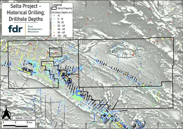
Figure 1: Map of the Selta Project tenements showing drillhole collar locations coloured by drillhole depth (coloured dots), over a regional greyscale magnetic derivative image (TMIRTP 1VDAGC). Note that the vast majority of historical drillholes inside of FDR's Selta project tenements are less than 40m deep, which is considered to be ineffective by modern gold exploration standards in this type of geological setting, and many of the deeper holes were only assayed for uranium.
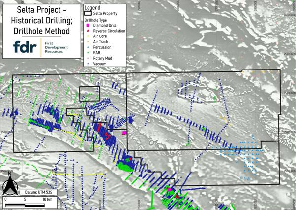
Figure 2: Map of the Selta Project tenements showing drillhole collar locations coloured by drillhole type (coloured dots), over a regional greyscale magnetic derivative image (TMIRTP 1VDAGC). Note that the vast majority of drilling is by very shallow vacuum drilling which usually did not penetrate through the younger sediment layer sitting above the target bedrock.
ResPot has reviewed available geological, geochemical and geophysical datasets over the Selta Project regional area to identify a large buried granite located just to the north of the western gold anomaly trends, where the gold and associated element pathfinder anomalies (Cu, As, Ag, Sb and Bi) form two 5km long corridors following interpreted shear zones in the metasediment-volcanic units that have been very poorly explored in the past. These structural trends can be seen in magnetic anomaly images to continue under young sediments where there has been no effective exploration drilling and are therefore blind gold target trends. The Company presently considers the western part of the Selta tenements to be the most prospective for hosting intrusion related Au mineralisation and it will form the initial exploration focus (see Figures 3 to 5).
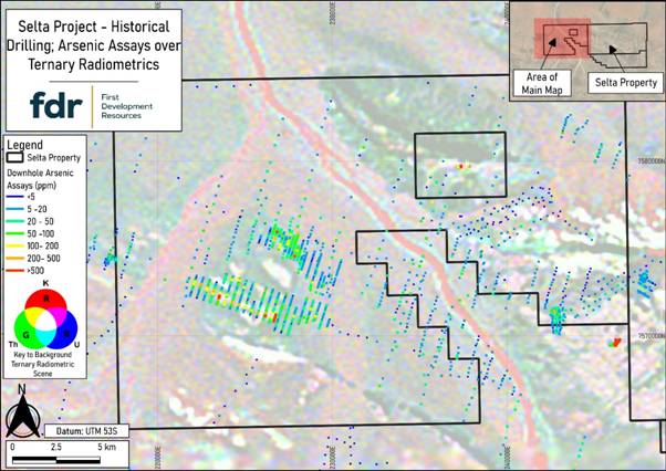
Figure 3: Zoomed-in map of the western part of the Selta Project showing drillhole traces projected to surface and coloured by As assays (coloured lines), over a ternary radiometric red-green-blue combination image (K²-Th²-U² 1VD rgb). Note that the well-defined trends of arsenic ("As") anomalism in drilling are over 5km long and form a prominent anomaly halo surrounding a trend of weak shallow Au anomalism as shown in Figure 4, with no effective drilling to the east of these trends where there is younger sediment cover in this poorly explored Project area.
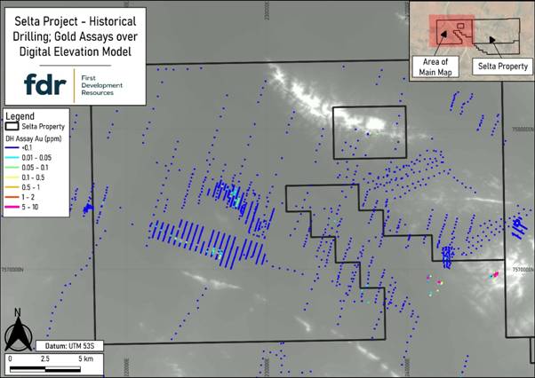
Figure 4: Zoomed-in map of the western part of the Selta Project showing drillhole traces projected to surface and coloured by Au assays (coloured lines), over a greyscale derivative digital elevation model ("DEM") image (GLO30 DEM 1VD). Note the weak but well-defined Au anomaly tends in the shallow drilling, and where higher grades only occur where the drilling is a little deeper, defining two large corridors for follow-up RC drilling into the fresh host rock, and with potential for step out air-core drilling following these trends under shallow sedimentary cover along geological strike to the east.
Concentrations of different pathfinder elements related to gold mineralisation (such as Cu, As, Sb, Ag and Bi), were plotted and reviewed in Geographic Information System ("GIS") software with other available exploration datasets. Suites of geophysical survey imagery, including magnetics, radiometric and digital elevation model ("DEM") images, were integrated with drilling and geochemical sampling data to interpret relevant shear-controlled gold trends and fold related structures, which are both favourable sites for targeting Au mineralisation and planning immediate follow-up detailed geophysical surveying and drilling (see Figure 5).
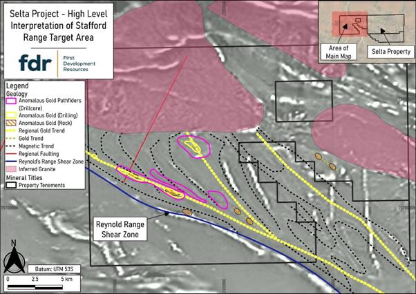
Figure 5: Zoomed-in map of western the western Selta area showing high-level interpretation of the Stafford Range gold target region over a magnetic anomaly image. Note the affinity of identified gold and gold pathfinder geochemical anomaly trends with significant shearing within the metasediment-volcanic units, and a large granitic intrusion to the north (pink area) interpreted to be buried under younger sediments and which may have been a source for heat and hydrothermal fluids related to gold mineralisation.
A major shear zone, the Reynold's Range shear zone (Figure 5: blue line), is considered to be the southwest boundary of the prospective gold mineralisation corridor of the Stafford Gold Trend.
A series of magnetic unit trends (dashed black lines) were drawn to help interpret the strike of the bedrock geology, including fold axes and hinges, which are also structures prospective for hosting gold mineralisation. A series of younger magnetic mafic dykes have cut through the area and overprinted the more subtle magnetic unit trends, making interpretation more difficult using the existing lower resolution AMAG survey data.
Trends of regional and local anomalous gold concentrations were traced out (dashed yellow lines), and these gold trends are interpreted to be the northwest extents of the Stafford Gold Trend which runs through the iTech ground to the south-east. At least two of these regional interpretated gold trends extend onto the western part of FDR's tenements and are considered to be the main gold target trends in the Project, with extensions of gold trends hidden below shallow sediment cover that remain untested to the east, but could be tested later using lines of air-core drilling extending to fresh bedrock.
Large granitic intrusions (shaded pink areas) were interpreted in the area from magnetic anomaly patterns, and these granites are considered to be prospective heat engines and sources of hydrothermal fluids for driving gold mineralisation into shears and fold structures to the south.
RECOMMENDED EXPLORATION STRATEGY
Based on the interpretation lines shown in Figure 5, and the 5km strike-extensive anomalous Au and pathfinder element trends identified by shallow penetrating historical drilling, ResPot has developed a series of recommendations for Au exploration at the western part of the Selta project tenements, including additional geophysical surveying and focussed RC drilling.
High-resolution AMAG surveying is now planned to be carried out over the prospective Au corridors within the Selta tenements, as highlighted by the blue outline on Figure 6. The AMAG survey will help delineate structural features and hydrothermal alteration zones within the metasediment-volcanic host bedrock, providing high-resolution anomaly image detail to support interpretation of potential gold mineralised trends and structures for drill testing. The AMAG survey is currently being tendered to be completed using a low-flying fixed-wing aircraft with survey lines spaced at along 50m intervals, compared to the existing 200m AMAG survey line spacing.
Gradient array induced polarisation surveying has been planned over four survey blocks (light orange hashed blocks Figure 6), each measuring approximately 2km x 1.5km, and located over anomalous Au and pathfinder element concentrations intersected from historical drilling and anomalous rock-chip sample results. The GAIP surveying will acquire electrical resistivity data that can help map subsurface geology and structures, and chargeability data to map anomalies potentially related to disseminated sulphide minerals related to gold alteration systems and sources for the pathfinder elements which form sulphide minerals in the fresh bedrock. The GAIP, and potential survey lines of dipole-dipole IP across anomalies to get depth extents, will be integrated into a three-dimensional targeting workspace with magnetic inversion model results and drilling data to provide robust targets for planning RC drilling into key gold targets.
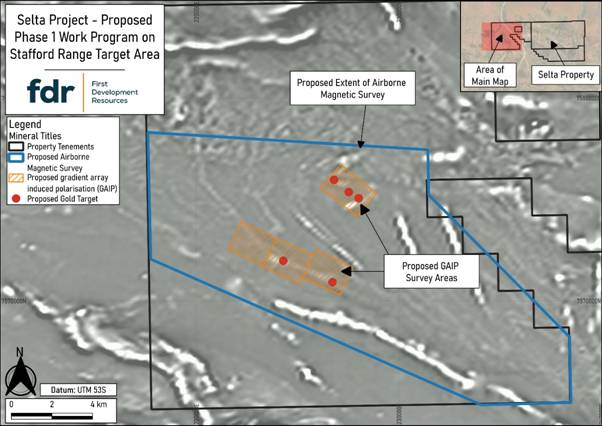
Figure 6: Map of the western Selta area showing proposed Phase 1 Work Programme on the Stafford Range gold target areas, over a magnetic anomaly image, to highlight the planned AMAG and GAIP survey area locations.
QUALIFIED PERSON STATEMENT
The technical information contained in this disclosure has been reviewed and approved by Mr Nicholas O'Reilly (MSc, DIC, MIMMM QMR, MAusIMM, FGS), who is a qualified geologist and acts as the Qualified Person under the AIM Rules - Note for Mining and Oil & Gas Companies. Mr O'Reilly is a principal consultant working for Mining Analyst Consulting Ltd which has been retained by First Development Resources plc to provide technical support.
GLOSSARY OF TERMS
"Ag" | silver |
"air core drilling" | Aircore drilling, also known as air percussion drilling, is a method of drilling that utilizes compressed air to drive cutting tools and extract soil and rock samples from the ground. |
"AMAG" | An aeromagnetic ("AMAG") survey is a geophysical survey method that uses a magnetometer mounted on an aircraft to measure variations in the Earth's magnetic field, aiding in geological mapping and mineral exploration. |
"apatite veins" | Apatite is a very common early-formed accessory mineral in nearly all type of igneous rocks. Apatite is also concentrated by late magmatic segregation, and it appears in granite pegmatite. |
"As" | arsenic |
"Au" | gold |
"auriferous" | Containing or bearing gold, especially in rock. |
"Bi" | bismuth |
"Cu" | copper |
"DEM" | Digital elevation model |
"Dipole to dipole induced polarisation" | The dipole-dipole array is a method used in geophysical exploration to measure the apparent resistivity of the earth's subsurface. |
"GAIP" | A ground based gradient array induced polarisation ("GAIP") survey. A GAIP survey is a geophysical survey technique that utilizes Gradient Array Induced Polarisation to gather data on the subsurface characteristics of materials. This method is particularly useful in identifying potential mineralization, such as gold, copper, uranium, and other valuable resources. The survey involves the use of electrodes and receivers to measure the chargeability and resistivity of the subsurface materials, providing insights into the presence and distribution of minerals. GAIP surveys are widely used in the mining and exploration industries to assist in the planning and targeting of drilling activities. |
"GIS" | GIS, or Geographic Information System, is a technology used to create, manage, analyse, and map various types of data. It connects location data (where things are) with descriptive information (what things are like there), allowing for the visualization and analysis of geospatial data. |
"gold pathfinder geochemical anomaly trends" | Gold pathfinder geochemical anomaly trends are characterised by the presence of specific elements and minerals that indicate the potential for gold mineralisation. These anomalies are often associated with hydrothermal systems and can be detected through geochemical surveys, geophysical methods, drilling and core logging. Key pathfinders for gold include arsenic ("As"), antimony ("Sb"), mercury ("Hg"), silver ("Ag"), copper ("Cu"), lead ("Pb") and zinc ("Zn"). These elements form geochemical halos that extend beyond the gold mineralisation zone, making them easier to detect and indicating the presence of gold deposits. |
"IRG" | Intrusion-related gold ("IRG"). Intrusion-related gold deposits are significant sources of gold, characterised by their association with magmatic intrusions and unique geological features. |
"km" | kilometres |
"Lander Rocks Beds" | A geological unit local to the Selta Project. |
"Li" | lithium |
"Ma" | In geology, "Ma" stands for "million years ago" (megaannum). It is a unit of time used to indicate how many millions of years prior to the present an event occurred. |
"mafic-ultramafic volcanic units" | Igneous rocks can be classified based on their chemical and mineral composition into four primary categories: ultramafic, mafic, intermediate, and felsic. |
"magnetic mafic dykes" | A magnetic mafic dyke is a type of volcanic intrusion characterized by its magnetic properties, which can provide insights into the magma flow and source mechanisms. |
"metasediment-volcanic units" | Metasediment-volcanic units are geological formations that consist of both metasedimentary and volcanic rocks. These units are formed when volcanic rock, either as lava or tephra, is subjected to high pressure and temperature, causing the original volcanic rock to recrystallize. This metamorphism can occur through processes such as burial under younger rocks or exposure to high temperatures. The resulting metasedimentary rocks can include minerals such as mica, garnet, and aluminosilicates, and they may exhibit foliation and banding due to the recrystallization process. Metasediment-volcanic units are commonly found in greenstone belts and are significant in understanding the geological history and processes of the Earth's crust. |
"monazite" | Monzonite is an igneous intrusive rock that forms from slow cooling of underground magma. It has a moderate silica content and is enriched in alkali metal oxides. Monzonite is composed mostly of plagioclase and alkali feldspar. |
"paleochannel style exploration" | Paleochannel style exploration involves the study and mapping of ancient river systems, often referred to as paleochannels. These channels are significant because they can provide insights into past hydrology, climate, and geological processes. |
"pegmatites" | Pegmatites are a type of igneous rock that form during the final stage of a magma's crystallization. They are characterized by exceptionally large crystals, typically greater than 1 cm, and often contain minerals that are rare in other rock types. Most pegmatites are composed of quartz, feldspar, and mica, and they can exhibit a very coarse texture with large interlocking crystals. |
"Pine Hill Formation" | A geological unit local to the Selta Project. |
"RC" | Reverse Circulation ("RC") drilling is a percussion-based drilling technique primarily used in mining and mineral exploration. It employs a dual-walled drill pipe system, where compressed air is pumped down the outer tube and rock cuttings are brought back up through the inner tube. This method is favored for its ability to produce dry, uncontaminated samples quickly and efficiently, making it ideal for assessing mineral content at various depths, typically up to 500 meters. |
"REE" | rare-earth elements |
"REE-P-U" | rare-earths-phosphate-uranium |
"Sb" | antimony |
"Sn" | tin |
"Stafford Gold Trend" | The Stafford gold trend is a gold trend local to the Selta Project area. A gold trend in geology refers to the geological processes that lead to the formation of gold deposits. These processes are influenced by tectonic activity, chemical reactions, and hydrothermal systems. |
"U" | uranium |
"vacuum drilling" | Vacuum drilling exploration is a method of drilling that utilizes a vacuum system to remove soil and debris from the ground, allowing for efficient sample recovery. |
"VMS" | Volcanogenic Massive Sulfide ("VMS") deposits are significant sources of metals like copper, zinc, lead, gold, and silver, formed through volcanic and hydrothermal processes on or below the seafloor. |
For further information visit www.firstdevelopmentresources.com or contact the following:
First Development Resources plc Tristan Pottas (CEO) | Tel: +44 (0) 20 3778 1397 |
Beaumont Cornish Limited Nominated Adviser Roland Cornish / Asia Szusciak | Tel: +44 (0) 20 7628 3396 |
SI Capital Limited Broker Nick Emerson | Tel: +44 (0) 1483 413 500 |
Beaumont Cornish Limited ("Beaumont Cornish") is the Company's Nominated Adviser and is authorised and regulated by the FCA. Beaumont Cornish's responsibilities as the Company's Nominated Adviser, including a responsibility to advise and guide the Company on its responsibilities under the AIM Rules for Companies and AIM Rules for Nominated Advisers, are owed solely to the London Stock Exchange. Beaumont Cornish is not acting for and will not be responsible to any other persons for providing protections afforded to customers of Beaumont Cornish nor for advising them in relation to the proposed arrangements described in this announcement or any matter referred to in it.
ABOUT FIRST DEVELOPMENT RESOURCES
First Development Resources' assets comprise eight granted tenements covering a total area of 2,314.4km2. Five of the tenements, comprising three prospective copper-gold projects, are located in Western Australia (WA) while the remaining three tenements, comprising a rare-earth element (REE), uranium, lithium and gold project, are located in the Australian's Northern Territory. All tenements are wholly owned by FDR. The assets are a mixture of drill ready and earlier stage exploration.
The Selta Project in the Northern Territory is located in an area considered highly prospective for uranium and rare-earth element mineralisation along with base and precious metal mineralisation. Numerous companies are actively exploring within the region.
The WA Projects include the Company's Wallal Project as well as Ripon Hills and Braeside West Projects situated in the Paterson Province, which is widely regarded as one of the most productive regions in Australia for the discovery of world-class gold-copper deposits, and which is home to several world-class mines and more recent discoveries.
Beyond the existing portfolio, FDR is actively looking to expand its portfolio through the acquisition of early-stage exploration projects in Australia.
Related Shares:
First Development Resources