28th Apr 2025 07:00
The information contained within this announcement is deemed to constitute inside information as stipulated under the Market Abuse Regulation ("MAR") (EU) No. 596/2014, as incorporated into UK law by the European Union (Withdrawal) Act 2018. Upon the publication of this announcement, this inside information is now considered to be in the public domain.
Phase One Drilling Update
Artemis Resources Limited ("Artemis" or "the Company") (ASX/AIM: ARV) is pleased to announce results from the first phase of drilling of three gold targets in the immediate area of the 100% owned Carlow gold/copper resource[1]. Phase One comprised five diamond holes for a total of 1,790m with details of the targets included in Artemis announcements on 10 February and 19 March 2025.
With the current gold price (~USD3,300/oz) approximately double the price when the Carlow Mineral Resource was announced in October 2022[2] (~USD1,640/oz), Artemis has commenced a review of >400 historic drill holes which formed the basis of the 2022 resource. Early results from this review are encouraging and some initial findings are summarised in this announcement.
Highlights - Phase One Drilling
· 7m @ 2.9g/t Au including 1m @ 15.3g/t Au from 404m in 25ARDD001, the first hole to test the Marillion Prospect, 600m east of the Carlow resource
· Marillion may be an extension of the Carlow gold/copper lode system, with the 600m gap between Carlow and Marillion now a high priority for drilling
· 1m @ 16.4g/t Au from 67m intersected at Titan, in hole 25ARDD004, 1.5km west of Carlow and on the same interpreted structure which hosts Carlow and Marillion
· Titan intersection supported by elevated gold assays up to 0.5g/t Au within previously untested sequence intruded by porphyry with strong alteration, veining, brecciation
· Phase One drilling generates new interpretation of Carlow geological setting opening up wider potential for mineralisation. Planning next phase of drilling in June
Highlights - Carlow Review
· 192 high-grade gold assays (>10g/t Au) intersected in 80 historic holes at Carlow[3] identified during initial stage of the Carlow review
· 515 high-grade copper assays (>2.0% Cu) intersected in 162 historic holes at Carlow[4] identified during initial stage of the Carlow review
· Deepest historic hole at Carlow intersected 4m @ 11.1 g/t Au & 2.0% Cu, outside the resource with potential completely open below and along strike
· Conceptual technical studies of Carlow including metallurgical test work are likely next steps pending completion of the Carlow review
Julian Hanna, Managing Director, commented:
"I am pleased to report very encouraging results from the drilling program designed as an initial test of three previously undrilled gold targets near Carlow and to scope out the potential for significant extensions to the known gold/copper lode system at Carlow.[5] The program was successful in intersecting high-grade gold at two of the targets and providing compelling support for potential new discoveries and possible extensions to the Carlow deposit.
Highlights from the drilling include high-grade gold (>15g/t Au) intersected at the Marillion and Titan targets located 2.7km apart on the same structural zone which hosts the 374koz gold and 66,000t copper resource at Carlow. Importantly the first drill hole at the large Marillion target intersected 7m @ 2.9g/t Au including 1m @ 15.3g/t Au from 399m downhole in 25ARDD001, approximately 600m east along strike from any previous drilling at Carlow. This one intersection suggests gold mineralisation may extend well beyond the current deposit with the gap between Carlow and Marillion now a high priority for drilling planned to start in the June quarter.
The potential for extensions to the Carlow deposit is also supported by an intersection of 4m @ 11.1 g/t Au and 2.0% Cu in hole 20CCDD003, the deepest historic drill hole at Carlow[6]. This intersection is at approximately 500m vertical depth and is not included in the Carlow resource. The high-grade intersection in hole 20CCDD003 warrants step out drilling to test for other high-grade gold and copper lodes and potential resource extensions below Carlow.
The three recent holes at Titan were drilled below one of four surface gold occurrences in quartz veins and chert outcrops around a central gravity-low feature reported in 2024 and 2025[7]. The holes intersected ultramafic rocks and sediments intruded by porphyry with elevated values of gold up to 0.5g/t Au intersected in the ultramafic sequence and 1m @ 16.4g/t Au intersected in the porphyry intrusion in hole 25ARDD004 from 67m down hole.
The first step in the Carlow review is to evaluate numerous (>700) high-grade gold and copper assays from historic drilling. High gold and copper grades are widespread across the Carlow lode system with assays greater than 10g/t gold and 2.0% copper listed in Tables 1-4 and plotted on Figure 1 below. Depending on the initial review we expect to appoint consultants to undertake conceptual technical studies including metallurgical test work on drill core samples from Carlow. We look forward to updating shareholders in coming weeks on the planned follow-up drilling as well as progress on the review of the Carlow gold/copper deposit at this exciting project".

|
Figure 1: Schematic longitudinal section extending from Marillion to Titan showing main interpreted geological features, an outline of the current Inferred Mineral Resource[8] at Carlow, pierce points of high-grade gold (>10g/t Au) and copper (>2.0% Cu) assays[9] projected onto the section and drill traces (red) of all recent Phase One drill holes
Drilling Summary
1. Marillion Hole - 25ARDD001
Hole 25ARDD001 was drilled through the Andover Intrusion which occurs as a layered sill comprising gabbro, leuco-gabbro and pyroxenite with a relatively flat lying brecciated basal contact. Underlying the intrusion is a ~300m wide sequence of pillow basalts and local interflow sediments, with localised brecciation and sulphides. Gold mineralisation intersected in 25ARDD001 (7m @ 2.9g/t Au including 1m @ 15.3g/t Au from 399m downhole) is associated with a zone of quartz/sulphide veins in basalt, which is the main host rock at Carlow.
Underlying the basalt, 25ARDD001 intersected a sequence of shallow dipping sediments and cherts containing abundant sulphide which is the likely source of the Marillion electromagnetic anomaly[10] The chert/sediment sequence is interpreted to be a shallow dipping equivalent of the Regal Thrust which outcrops as prominent ridges of steep south dipping chert units forming an arc to the west and north of Carlow. 25ARDD001was terminated at 714.6m in sediments.
2. Carlow Extension Hole - 25ARDD002
Hole 25ARDD002 was drilled 100m east of the Carlow resource and intersected a similar sequence as drilled in 25ARDD001. The main target of 25ARDD002 was the potential for a down plunge extension to one of the Carlow lodes. 25ARDD002 reached the target depth which was intruded by a later gabbro dyke (probably related to the Andover Intrusion) and the hole failed to intersect gold mineralisation. A deeper copper intersection of 2.5m @ 0.87% Cu from 478.0m downhole in 25ARDD002 was intersected in sediments below the gold target depth.
3. Titan Holes - 25ARDD003, 25ARDD004, 25ARDD005
Three holes were drilled along a section as an initial test of a surface gold occurrence hosted by west dipping quartz/ironstone veins exposed in shallow pits on the eastern side of Titan. Previous selective sampling of the veins returned very high-grade gold and silver assays[11] Holes 25ARDD003, 25ARDD004, 25ARDD005 intersected a chrome rich ultramafic sequence overlying strongly altered, veined and brecciated sediments intruded by porphyry dyke. Elevated gold values up to 0.5g/t Au were intersected in the ultramafic sequence and porphyry and 1m @ 16.4g/t Au was intersected in the porphyry in hole 25ARDD004 from 67m down hole. (Refer to Figure 2)

Figure 2: Titan cross section showing elevated gold intersections including 1m @ 16.4g/t Au hosted in porphyry
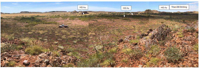
Figure 3: View from a chert ridge (part of Regal Thrust) looking northeast across Titan central gravity low feature. Showing approximate location of recent Titan drill holes (25ARDD003, 25ARDD004, 25ARDD005 - refer to Figure 2)

Figure 4: Satellite image of eastern part of the Carlow Tenement (red) showing outline of Carlow Resource 2022, and location of the 5 diamond drill holes completed in the Phase One drilling program
This announcement was approved for release by the Board. For further information
|
Tel: +44 20 3829 5000
|
Qualified Person Statement
The information in this report that relates to Exploration Results was compiled by Mr Julian Hanna, a Competent Person who is a member of the Australasian Institute of Mining and Metallurgy (MAusIMM). Mr Hanna is Managing Director of Artemis Resources Ltd and has sufficient experience that is relevant to the style of mineralisation and type of deposit under consideration and to the activity being undertaken to qualify as a Competent Person as defined in the 2012 Edition of the 'Australasian Code for Reporting of Exploration Results, Mineral Resources and Ore Reserves". Mr Hanna consents to the inclusion in this report of the matters based on his information in the form and context in which it appears.
No New Information
To the extent that this announcement contains references to prior exploration results which have been cross referenced to previous market announcements made by the Company, unless explicitly stated, no new information is contained. The Company confirms that it is not aware of any new information or data that materially affects the information included in the relevant market announcements and, in the case of estimates of Mineral Resources, that all material assumptions and technical parameters underpinning the estimates in the relevant market announcements continue to apply and have not materially changed.
About Artemis Resources
Artemis Resources (ASX/AIM:ARV) is a gold, copper and lithium focused resources company with a highly attractive suite of projects in Western Australia's underexplored North Pilbara Gold Province.
· Attractive projects:
o Gold/Copper - Karratha Gold Project (100%) multiple prospects incl: Carlow, Titan, Marillion
o Paterson Gold/Copper Project - adjacent to Havieron Mine (owned Greatland Gold)
o Lithium - Artemis/Greentech Lithium JV: Mt Marie, Kobe, Osborne
· Highly strategic location: Tier 1 jurisdiction, close proximity to major hub at Karratha including regional rail and road infrastructure, administrative centre and Dampier Port
· Significant exploration upside: highly prospective tenure package in the Pilbara Region of Western Australia which is rapidly emerging gold province dominated by >12Moz Au Hemi Project
· Mineral Resource with growth potential: existing high-grade gold-copper-cobalt Inferred Mineral Resource at Carlow (100%-owned tenure)
· Established processing site at Radio Hill: strategically located, fully permitted
· IOCG Exploration Target: Artemis has applied for a 340km2 exploration licence 440km east of Kalgoorlie covering a large interpreted magnetic intrusion prospective for IOCG type copper/gold
APPENDIX
Project | HoleID | Easting | Northing | Grid | Azi | Dip | EOH |
Carlow East | 25ARDD002 | 507832 | 7698267 | GDA94 MGA zone 50 | 340 | -50 | 527.4 |
Marillion | 25ARDD001 | 508346 | 7698466 | GDA94 MGA zone 50 | 0 | -70 | 714.6 |
Titan East | 25ARDD003 | 505827 | 7699444 | GDA94 MGA zone 50 | 45 | -50 | 148.4 |
Titan East | 25ARDD004 | 505812 | 7699429 | GDA94 MGA zone 50 | 45 | -65 | 162.5 |
Titan East | 25ARDD005 | 505783 | 7699400 | GDA94 MGA zone 50 | 45 | -70 | 237.3 |
Drill hole parameters for five holes completed in the Phase One drill program
Hole ID | Comments | From (m) | To (m) | Interval (m) | Au (g/t) | Cu (%) |
25ARDD001 |
| 399 | 400 | 1 | 1.98 | 0.4 |
25ARDD001 |
| 400 | 401 | 1 | 0.04 | 0.1 |
25ARDD001 |
| 401 | 402 | 1 | 1.71 | 0.8 |
25ARDD001 |
| 402 | 403 | 1 | 0.22 | 0.2 |
25ARDD001 |
| 403 | 404 | 1 | 0.15 | 0.1 |
25ARDD001 |
| 404 | 405 | 1 | 15.35 | 0.0 |
25ARDD001 |
| 405 | 406 | 1 | 0.85 | 0.1 |
25ARDD002 |
| 426.2 | 427 | 0.8 | 0.5 | 0.0 |
25ARDD002 |
| 478 | 479 | 1 | 0.6 | 0.5 |
25ARDD002 |
| 479 | 479.4 | 0.4 | 0.07 | 0.1 |
25ARDD002 |
| 479.4 | 480 | 0.6 | 0.22 | 0.4 |
25ARDD002 |
| 480 | 480.5 | 0.5 | 0.48 | 2.5 |
25ARDD003 | NSI |
|
|
|
|
|
25ARDD004 |
| 67 | 68 | 1 | 16.4 | 0.1 |
25ARDD005 | NSI |
|
|
|
|
|
Assay results in Phase One drill holes using 0.5g/t gold cut and 0.5% copper cut
Table 1 - gold assays >10g/t Au - from historic drilling at Carlow


Table 2 - copper assays >2.0% Cu - from historic drilling at Carlow


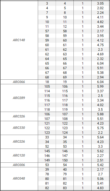


Table 3 - Hole parameters for holes listed in Table 1 (with >10g/t Au assays)


Table 4 - Hole parameters for holes listed in Table 2 (with >2.0% Cu assays)


JORC Code, 2012 Edition - Table 1
SECTION 1 SAMPLING TECHNIQUES AND DATA
(Criteria in this section apply to all succeeding sections.)
Criteria |
| Commentary |
Sampling techniques | · Nature and quality of sampling (eg cut channels, random chips, or specific specialised industry standard measurement tools appropriate to the minerals under investigation, such as down hole gamma sondes, or handheld XRF instruments, etc). These examples should not be taken as limiting the broad meaning of sampling. · Include reference to measures taken to ensure sample representivity and the appropriate calibration of any measurement tools or systems used. · Aspects of the determination of mineralisation that are Material to the Public Report. · In cases where 'industry standard' work has been done this would be relatively simple (eg 'reverse circulation drilling was used to obtain 1 m samples from which 3 kg was pulverised to produce a 30 g charge for fire assay'). In other cases more explanation may be required, such as where there is coarse gold that has inherent sampling problems. Unusual commodities or mineralisation types (eg submarine nodules) may warrant disclosure of detailed information. | · Daimond drilling was used for the five Phase One holes described in this announcement. · Drilling sampling techniques employed at the Artemis core facility include saw cut HQ (63mm) and NQ (50.6mm) drill core samples. · HQ and NQ core is currently being used to drill out the geological sequences and identify zones of mineralisation that may or may not be used in any Mineral Resource estimations, mining studies or metallurgical testwork. · Diamond core was sampled on geological intervals/contacts, with the minimum sample size of 0.25m and max 1.2m. · Core was cut in half, with one half to be sent for analysis at an accredited laboratory, while the remaining half was stored in appropriately marked core boxes and stowed in a secure core shed. · Core duplicates were quarter core, sampled from the same half sent for analysis.
|
Drilling techniques | · Drill type (eg core, reverse circulation, open-hole hammer, rotary air blast, auger, Bangka, sonic, etc) and details (eg core diameter, triple or standard tube, depth of diamond tails, face-sampling bit or other type, whether core is oriented and if so, by what method, etc). | · Diamond drilling completed by West Core Drilling. · Drilling was completed using a track mounted diamond drill · Core diameter was HQ and NQ with standard wireline drilling. · Rock types was considered to be competent, not requiring triple tube drilling. · Core was orientated using a Reflex core orientation device. |
Drill sample recovery | · Method of recording and assessing core and chip sample recoveries and results assessed. · Measures taken to maximise sample recovery and ensure representative nature of the samples. · Whether a relationship exists between sample recovery and grade and whether sample bias may have occurred due to preferential loss/gain of fine/coarse material. | · Recoveries are recorded on logging sheets and are also independently measured by drillers using drill runs. · Due to the competent nature of the rock type encountered in the projects, diamond core recovery is >90% · Statistical analysis shows that no bias of grade exists due to recoveries. |
Logging | · Whether core and chip samples have been geologically and geotechnically logged to a level of detail to support appropriate Mineral Resource estimation, mining studies and metallurgical studies. · Whether logging is qualitative or quantitative in nature. Core (or costean, channel, etc) photography. · The total length and percentage of the relevant intersections logged. | · Diamond core is placed into core trays at the drill site with all marking on the core with respect to core block depths and orientation locations completed at site. · Core trays are labelled with tray numbers and from - to depths. · Core is transferred to core logging facility where it is processed for geological, structural, geotechnical logging. · Photography of core is also completed and stored digitally within a core photo library. · The detail of logging is adequate to support a MRE and for metallurgical study. · All core is logged 100% of its length. |
Sub-sampling techniques and sample preparation | · If core, whether cut or sawn and whether quarter, half or all core taken. · If non-core, whether riffled, tube sampled, rotary split, etc and whether sampled wet or dry. · For all sample types, the nature, quality and appropriateness of the sample preparation technique. · Quality control procedures adopted for all sub-sampling stages to maximise representivity of samples. · Measures taken to ensure that the sampling is representative of the in-situ material collected, including for instance results for field duplicate/second-half sampling. · Whether sample sizes are appropriate to the grain size of the material being sampled. | · Core is marked up for sampling according to logging sheets, using the orientation line as a guide. The core cutting line is drawn 90 degrees clockwise from the orientation line, looking down the core · Core is cut in half using an Almonte automatic core saw. · One half is retained as a representative sample and replaced in the core tray; the other half is placed into a pre-labelled sample bag, recorded and sent as part of a batch to the laboratory for assaying. · The same side of the core is always retained or sent to the lab. · Duplicate samples are taken at regular intervals, using ¼ core from the assay sample. · Sample sizes are appropriate to the grain sizes of the material being sampled. |
Quality of assay data and laboratory tests | · The nature, quality and appropriateness of the assaying and laboratory procedures used and whether the technique is considered partial or total. · For geophysical tools, spectrometers, handheld XRF instruments, etc, the parameters used in determining the analysis including instrument make and model, reading times, calibrations factors applied and their derivation, etc. · Nature of quality control procedures adopted (eg standards, blanks, duplicates, external laboratory checks) and whether acceptable levels of accuracy (ie lack of bias) and precision have been established. | · A certified laboratory, ALS Chemex Perth was used for all analysis of drill samples submitted. The laboratory techniques below are for all samples submitted to ALS and are considered appropriate for the style of mineralisation defined within the Carlow Castle Project area · The sample preparation followed industry best practice. Fire assay samples were dried, coarse crushing to ~10mm, split to 300g subsample, followed by pulverisation in an LM5 or equivalent pulverising mill to a grind size of 85% passing 75 micron. · This fraction was split again down to a 50g charge for fire assay · 50-gram Fire Assay (Au-AA26) with ICP finish for Au. · All samples were dried, crushed, pulverised and split to produce a sub-sample of 50g which is digested and refluxed with hydrofluoric, nitric, hydrochloric and perchloric acid (4 acid digest). · This digest is considered a total dissolution for most minerals · Analytical analysis is performed using ICP-AES Finish (ME-ICP61) for Ag, Al, As, Ba, Be, Bi, Ca, Cd, Co, Cr, Cu, Fe, Ga, K, La, Mg, Mn, Mo, Na, Ni, P, Pb, S, Sb, Sc, Sr, Th, Ti, Tl, U, V, W, Zn. · Additional Ore Grade ICP-AES Finish (ME-OG62 for Cu reporting out of range. Pulp was split to produce a sub-sample of 50g for re-assaying. · Standards are matrix matched by using previous pulps from drilling programs and homogenised using certified laboratories. · Standards were analysed by round robins to determine grade. · Standards were routinely inserted into the sample run at 1:20. · Laboratory standards and blank samples were inserted at regular intervals and some duplicate samples were taken for QC checks. |
Verification of sampling and assaying | · The verification of significant intersections by either independent or alternative company personnel. · The use of twinned holes. · Documentation of primary data, data entry procedures, data verification, data storage (physical and electronic) protocols. · Discuss any adjustment to assay data. | · Sampling was undertaken by field assistants supervised by experienced geologists from Artemis Resources. Significant intercepts were checked by senior personnel who confirmed them as prospective for gold mineralisation. · No twin holes using RC was completed in this program. · Electronic data capture on excel spreadsheets which are then uploaded as .csv files and routinely sent to certified database management provider. · Routine QC checks performed by Artemis senior personnel and by database management consultant. · PDF laboratory certificates are stored on the server and are checked by the Exploration Manager. |
Location of Data Points | · Accuracy and quality of surveys used to locate drill holes (collar and down-hole surveys), trenches, mine workings and other locations used in Mineral Resource estimation. · Specification of the grid system used. · Quality and adequacy of topographic control. | · A Garmin GPSMap62 hand-held GPS was used to define the location of the initial drill hole collars. Standard practice is for the GPS to be left at the site of the collar for a period of 5 minutes to obtain a steady reading. Collar locations are considered to be accurate to within 5m. · A high-quality downhole north-seeking multi-shot or continuous survey gyro-camera was used to determine the dip and azimuth of the hole at 30m intervals down the hole · The topographic surface was calculated from the onsite mine survey pickups and subsequently verified by RTK GNSS collar surveys. · Zone 50 (GDA 94). · Surface collar coordinates are surveyed via RTK GNSS with 1cm accuracy by a professional surveying contractor. |
Data spacing and distribution | · Data spacing for reporting of Exploration Results. · Whether the data spacing and distribution is sufficient to establish the degree of geological and grade continuity appropriate for the Mineral Resource and Ore Reserve estimation procedure(s) and classifications applied. · Whether sample compositing has been applied. | · In certain areas, current drill hole spacing is variable and dependent on specific geological, and geochemical targets. · No sample compositing to date has been used for drilling completed by Artemis. Most results reported are the result of 1 metre downhole sample intervals, with occasional smaller interval samples. |
Orientation of data in relation to geological structure | · Whether the orientation of sampling achieves unbiased sampling of possible structures and the extent to which this is known, considering the deposit type. · If the relationship between the drilling orientation and the orientation of key mineralised structures is considered to have introduced a sampling bias, this should be assessed and reported if material. | · Drill holes were designed to be near perpendicular to the strike of known mineralisation. Due to the structural and geological complexity of the area, mineralisation of unknown orientation can be intersected. |
Sample security | · The measures taken to ensure sample security. | · The chain of custody is managed by the supervising geologist who places calico sample bags in polyweave sacks. Up to 10 calico sample bags are placed in each sack. Each sack is clearly labelled with: o Artemis Resources o Address of laboratory o Sample range · Samples were delivered by Artemis personnel to the transport company in Karratha and shrink wrapped onto pallets. · The transport company then delivers the samples directly to the laboratory. |
Audits or reviews | · The results of any audits or reviews of sampling techniques and data. | · Data is validated upon up-loading into the master database. Any validation issues identified are investigated prior to reporting of results. |
SECTION 2 REPORTING OF EXPLORATION RESULTS
(Criteria listed in the preceding section also apply to this section.)
Criteria |
| Commentary |
Mineral tenement and land tenure status | · Type, reference name/number, location and ownership including agreements or material issues with third parties such as joint ventures, partnerships, overriding royalties, native title interests, historical sites, wilderness or national park and environmental settings. · The security of the tenure held at the time of reporting along with any known impediments to obtaining a licence to operate in the area. | · Drilling by Artemis was carried out on E47/1797 - 100% owned by Artemis Resources Ltd. This tenement forms a part of a broader tenement package that comprises the West Pilbara Project. · This tenement is in good standing. |
Exploration done by other parties | · Acknowledgment and appraisal of exploration by other parties. | · The most significant work to have been completed historically in the Carlow Castle area, including the Little Fortune and Good Luck prospects, was completed by Open Pit Mining Limited between 1985 and 1987, and subsequently Legend Mining NL between 1995 and 2008. · Work completed by Open Pit consisted of geological mapping, geophysical surveying (IP), and RC drilling and sampling. · Work completed by Legend Mining Ltd consisted of geological mapping and further RC drilling. · Legend also completed an airborne ATEM survey over the project area, with follow up ground-based FLTEM surveying. Re-processing of this data was completed by Artemis and was critical in developing drill targets for the completed RC drilling. · Compilation and assessment of historic drilling and mapping data completed by both Open Pit and Legend has indicated that this data is compares well with data collected to date by Artemis. Validation and compilation of historic data is ongoing. · All exploration and analysis techniques conducted by both Open Pit and Legend are considered to have been appropriate for the style of deposit. |
Geology | · Deposit type, geological setting and style of mineralisation. | · The Carlow Castle Co-Cu-Au prospect includes a number of mineralised shear zones, located on the northern margin of the Andover Intrusive Complex. Mineralisation is exposed in numerous workings at surface along quartz-rich shear zones. Both oxide and sulphide mineralisation are evident at surface associated with these shear zones. · Sulphide mineralisation appears to consist of Chalcopyrite, chalcocite, cobaltite, pyrrhotite and pyrite |
Drill hole Information | · A summary of all information material to the understanding of the exploration results including a tabulation of the following information for all Material drill holes: · easting and northing of the drill hole collar · elevation or RL (Reduced Level - elevation above sea level in metres) of the drill hole collar · dip and azimuth of the hole · down hole length and interception depth · hole length. · If the exclusion of this information is justified on the basis that the information is not Material and this exclusion does not detract from the understanding of the report, the Competent Person should clearly explain why this is the case. | · Drill hole information is contained within this release. |
Data aggregation methods | · In reporting Exploration Results, weighting averaging techniques, maximum and/or minimum grade truncations (eg cutting of high grades) and cut-off grades are usually Material and should be stated. · Where aggregate intercepts incorporate short lengths of high grade results and longer lengths of low grade results, the procedure used for such aggregation should be stated and some typical examples of such aggregations should be shown in detail. · The assumptions used for any reporting of metal equivalent values should be clearly stated. | · All intervals reported are composed of one (1) metre down hole intervals for Reverse Circulation drilling and samples intervals are used for Diamond core are determined by geology and length weighted. · No upper cut-off grades have been used in reporting results. · No metal equivalent calculations are used in this report. |
Relationship between mineralisation widths and intercept lengths | · These relationships are particularly important in the reporting of Exploration Results. · If the geometry of the mineralisation with respect to the drill hole angle is known, its nature should be reported. · If it is not known and only the down hole lengths are reported, there should be a clear statement to this effect (eg 'down hole length, true width not known'). | · The mineralisation in the Crosscut Zone strikes generally N-S confined within NW striking bounding structures with dips to the northeast at approximately -80 -> 080 dip and dip direction. The drill orientation was 240 azim -60 dip. Drilling is believed to be generally perpendicular to strike. Given the angle of the drill holes and the interpreted dip of the host rocks and mineralisation, reported intercepts approximate true width, but are not reported.
|
Diagrams | · Appropriate maps and sections (with scales) and tabulations of intercepts should be included for any significant discovery being reported These should include, but not be limited to a plan view of drill hole collar locations and appropriate sectional views. | · Appropriate plans are shown in the text. |
Balanced reporting | · Where comprehensive reporting of all Exploration Results is not practicable, representative reporting of both low and high grades and/or widths should be practiced to avoid misleading reporting of Exploration Results. | · The significant results tabulated in the release are reported at a base grade of >0.5 g/t Au or >0.3% Cu. Internal dilution of up to 2m may be included in an intersection. |
Other substantive exploration data | · Other exploration data, if meaningful and material, should be reported including (but not limited to): geological observations; geophysical survey results; geochemical survey results; bulk samples - size and method of treatment; metallurgical test results; bulk density, groundwater, geotechnical and rock characteristics; potential deleterious or contaminating substances. | · Targeting for drilling was completed by Artemis based on compilation of historic exploration data, surface expression of targeted mineralised shear zone, ground penetrating geophysics and use of the 3D block model. |
Further work | · The nature and scale of planned further work (eg tests for lateral extensions or depth extensions or large-scale step-out drilling). · Diagrams clearly highlighting the areas of possible extensions, including the main geological interpretations and future drilling areas, provided this information is not commercially sensitive. | · The results at the Carlow Castle Co-Cu-Au project warrant further drilling. The drill program results to date are considered excellent. · Large scale geological mapping to generate further targets. |
[1] Refer to Artemis ASX announcement on 13 October 2022
[2] Refer to Artemis ASX announcement on 13 October 2022
[3] Refer to Table 1 in this announcement
[4] Refer to Table 2 in this announcement
[5] Refer to Artemis ASX announcement on 13 October 2022 and Figure 1 in this announcement
[6] Refer to Figure 1 in this announcement
[7] Refer to Artemis ASX announcements on 10 October 2024 and 28 January 2025, and Figure 3
[8] Refer to Artemis ASX announcement on 13 October 2022
[9] Refer to Tables 1-4 in this announcement
[10]Refer to Artemis ASX announcement on 10 February 2025
[11] Refer to Artemis ASX announcement on 10 October 2024
Related Shares:
Artemis Res