25th Nov 2025 07:00

THIS ANNOUNCEMENT CONTAINS INSIDE INFORMATION FOR THE PURPOSES OF ARTICLE 7 OF REGULATION 2014/596/EU WHICH IS PART OF DOMESTIC UK LAW PURSUANT TO THE MARKET ABUSE (AMENDMENT) (EU EXIT) REGULATIONS (SI 2019/310) ("UK MAR"). UPON THE PUBLICATION OF THIS ANNOUNCEMENT, THIS INSIDE INFORMATION (AS DEFINED IN UK MAR) IS NOW CONSIDERED TO BE IN THE PUBLIC DOMAIN.
NOT FOR RELEASE, PUBLICATION OR DISTRIBUTION, IN WHOLE OR IN PART, DIRECTLY OR INDIRECTLY IN OR INTO THE UNITED STATES, AUSTRALIA, CANADA, JAPAN, THE REPUBLIC OF SOUTH AFRICA OR ANY OTHER JURISDICTION WHERE TO DO SO WOULD CONSTITUTE A VIOLATION OF THE RELEVANT LAWS OF SUCH JURISDICTION.
25 November 2025
Cobra Resources plc
("Cobra" or the "Company")
Manna Hill Project Exploration Update
Geophysics Team Mobilised to Site
Approvals in place to Drill Test Blue Rose Copper Prospect Before Year End
Cobra (LSE: COBR), a South Australian critical minerals developer advancing projects across the pre-production stage, is pleased to announce it has received Program for Environment Protection and Rehabilitation ("PEPR") approval from the Government of South Australia's Department for Energy and Mining to pave the way for exploration to commence at the Manna Hill Project, an under explored porphyry province in the 'copper capital' of Australia.
As announced on 26 August 2025, Cobra has a 12-month option to acquire the Manna Hill Project and will focus initially on the Blue Rose priority prospect ("Blue Rose") where existing drilling has intersected skarn hosted copper-gold mineralisation across 1.6km of strike immediately adjacent to a geophysical anomaly interpretated as a porphyry intrusion.
Key Points:
· PEPR approved to drill up to 50 drill holes across the Blue Rose prospect
· Geophysics contractor mobilised to site to execute an Induced Polarisation ("IP") survey (12 days) at Blue Rose that aims to:
o Validate the Company's interpretation for the scale of existing mineralisation to be greatly increased by testing for an additional fold limb and syncline hinge at depth
o Refine the interpretation of the Blue Rose porphyry system
· Drilling contractor secured to execute an initial programme to commence after Christmas where ~2,800m of Reverse Circulation ("RC") drilling will target strike and depth extensions as well as the interpreted northern syncline limb, aiming to significantly increase the scale of skarn mineralisation
Rupert Verco, Managing Director of Cobra, commented:
"This is a defining period for Cobra and its shareholders. This is the first time the Blue Rose prospect has been drilled in over a decade. We have worked diligently to understand geological controls and assess upside for both scale and grade. There is no doubt that Blue Rose bears the right geological setting to deliver a major porphyry discovery.
The IP survey will seek to validate our interpretation of the structure hosting skarn mineralisation and improve the targeting of the porphyry system. Drilling will target scale upside of the existing skarn mineralisation and look to test for depth extensions of previous high-grade intersections.
This upcoming work programme is designed to demonstrate the potential of the Manna Hill asset as a basis for which the Company will look to exercise its option to acquire the Manna Hill Project."
Follow this link to watch a short video of MD Rupert Verco discussing this update on the Manna Hill Project: https://investors.cobraplc.com/link/eW3MJe
Manna Hill Exploration Strategy
The Manna Hill Project comprises Exploration Licences ("ELs") 6009, 6046 and 6646 that cover 1,855km2 and incorporate the Anabama Granite Intrusion. The Blue Rose prospect is the priority target for near term exploration during the option period.
Blue Rose - copper-gold skarn and porphyry target, shallow, scalable and open at depth
· Stratigraphic limestone unit hosting 1.6km of defined skarn mineralisation with existing intersections that include:
o [RABR822] 48m at 2.2% Cu and 0.76 g.t Au from 11m
o [RCBR025] 132m at 0.52% Cu from 8m including 48m at 1.04% Cu
o [RABR152] 41m at 1.6% Cu from 9m including 18m at 2.03% Cu
o [RABR205] 43m at 0.6% Cu from 12m
o [RCBR030] 52m at 0.77% Cu and 0.94 g/t Au from 80m
IP Survey
· A geophysical IP survey will extend across the interpreted porphyry intrusion and the length of the interpreted extent of the skarn host limestone unit
· The survey will also assist in modelling the greater porphyry system, supporting future diamond drill design aimed at testing for porphyry stockwork mineralisation at depth
· The survey will be completed in early December 2025
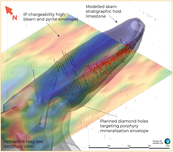
Blue Rose RC Drilling
· The Company has received PEPR approval to drill up to 50 drill holes across Blue Rose
· An initial ~2,800m programme to commence after Christmas will aim to test:
o Depth extensions and confirmation of previously reported intersection by infilling on a 50m spacing
o Extended strike towards the porphyry intrusion where previous drilling comprises shallow holes targeting near surface oxide mineralisation
o The Company's geological interpretation of a syncline hosted skarn system to deliver increased scale
· Drilling is expected to take approximately two weeks with assays expected in late January 2026
· Results will ultimately inform follow-up drilling
Figure 1: Designed IP survey lines for the survey currently underway. Interpreted porphyry intrusion and synclinal folded limestone unit (skarn host) over gravity "edge" image
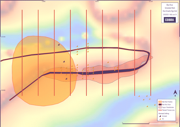
Figure 2: 3D model of the limestone unit hosting Blue Rose skarn mineralisation. Black traces represent the drill holes to be drilled in the upcoming programme. Orange traces are contingent upon results and blue traces represent future diamond drill holes based on current porphyry modelling.
Timeline for Blue Rose Exploration
· IP Survey - 20 November to 2 December 2025
· RC Stage 1 RC Drilling - December 2025 to January 2026
· Assays - January to February 2026
· RC Stage 2 RC Drilling - February 2026
· Diamond Drilling - April 2026 (contingent on above results)
Background to the Manna Hill Project
The Nakara Arc, a Cambrian age rift system, has long been recognised for its prospective porphyry systems. Previous work undertaken by the Geological Survey of South Australia, academics and explorers demonstrates:
· Deep crustal architecture defined within a Geoscience South Australia Magnetotelluric survey that defines modelled fertile, middle crust magma and structurally controlled conduits supportive of porphyry intrusions.1
· Geochemical and geochronological studies performed by Hong et al, 2023 demonstrate that porphyritic stocks at Anabama and Netley Hill have formed from favourable lithospheric scale structures and simultaneously with known porphyry systems within the Macquarie Arc such as Cadia and North Parkes.1
The project comprises numerous prospects with varying styles of mineralisation including skarn, porphyry, carlin, orogenic and sediment hosted mineralisation across 1,855 km2 of tenure that includes the historic Wadnaminga and Talkaboolka goldfields.
Exploration over the project has been limited over the last two decades owing to land access. Land access has been achieved with a Native Title Mining Agreement with the Wilyakali Traditional Owners paving the way for exploration across this highly fertile geological province.
Located 150km southwest of Broken Hill, the township and mining asset which was the starting point for the world's largest miner, BHP, the region is well serviced by road and rail.
References
1. Wei Hong, Adrian Fabris, Tom Wise, Allan S Collins, Sarah Gilbert, David Selby, Stacey Curtis and Anthony Reid, 2023 Economic Geology. "Metallogenic Setting and Temporal Evolution of Porphyry Cu-Mo Mineralisation and Alteration in the Delamerian Orogen, South Australia: Insights From Zircon, U-Pb, Molybdenite Re-Os, and In Situ White Mica Rb-Sr Geochronology."
2. Collar coordinates for RCBR030 has not been verified within the database but was announced on 8 July 2002: asx.com.au/asx/v2/statistics/displayAnnouncement.do?display=text&issuerId=558&announcementId=493738&documentDate=2002-07-08&documentNumber=219186
Enquiries:
Cobra Resources plc Rupert Verco (Australia) Dan Maling (UK)
| via Vigo Consulting +44 (0)20 7390 0234
|
SI Capital Limited (Joint Broker) Nick Emerson Sam Lomanto
| +44 (0)1483 413 500
|
Global Investment Strategy (Joint Broker) James Sheehan | +44 (0)20 7048 9437 |
Vigo Consulting (Financial Public Relations) Ben Simons Fiona Hetherington | +44 (0)20 7390 0234 |
The person who arranged for the release of this announcement was Rupert Verco, Managing Director of the Company.
About Cobra
Cobra Resources is a South Australian critical minerals developer, advancing assets at all stages of the pre-production pathway.
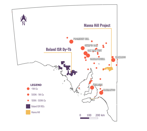
In 2023, Cobra identified the Boland ionic rare earth discovery at its Wudinna Project in the Gawler Craton - Australia's only rare earth project suitable for in situ recovery (ISR) mining. ISR is a low-cost, low-disturbance extraction method that eliminates the need for excavation, positioning Boland to achieve bottom-quartile recovery costs.
In 2025, Cobra further expanded its portfolio by optioning the Manna Hill Copper Project in the Nackara Arc, South Australia. The project contains multiple underexplored prospects with strong potential to deliver large-scale copper discoveries.
In 2025, Cobra sold its Wudinna Gold Assets to Barton Gold (ASX: BDG) for up to A$15 million in cash and shares.
Regional map showing Cobra's tenements in South Australia
Boland Project
Cobra's unique and highly scalable Boland discovery is a strategically advantageous ionic rare earth discovery where high grades of valuable heavy and magnet rare earths occur concentrated in a permeable horizon confined by impermeable clays. Bench scale ISR testing has confirmed that mineralisation is amenable to ISR mining. ISR has been used successfully for decades within geologically similar systems to recover uranium within South Australia. Results of this metallurgical test work support that, with minor optimisation, ISR techniques should enable non-invasive and low-cost production of critical REEs from Cobra's Boland discovery.
Manna Hill Project
Cobra has entered a binding Option Deed to acquire the Manna Hill Project ("the Manna Hill Option"), a forgotten porphyry province within the copper capital of Australia. The project has the potential to deliver the next tier 1 discovery. Historical intersections include 48m @ 2.2% Cu & 0.76 g/t Au and 132m at 0.5% Cu, and underpin the potential to deliver the next multi-million tonne copper resource.
Follow us on social media:
LinkedIn: https://www.linkedin.com/company/cobraresourcesplc
X: https://twitter.com/Cobra_Resources
Engage with us by asking questions, watching video summaries and seeing what other shareholders have to say. Navigate to our Interactive Investor hub here: https://investors.cobraplc.com/
Subscribe to our news alert service: https://investors.cobraplc.com/auth/signup
Competent Persons Statement
Information and data presented within this announcement has been compiled by Mr Robert Blythman, a Member of the Australian Institute of Geoscientists ("MAIG"). Mr Blythman is a Consultant to Cobra Resources Plc and has sufficient experience, which is relevant to the style of mineralisation, deposit type and to the activity which he is undertaking to qualify as a Competent Person defined by the 2012 Edition of the Australasian Code for Reporting Exploration Results, Mineral Resources and Ore Reserves (the "JORC" Code). This includes 12 years of Mining, Resource Estimation and Exploration relevant to the style of mineralisation.
Information in this announcement has been assessed by Mr Rupert Verco, a Fellow of the Australasian Institute of Mining and Metallurgy. Mr Verco is an employee of Cobra and has more than 17 years' industry experience which is relevant to the style of mineralisation, deposit type, and activity which he is undertaking to qualify as a Competent Person as defined in the 2012 Edition of the Australasian Code for Reporting Exploration Results, Mineral Resources and Ore Reserves of JORC. This includes 13 years of Mining, Resource Estimation and Exploration.
Appendix 1: JORC Code, 2012 Edition - Table 3
Criteria | JORC Code explanation | Commentary |
Sampling techniques | · Nature and quality of sampling (eg cut channels, random chips, or specific specialised industry standard measurement tools appropriate to the minerals under investigation, such as down hole gamma sondes, or handheld XRF instruments, etc). These examples should not be taken as limiting the broad meaning of sampling. · Include reference to measures taken to ensure sample representivity and the appropriate calibration of any measurement tools or systems used. · Aspects of the determination of mineralisation that are Material to the Public Report. · In cases where 'industry standard' work has been done this would be relatively simple (eg 'reverse circulation drilling was used to obtain 1 m samples from which 3 kg was pulverised to produce a 30 g charge for fire assay'). In other cases more explanation may be required, such as where there is coarse gold that has inherent sampling problems. Unusual commodities or mineralisation types (eg submarine nodules) may warrant disclosure of detailed information. | · Drill results are historic, reported from previous explorers across multiple company databases. · GS Series holes have uncertain sampling methods but 2024 HGRC series holes across reflected the grade tenor and distribution · Blue Rose drill results were undertaken over multiple generations with validation required. Sample lengths were between 1m and 4m. sample types are listed as composites and splits in historically reported data for the reported results. · NETRP series holes were completed in the late 1960s as percussion holes. Results are considered reflective of typical grades and scale but are historic in nature. · NETDD holes were diamond holes that were half core samples to 1m length. · Select review of sampling data provided indicates the retained data is of good quality. |
Drilling techniques | · Drill type (eg core, reverse circulation, open-hole hammer, rotary air blast, auger, Bangka, sonic, etc) and details (eg core diameter, triple or standard tube, depth of diamond tails, face-sampling bit or other type, whether core is oriented and if so, by what method, etc). | RAB, AC, RC, percussion and diamond drilling methods have all been used with AC and RC being the dominant drill methods on a per m basis. Further assessment of the drilling methods will be undertaken during data validation and migration. Select review of drilling data provides indicates the retained data is of good quality. |
Drill sample recovery | · Method of recording and assessing core and chip sample recoveries and results assessed. · Measures taken to maximise sample recovery and ensure representative nature of the samples. · Whether a relationship exists between sample recovery and grade and whether sample bias may have occurred due to preferential loss/gain of fine/coarse material. | · Sample recovery data is limited. · Blue Rose prospect, sample codes L.N.R. are less than 0.1% of assessed data. · Netley Hill, Diamond drilling appears to have excellent recoveries based on core photos with NTRP sewries holes not expected to have recovery data · At Golden Sophia, 2024 HGRC drilling had consistent good recoveries as reported in sampling with historic GS drilling expected to be comparable. |
Logging | · Whether core and chip samples have been geologically and geotechnically logged to a level of detail to support appropriate Mineral Resource estimation, mining studies and metallurgical studies. · Whether logging is qualitative or quantitative in nature. Core (or costean, channel, etc) photography. · The total length and percentage of the relevant intersections logged. | · A review of historic logging has determined the quality of logging to be good. · Translation of logging codes to a uniform code library across the project will be undertaken to ensure consistency of historic logging for future interpretation. |
Sub-sampling techniques and sample preparation | · If core, whether cut or sawn and whether quarter, half or all core taken. · If non-core, whether riffled, tube sampled, rotary split, etc and whether sampled wet or dry. · For all sample types, the nature, quality and appropriateness of the sample preparation technique. · Quality control procedures adopted for all sub-sampling stages to maximise representivity of samples. · Measures taken to ensure that the sampling is representative of the in situ material collected, including for instance results for field duplicate/second-half sampling. · Whether sample sizes are appropriate to the grain size of the material being sampled. | · Sample data is historic and all processes and proceduresare unknown. There is records of sample splits being sent for lab analysis after initial composite sampling had taken place. Core samples are reported to be half core sent to the lab · Further validation of the data will be undertaken during the data validation and migration. · Sampling technique is not expected to have applied a bias to results.
|
Quality of assay data and laboratory tests | · The nature, quality and appropriateness of the assaying and laboratory procedures used and whether the technique is considered partial or total. · For geophysical tools, spectrometers, handheld XRF instruments, etc, the parameters used in determining the analysis including instrument make and model, reading times, calibrations factors applied and their derivation, etc. · Nature of quality control procedures adopted (eg standards, blanks, duplicates, external laboratory checks) and whether acceptable levels of accuracy (ie lack of bias) and precision have been established. | · Laboratory analysis is from cetified labs and most certificates are on file therefore analysis is expected to be of adequate quality · NETRP series holes have limited associated lab data but are considered to be refective of in situ grades and acceptable to report in a historic context. · Historic lab certificates indicate analytical methods have been primarily 4 acid digest for ore grade copper and a mixture of aqua regia and fire assay for gold. Other elements assayed have been a mixture of aqua regia digest and 4 acid digest. These techniques are acceptable in this geological setting with 4 acid digest preferred. · Standards, blanks and duplicates have been included in some historic lab jsubmissions. |
Verification of sampling and assaying | · The verification of significant intersections by either independent or alternative company personnel. · The use of twinned holes. · Documentation of primary data, data entry procedures, data verification, data storage (physical and electronic) protocols. · Discuss any adjustment to assay data. | · Historic data has been compiled from multiple open file and historic company sources · For Blue Rose, drill results are geologically consistent across multiple historic drill programs managed by different companies and different drill techniques · For Netley Hill, NETRP holes are considered historic and indicative, NETDD holes are considered to be of high quality. · Data validation will be completed on compiled data during a database migration to ensure appropriate confidence in results is applied. · Historic lab certificate results will be used as a primary source for a large portion of assay data · Significant intersections have been prepared by Mr Robert Blythman and reviewed by Mr Rupert Verco |
Location of data points | · Accuracy and quality of surveys used to locate drill holes (collar and down-hole surveys), trenches, mine workings and other locations used in Mineral Resource estimation. · Specification of the grid system used. · Quality and adequacy of topographic control. | · Drillhole collars have been picked up by GPS post 2003 based on historic reporting · Prior to 2003, drillholes were reported as NOM · Field validation of historic collars shows historic holes were within 10-20m consistently and generally within 5m · NETRP series holes have not been field validated and are considered spatially indicative. Limited historical surface evidence indicates the program occurring in the correct area. |
Data spacing and distribution | · Data spacing for reporting of Exploration Results. · Whether the data spacing and distribution is sufficient to establish the degree of geological and grade continuity appropriate for the Mineral Resource and Ore Reserve estimation procedure(s) and classifications applied. · Whether sample compositing has been applied. | · All reported results are being reported as historic in nature with no resource classification applied at this stage. · Preliminary review of the historic data available has the potential to be used in a resource estimation, particularly at Blue Rose once historic data validation has been completed. · Significant intersections have been calculated as downhole length weighted averages. |
Orientation of data in relation to geological structure | · Whether the orientation of sampling achieves unbiased sampling of possible structures and the extent to which this is known, considering the deposit type. · If the relationship between the drilling orientation and the orientation of key mineralised structures is considered to have introduced a sampling bias, this should be assessed and reported if material. | · Intersections are expected to be oblique to mineralization. · Drill orientation is not expected to have introduced bias to grades reported |
Sample security | · The measures taken to ensure sample security. | · Samples are considered historic, no tampering with samples is expected. · HGRC series drillholes were zip tied in polyweave bags and sent directly to the lab by Hamelin Gully contractors from the drill site in zip tied Bulka bags. |
Audits or reviews | · The results of any audits or reviews of sampling techniques and data. | · A full review of historic data is underway to ascertain historic data confidence. Preliminary findings have shown drilling and assay data is of a good quality and appropriate for further use. |
Appendix 2: Section 2 reporting of exploration results
Criteria | JORC Code explanation | Commentary |
Mineral tenement and land tenure status | · Type, reference name/number, location and ownership including agreements or material issues with third parties such as joint ventures, partnerships, overriding royalties, native title interests, historical sites, wilderness or national park and environmental settings. · The security of the tenure held at the time of reporting along with any known impediments to obtaining a licence to operate in the area. | · EL's 6009, 6046 and 6646 are 100% Owned by Hamelin Gully Pty Ltd and are in good standing · A Native Title Mining Access Agreement is in Place between Hamelin Gully and the Wilyakali Traditional Owners. A 1% over riding royalty is in place between Hamelin Gully and David Clarke, · |
Exploration done by other parties | · Acknowledgment and appraisal of exploration by other parties. | · A multitude of historic explorers have undertaken exploration over the area. · PacMag, Giralia, Lynas, Dominion, Panda and Hamelin Gully have completed a number of geophysical, surface and drillhole exploration programs across the tenement package. The tenement package has also had government exploration undertaken over the Netley Hill, Anabama Hill and Blue Rose Project areas. Exploration has primarily been focused on porphyry- skarn copper and gold mineralization. Iron ore exploration has been undertaken on the periphery of the exploration package |
Geology | · Deposit type, geological setting and style of mineralisation. | · Mineralisation is associated with the Anabama Granite and adjacent Adelaidean metasediments within the Nackara Arc of the Delamerian Orogen. · Deposit styles include: · Porphyry Cu-Mo systems with greisen overprint hosted within the granite. · Skarn and replacement (manto-style) Cu-Au mineralisation developed in carbonate metasediments proximal to intrusive contacts. · Structurally controlled quartz-reef/orogenic gold styles within folded Adelaidean sequences, analogous to the Manna Hill goldfield. · Geological setting is characterised by early Palaeozoic granite intrusion into Adelaidean platform sediments, with contact-related alteration and deformation associated with the Delamerian Orogeny. · Styles of mineralisation include disseminated and stockwork sulphides (chalcopyrite, pyrite, molybdenite), carbonate replacement/recrystallisation with sulphides, and quartz-sulphide reef systems in shear/fold settings
|
Drillhole Information | · A summary of all information material to the understanding of the exploration results including a tabulation of the following information for all Material drill holes: o easting and northing of the drill hole collar o elevation or RL (Reduced Level - elevation above sea level in metres) of the drill hole collar o dip and azimuth of the hole o down hole length and interception depth o hole length. · If the exclusion of this information is justified on the basis that the information is not Material and this exclusion does not detract from the understanding of the report, the Competent Person should clearly explain why this is the case. | · see appendix 3 · A full review and validation of all historic data is currently being undertaken prior to the full report of all historic data. |
Data aggregation methods | · In reporting Exploration Results, weighting averaging techniques, maximum and/or minimum grade truncations (eg cutting of high grades) and cut-off grades are usually Material and should be stated. · Where aggregate intercepts incorporate short lengths of high grade results and longer lengths of low grade results, the procedure used for such aggregation should be stated and some typical examples of such aggregations should be shown in detail. · The assumptions used for any reporting of metal equivalent values should be clearly stated. | · Significant intersections are calculated as length weighted averages. · Only metal equivalent values were applied within the cross section (Figure 4) to simplify overlapping intersections. The formula applied does not include metal recoveries and is therefore not a true representation of mineral economics. Applied formula is: · CuEq% = Cu% + ((Au (g/t) x (US$3,000/31.10348) / (US$9,000/100)) + ((Mo % x (US$40,000/100) / ($9,000/100)) |
Relationship between mineralisation widths and intercept lengths | · These relationships are particularly important in the reporting of Exploration Results. · If the geometry of the mineralisation with respect to the drill hole angle is known, its nature should be reported. · If it is not known and only the down hole lengths are reported, there should be a clear statement to this effect (eg 'down hole length, true width not known'). | · Intercept lengths are oblique to mineralization with downhole lengths reported only · Further review of historic data is required before determining true drillhole width |
Diagrams | · Appropriate maps and sections (with scales) and tabulations of intercepts should be included for any significant discovery being reported These should include, but not be limited to a plan view of drill hole collar locations and appropriate sectional views. | · Relevant diagrams have been included in the announcement. · Exploration results are not being reported for existing mineral resources. · Additional collar locations in diagrams reflect spatial location of historic data under review. |
Balanced reporting | · Where comprehensive reporting of all Exploration Results is not practicable, representative reporting of both low and high grades and/or widths should be practiced to avoid misleading reporting of Exploration Results. | · Significant intersections have been reported to highlight exploration potential of the project. Upon completion of historic data review, further reporting of existing results will be reported |
Other substantive exploration data | · Other exploration data, if meaningful and material, should be reported including (but not limited to): geological observations; geophysical survey results; geochemical survey results; bulk samples - size and method of treatment; metallurgical test results; bulk density, groundwater, geotechnical and rock characteristics; potential deleterious or contaminating substances. | · Completion of historic exploration data is underway. All meaningful results will be released once the historic data review has been completed. |
Further work | · The nature and scale of planned further work (eg tests for lateral extensions or depth extensions or large-scale step-out drilling). · Diagrams clearly highlighting the areas of possible extensions, including the main geological interpretations and future drilling areas, provided this information is not commercially sensitive. | · Finalisation of historic data review. · Planning for RC and diamond drilling at Blue Rose and Netley Hill Prospects underway; Drilling will aim to confirm geological interpretations and validate pervious intersections |
Appendix 3: Collar locations of reported intersections
BHID | Easting | Northing | Elevation | Dip | Azimuth | Length |
BRDD003 | 429020 | 6388425 | 240 | -60.8 | 172 | 227.8 |
BRRB11 | 428922 | 6388377 | 239 | -90 | 0 | 48 |
BRRC18 | 429052 | 6388338 | 238 | -90 | 0 | 100 |
GS2 | 437060 | 6398114 | 287 | -60 | 340 | 40 |
GS27 | 437151 | 6398102 | 285 | -60 | 162 | 40 |
GS29 | 437160 | 6398064 | 285 | -60 | 162 | 40 |
GS3 | 437067 | 6398084 | 287 | -60 | 344 | 70 |
GS4 | 437075 | 6398046 | 286 | -60 | 343 | 40 |
HGRC0003 | 437090 | 6398076 | 286 | -60 | 345 | 124 |
NTDD001 | 411017 | 6370179 | 280 | -90 | 0 | 350 |
NETRP14 | 410433 | 6370263 | 280 | -90 | 0 | 76 |
NETRP03 | 411053 | 6370125 | 280 | -90 | 0 | 79 |
RABR186 | 429372 | 6388377 | 235 | -90 | 0 | 40 |
RABR150 | 429272 | 6388357 | 237 | -90 | 0 | 47 |
RABR151 | 429322 | 6388382 | 236 | -90 | 0 | 60 |
RABR152 | 429372 | 6388357 | 236 | -90 | 0 | 50 |
RABR155 | 429372 | 6388347 | 236 | -60 | 172 | 23.5 |
RABR187 | 429372 | 6388297 | 237 | -90 | 0 | 40 |
RABR191 | 429272 | 6388337 | 237 | -90 | 0 | 37 |
RABR198 | 428822 | 6388403 | 239 | -90 | 0 | 54 |
RABR203 | 428922 | 6388327 | 238 | -90 | 0 | 51 |
RABR205 | 429022 | 6388352 | 239 | -90 | 0 | 55 |
RABR209 | 429172 | 6388327 | 237 | -90 | 0 | 59 |
RABR211 | 429321 | 6388278 | 237 | -90 | 0 | 19 |
RABR212 | 429322 | 6388252 | 237 | -90 | 0 | 63 |
RABR213 | 429322 | 6388227 | 236 | -90 | 0 | 42 |
RABR214 | 429472 | 6388402 | 232 | -90 | 0 | 46.5 |
RABR523 | 428872 | 6388327 | 238 | -90 | 0 | 72 |
RABR609 | 428722 | 6388302 | 240 | -90 | 0 | 54 |
RABR822 | 429348 | 6388361 | 236 | -90 | 0 | 59 |
RBBR18 | 429322 | 6388177 | 235 | -90 | 0 | 12 |
RCBR019 | 429322 | 6388337 | 237 | -90 | 0 | 122 |
RCBR021 | 429127 | 6388342 | 238 | -90 | 0 | 152 |
RCBR022 | 429122 | 6388377 | 238 | -60 | 172 | 122 |
RCBR023 | 429122 | 6388327 | 238 | -60 | 172 | 116 |
RCBR025 | 429322 | 6388377 | 236 | -60 | 172 | 140 |
RCBR026 | 429322 | 6388327 | 237 | -60 | 172 | 116 |
RCBR027 | 429422 | 6388352 | 234 | -60 | 172 | 110 |
RCBR029D | 429322 | 6388427 | 236 | -60 | 172 | 219 |
RCBR030 | 429122 | 6388427 | 238 | -60 | 172 | 188 |
Related Shares:
Cobra Resources