22nd Jan 2026 07:41
 Greatland Resources Limited
W: https://greatland.com.au
 : x.com/greatlandgold
NEWS RELEASE | 22 January 2026
Resource Development & Exploration Activities ReportDecember Quarter 2025
THIS ANNOUNCEMENT CONTAINS INSIDE INFORMATION AS STIPULATED UNDER THE UK MARKET ABUSE REGULATIONS. ON PUBLICATION OF THIS ANNOUNCEMENT VIA A REGULATORY INFORMATION SERVICE, THIS INFORMATION IS CONSIDERED TO BE IN THE PUBLIC DOMAIN.
Record FY26 drilling and exploration program continues to deliver
Promising results from the second quarter of Telfer's record drilling program, including highest grade West Dome Underground drilling results to date
Highlights
Telfer Resource Development Drilling
§ 54,204 metres (resource growth and conversion drilling) completed from 756 holes during the December quarter (September quarter: 53,543 metres; FY26 H1: 106,766 metres).
§ Greatland remains well placed to deliver on its record 240,000m Telfer FY26 drilling program, with increased drill capacity now on site to accelerate the program in the March 2026 quarter.
West Dome Underground
§ 11 holes for 6,284m drilled during the quarter at the West Dome Underground (WDU) project, with further exceptional drilling results continuing to grow the scale of the opportunity.
§ In addition to the results reported on 27 November 2025 (refer to announcement "West Dome Underground Project Update"), assays from a further 10 holes were received during the quarter, with the following significant results:
- 55.3m @ 7.4 g/t Au & 0.43 % Cu (411 gram-metres Au (gm)1) from 427m (WUC4550104)
- 27.0m @ 9.3 g/t Au & 0.15 % Cu (251gm) from 495m (WUC4550104)
- 50.2m @ 2.8 g/t Au & 0.36 % Cu (141gm) from 263m (WUC4550105)
- 27.1m @ 3.2 g/t Au & 0.95 % Cu (87gm) from 323m (WUC4550068)
- 15.8m @ 5.0 g/t Au & 0.23 % Cu (79gm) from 332m (WUC4550087)
§ Maiden Mineral Resource Estimate remains targeted in the March 2026 quarter.
Note (1): Formula: gm = interval width multiplied by Au grade
West Dome Open Pit
§ 20,769m of resource growth drilling completed during the quarter; with the completion of the targeted Stage 7 extension drilling early in the quarter, drill capacity has now shifted to focus on the multi-year Stage 2 extension opportunity.
§ 19,368m of resource conversion drilling completed during the quarter, providing increased geological confidence for the material within both Stage 7 and Stage 2 extensions to underpin the remainder of FY26 mine plan.
Main Dome Underground
§ 7,756m drilled across 86 holes, targeting resource conversion & growth drilling across several near-mine targets during the quarter.
§ Growth drilling has confirmed and extended mineralisation at both ESC South and Kylo.
Regional Exploration
§ South-East Hub satellite extension drilling at the Big Tree deposit confirmed mineralisation down dip of historic drilling and along strike of the deposit.
§ Paterson South Farm-In drill testing was completed at the Teague prospect, approximately 35km east-southeast of Telfer. Highly encouraging gold and pathfinder element mineralisation was intersected in hole TRS007RCD:
- 8m @ 1.30g/t Au from 241m (including 3m @ 3.11 g/t Au from 241m)
- 15m @ 0.40g/t Au from 150m (including 4m @ 0.98g/t Au from 161m)
§ Assay results were received for the remaining holes in the Thomsons deposit extension drill program, identifying down dip mineralisation and east west orientated high-grade veins aligned subparallel to previous drilling, with a peak of 0.62m @ 35.06g/t Au & 0.04% Cu from 478m THO25RCD014.
§ Growth drilling continued at the Camp Dome deposit, testing for extensions to mineralisation below the oxide deposit.
§ Ernest Giles first pass testing of Induced Polarity (IP) anomalies was completed with diamond drillhole tails. Peak gold mineralisation was recorded in drillhole EGD009, with mineralisation open along strike and up and down dip:
- 9m @ 0.72g/t Au from 349m (including 3m @ 1.30 g/t Au from 349m and 1m @ 2.43 g/t Au from 354m)
Greatland Managing Director, Shaun Day, commented:
"Our record 240,000m annual drilling program at Telfer has continued to deliver very promising results in the December quarter, which strongly support the potential for multi-year Telfer life of mine extension from both open pit and underground opportunities.
"The high-grade West Dome Underground project is particularly exciting, returning the highest gram-metre intercept to date of 55.3m at 7.4 g/t gold and 0.43 % copper (411 gram-metres gold). Encouragingly, this result is the southern most assay returned to date, and the mineral system is increasing in size towards the south which remains open. Three diamond drill rigs are now operating at the project and a maiden Mineral Resource estimate is targeted in the March 2026 quarter.
"Resource growth and conversion drilling in the West Dome Open Pit and Main Dome Underground continue to enhance our geological confidence in near term mining areas and longer-term extension opportunities. In total, over 100,000 metres of new resource growth drilling will inform our next Telfer Mineral Resource update in the March 2026 quarter.
"The quarter's regional exploration results are encouraging, both in the Paterson and at our Ernest Giles project, an Archean greenstone in the Yilgarn region."
Overview
Greatland Resources Limited (Greatland) is pleased to provide this update on resource development and exploration activities.
Telfer Resource Development
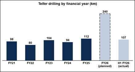
Greatland remains on track to complete the largest annual drilling program in Telfer's operating history, with ~240,000 metres total drilling planned in FY26, comprising ~150,000m of resource growth drilling and ~90,000m of resource conversion drilling.
First half (June to December 2025) drilling of 106,766m has now been completed, in line with the planned delivery schedule.
Figure 1: Telfer historic and planned FY26 drilling
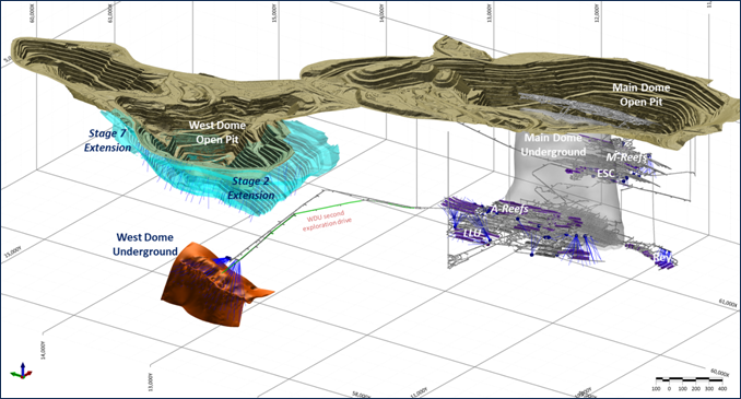
The objective of the planned drilling is expansion and conversion of Telfer Mineral Resources to support targeted further multi-year mine life extensions. Three key extension opportunities are presently targeted, the West Dome Open Pit (WDO), Main Dome Underground (MDU) and West Dome Underground (WDU).
Figure 2: Telfer planned Resource Development drilling by area
A total of 54,204m was drilled during the quarter, comprising:
§ Conversion: 565 holes for 19,183m; and
§ Growth: 190 holes for 34,863m.
A fifth underground diamond drill (DD) rig was mobilised during the quarter, and the decision has been made to add a sixth underground DD rig based on the continued success in the WDU drilling program. The sixth underground rig is expected to arrive in February 2026 to enable testing of the expanse of the WDU mineralisation (extension drilling).
Three reverse circulation (RC) rigs continued drilling throughout the quarter with a relatively even split between growth and conversion drilling. Conversion drilling in FY26 H1 has now provided increased geological confidence across all active mining areas, allowing increased growth drilling focus for the remainder of FY26.
West Dome Open Pit (WDO)
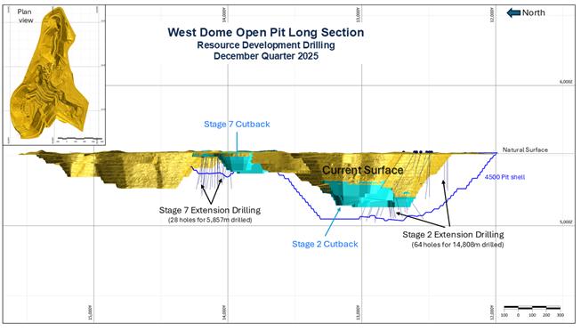
Drilling for the December quarter remained focused on two priority cutback opportunities:
§ Stage 7 Extension: Extension of the existing Stage 7 cutback towards the north (refer Figure 3), which is expected to provide Telfer's baseload ore feed for FY27 and FY28.
§ Stage 2 Extension: Extension of the current Stage 2 towards the south, east and west. The area being targeted with drilling is substantial and has the potential to support multi-year extension of the Telfer open pit mine life beyond FY28.
Stage 7 Extension drilling was completed during the quarter, with drill capacity shifting to predominately concentrate on the southern Stage 2 Extension which will remain a focus for much of the March 2026 quarter.
Figure 3: West Dome Open Pit - December 2025 Quarter (Q2 FY2026) Drilling
Drilling in the West Dome continues to increase our confidence in the geological model that underpins the Mineral Resource, with a combination of reef hosted and wide stockwork domains intercept to date.
The following significant results were returned during the quarter, with the full list of results in Table 1.
Stage 7 Extension
A total of 28 resource growth holes for 5,857 metres was completed in the quarter, with the following significant results:
§ 35m @ 4.8 g/t Au & 0.30 % Cu (167 gm) from 273m (WR28748)
§ 45m @ 0.9 g/t Au & 0.07 % Cu (41 gm) from 147m (WR39551)
§ 41m @ 1.0 g/t Au & 0.02 % Cu (41 gm) from 121m (WR39552)
§ 42m @ 0.8 g/t Au & 0.21 % Cu (35 gm) from 159m (WR39219)
§ 36m @ 1.0 g/t Au & 0.24 % Cu (36 gm) from 166m (WR40079)
§ 20m @ 1.6 g/t Au & 0.07 % Cu (24 gm) from 58m (WR39554)
§ 42m @ 0.6 g/t Au & 0.02 % Cu (25 gm) from 168m (WR40737)
All results have been received and the Mineral Resource update is in progress.
Stage 2 Extension
A total of 63 resource growth holes for 14,804 metres was completed during the quarter, with the following significant results:
§ 22m @ 2.9 g/t Au & 0.33 % Cu (65 gm) from 168m (WR24227)
§ 49m @ 0.9 g/t Au & 0.09 % Cu (47 gm) from 10m (WR27230)
§ 38m @ 1.1 g/t Au & 0.27 % Cu (42 gm) from 146m (WR24226)
§ 11m @ 3.2 g/t Au & 0.10 % Cu (36 gm) from 403m (WR25707)
§ 38m @ 0.6 g/t Au & 0.07 % Cu (24 gm) from 28m (WR27595)
§ 21m @ 0.9 g/t Au & 0.06 % Cu (20 gm) from 58m (WR33156)
With the completion of most of the growth drilling in the active mining areas during the December quarter, drilling will now shift to testing from both the eastern and western sides of the Stage 2 southern extension.
Main Dome Underground (MDU)
The first half of FY26 drilling campaign in the MDU has been focused on near term extension opportunities, and has successfully confirmed multiple near mine extensions such as A Reef, Tarkin (LLU), Rey extensions and the Eastern Stockwork Corridor (ESC) that have been drilled to a mine ready status and delivered to the operations team.
The focus of the second half of FY26 drilling is longer term growth opportunities, such as the ESC extensions, VSC, Kylo and A Reef North, which have the potential to provide significant mine life extension and are all adjacent to the existing underground infrastructure.
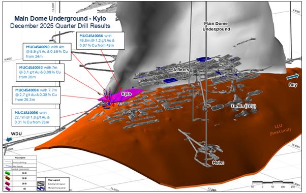
December quarter drilling in the MDU comprised 86 holes for 7,606 metres focused on the A Reef & ESC, with resource conversion and resource growth drilling at the Kylo target completed during the quarter.
Following the September quarter's impressive results at Kylo, additional results were received in the December quarter (Figure 4) confirming the presence of significant mineralisation. Drilling has delineated both narrow high grade reef style and broader stockwork style mineralisation, with the technical review underway to direct future drilling and extraction options.
The following significant results were received from Kylo drilling during the quarter:
§ 17m @ 3.1 g/t Au & 0.09 % Cu (60 gm) from 28m (MUC4540093)
§ 4.0m @ 8.9 g/t Au & 0.59 % Cu (36 gm) from 34m (MUC4540090)
§ 7.7m @ 2.7 g/t Au & 0.38 % Cu (21 gm) from 26.3m (MUC4540094)
§ 22.1m @ 1.8 g/t Au & 0.31 % Cu (39 gm) from 28m (MUC4540096)
§ 49.8m @ 1.2 g/t Au & 0.07 % Cu (60 gm) from 49m (MUC4540086)
Figure 4: Main Dome Underground -Kylo December 2025 Quarter Drilling
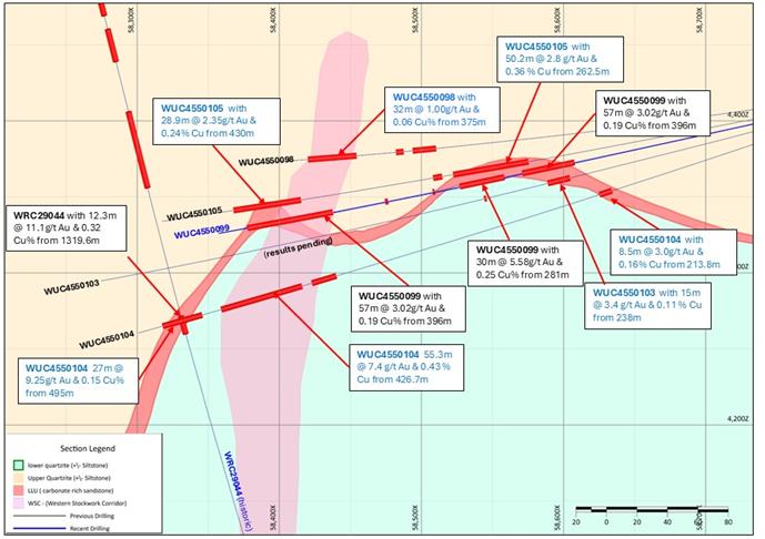
West Dome Underground (WDU)
Greatland's announcement on 27 November 2025 "West Dome Underground Project Update" included assay results from a further 9 new holes that were received prior to that announcement.
Increasing drill density has improved understanding of the WDU, with three mineralised domains now confirmed: a broad sub-vertical Western Stockwork Corridor (WSC), flanked by the extensive Western Limb and Eastern Limb high grade shoots hosted within the Lower Limey Unit (LLU), an important geological horizon for gold-copper mineralisation at Telfer.
Western Stockwork Corridor (WSC)
The WSC mineralisation is located within the hinge of the WDU fold (Figure 5) and consists of a broad zone of concordant and discordant stockwork/sheeted and breccia veins, containing chalcopyrite, pyrite, white & pink dolomite, quartz and galena. There is also a notable overprinting of albite alteration.
The potential of this domain was first identified during the maiden underground drilling campaign, which although focused on the high-grade Western Limb also intercepted several broad zones of stockwork mineralisation within the hinge of the fold.
Recent drilling to the south (Figure 5) has return multiple intercepts of broad higher-grade mineralisation within the WSC during the quarter, with the following significant results returned during the quarter:
§ 55.3m @ 7.4 g/t Au & 0.43 % Cu (411 gm) from 426.7m (WUC4550104)
§ 29m @ 2.0 g/t Au & 0.01 % Cu from (58 gm) 405m (WUC4550102)
§ 56.6m @ 2.2 g/t Au & 1.26% Cu (127gm) from 337m (WUC4550083) - previously announced2
§ 82.2 @ 1.9 g/t Au & 0.31% Cu (156gm) from 360.7m (WUC4550092) - previously announced2
§ 66.5m @ 1.18 g/t Au & 0.16% Cu (78gm) from 334m (WUC4550085) - previously announced2
§ 24.0m @ 1.18 g/t Au & 0.10% Cu (28gm) from 309m (WUC4550081) - previously announced2
The drilling to date confirms continuous WSC mineralisation over 700m of strike, averaging approximately 40m wide (true width) x 150m dip extent (height), and remains open along strike, and up and down dip. These recent results indicate higher grade and increased width to the south of the Phase 1 drilling.
The WSC is considered comparable to the Vertical Stockwork Corridor or 'VSC' domain that was one of the dominant domains targeted by the Sub-Level Cave (SLC) at the Telfer Main Dome Underground from 2008 to 2019 (mining approximately 5Mtpa on average) and is a key extension opportunity currently under assessment.
Western Limb
The Western Limb of LLU mineralisation has returned some of the highest grade WDU results to date and this continues to be the case. Mineralisation has been confirmed over 700m in strike, averaging 10m wide and over 100m down dip to date, and remains open to the north and south.
The following significant results were returned during the quarter:
§ 27.0m @ 9.3 g/t Au & 0.15 % Cu (250 gm) from 495m (WUC4550104)
§ 27.1m @ 3.2 g/t Au & 0.95 % Cu (88 gm) from 323m (WUC4550068)
§ 15.8m @ 5.0 g/t Au & 0.23 % Cu (79 gm) from 332m (WUC4550087)
§ 28.9m @ 2.4g/t Au & 0.24% Cu (68 gm) from 430m (WUC4550105)
§ 30.1m @ 1.6 g/t Au & 0.48 % Cu (49 gm) from 368m (WUC4550084)
§ 28m @ 1.8 g/t Au & 0.34% Cu (52gm) from 366m (WUC4550081) - previously announced2
§ 5.5m @ 3.6 g/t Au & 0.29% Cu (20gm) from 389m (WUC4550083) - previously announced2
§ 7.15m @ 2.3 g/t Au & 0.13% Cu (17gm) from 416m (WUC4550085) - previously announced2
§ 6.84m @ 2.28g/t Au & 0.25% Cu (16gm) from 447m (WUC4550092) - previously announced2
Eastern Limb
The Eastern Limb mineralisation is hosted with the same LLU unit that has hosted the Western Limb and has been defined over 500m in strike, 100m dip extents and averaging 10m true width (Figure 5).
Increased mineralisation is now being identified in the Eastern Limb, with recent results returning similar grades to those seen in the Western Limb.
The following significant results were returned during the quarter:
§ 50.2m @ 2.8 g/t Au & 0.36 % Cu (140 gm) from 262.53m (WUC4550105)
§ 8.5m @ 3.0 g/t Au & 0.16 % Cu (26 gm) from 213.85m (WUC4550104)
§ 6.6m @ 1.9 g/t Au & 0.39% Cu (12gm) from 154m (WUC4550083) - previously announced2
§ 3.85m @ 4.1 g/t Au & 0.38% Cu (16gm) from 168m (WUC4550092) - previously announced2
§ 4.75m @ 1.7 g/t Au & 0.13% Cu (8gm) from 155m (WUC4550081) - previously announced2
§ 12.6m @ 1.4 g/t Au & 0.13% Cu (17.5gm) from 209.4m (WUC4550102) - previously announced2
Note (2): Result reported in the announcement "West Dome Underground Project Update" on 27 November 2025.
Figure 5: West Dome Underground "3D Isometric view" looking north
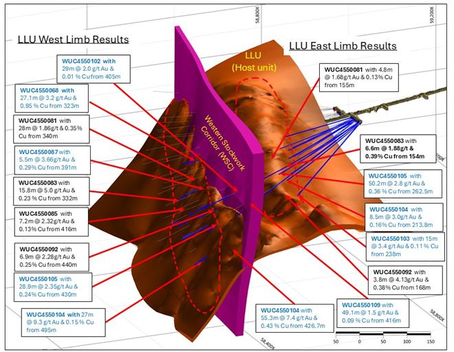
Figure 6: West Dome Underground Geological Section (looking north)
Regional Exploration
Greatland holds a significant portfolio of precious and base metals focused exploration and development projects in Western Australia, the focus of which is the Paterson region surrounding Telfer and Havieron.
Figure 7: Paterson region projects
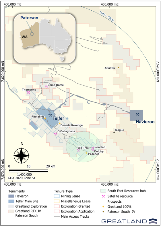
In H1 FY26 Greatland advanced extension drilling at several known satellite deposits on mining leases, within trucking distance of the Telfer processing plant, and considers them to have potential to provide ore feed to Telfer.
The main targets tested to date are the South-East Hub, Thomsons deposit 16km NE of the mill, Camp Dome deposit, ~16km north of the mill and the O'Callaghans tungsten-copper polymetallic skarn deposit (Figure 7).
Work has also been completed targeting prospects within the Paterson South project (the subject of a farm-in and joint venture arrangement between Greatland Paterson South Pty Ltd and Rio Tinto Exploration Pty Limited (RTX), under which Greatland is earning up to a 75% interest).
South-East Hub (SE Hub)
The SE Hub is located approximately 25km south-east of the Telfer Mine Site and hosts a cluster of three known deposits (Big Tree, Dolphy and Ironclad) that were historically reported as Mineral Resources by Telfer's previous owner Newcrest Mining Limited, but have not been declared as Mineral Resources by Greatland until adequate technical evaluation is conducted.
Drilling during the quarter has focused on testing for extensions down dip and along strike of the Big Tree deposit (Figure 8). Three of six planned diamond holes have been completed and one is in progress, for a total of 1,197m drilling. Assay results have been received for two holes and partial results for one.
Encouragingly, two holes drilled to the northeast and along strike of the historic resource intersected shallow mineralisation down dip from historic drilling. The program is planned to recommence in the June 2026 quarter.
Highlights to date include:
§ 5.38m @ 1.60g/t Au from 110.62m, including 0.25m @ 33.2g/t Au from 112.65m (BT25DD001)
§ 25m @ 0.24g/t Au from 124m (BT25DD002)
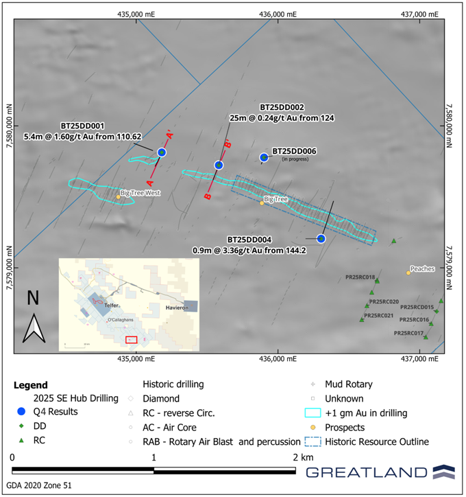 Figure 8: Big Tree plan view showing 2025 drill traces, peak intercepts per hole, historic mineralisation on Magnetics RTP image
Figure 9: Oblique section A showing results from hole BT25DD001 and historic drilling
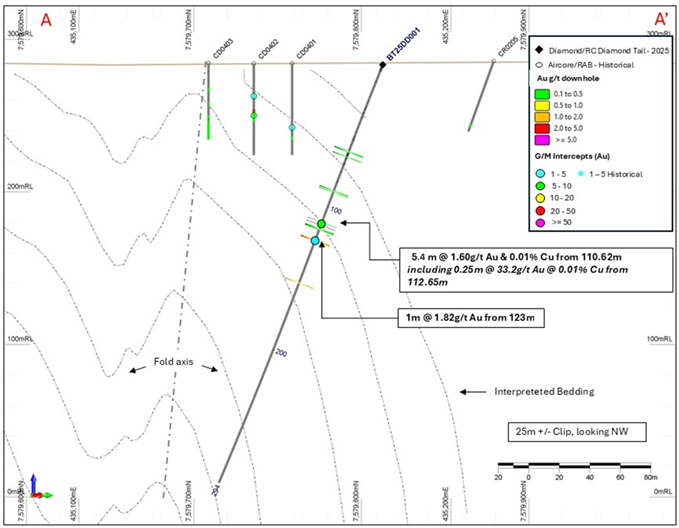
Figure 10: Oblique section B showing partial results from hole BT25DD002 and historic drilling.
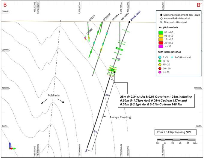
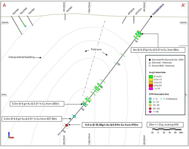
Thomsons
Thomsons is an historic deposit located approximately 14km northwest of Telfer on the western limb of a tight overturned anticlinal structure with mineralisation hosted in reef and stockworks analogous to Telfer Main and West Dome deposits. In September 2025, Greatland completed a seven hole drill program aimed at testing for Telfer style stacked reef and stockwork mineralisation beneath and along strike of shallow (<100m) historical mineralisation.
Assay results for the remaining three drillholes of the program have been received. The program has demonstrated potential for additional shallow mineralisation along strike and down dip of historic drilling and has identified a new high-grade east west oriented vein set that remains open along strike and down dip. The potential for stacked reef mineralisation at depth has been downgraded. These results will be used to refine the geological interpretation to guide future exploration targeting.
Highlights from new results include:
§ 0.6m @ 35.06g/t Au & 0.04% Cu from 478m (THO25RCD014)
§ 2.9m @ 2.35g/t Au & 0.06% Cu from 318.4m (THO25DD013)
Figure 11: Thomsons plan view showing 2025 drill traces, gold intercepts from 2025 and historical drilling with Magnetics RTP background image. Section line marked in red relates to Figure 12.
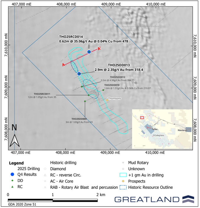
Figure 12: Oblique section A showing results from hole THO25RCD014 and historic drilling
O'Callaghans (Tungsten-Copper Deposit)
The O'Callaghan's deposit is a tungsten, copper, lead, and zinc sulphide deposit located approximately 10km south-southeast of the Telfer mine and a globally significant high grade tungsten deposit outside of China, and has historically been listed as both a Reserve and Mineral Resource by Telfer's previous owner, but was not declared as either a Reserve or a Mineral Resource by Greatland in its March 2025 update (four months post-acquisition of Telfer) as technical evaluations to support such classifications had not been completed at that time.
A 1,200m diamond drill hole was completed to advance the understanding of the structural architecture and geology beneath the deposit. The hole was co-funded through the WA Government Exploration Incentive Scheme (EIS) and was designed to test modelled magnetic anomalies and seismic reflectors beneath the mineralised skarn. The drilling has provided valuable geological and structural information that will support ongoing interpretation and exploration work. Assay results from the program are pending.
Camp Dome
The Camp Dome prospect is a satellite copper-only oxide deposit located approximately 20km north of the Telfer mine. The deposit was historically reported as a Mineral Resource by Telfer's previous owner Newcrest Mining Limited, but has not been declared as a Mineral Resource by Greatland until adequate technical evaluation is conducted.
Drilling has commenced testing for extensions to primary copper mineralisation below the oxide deposit. Two diamond holes and two pre-collars have been completed for a total of 1,430m, partial assay results have received for two holes.
Highlights to date include:
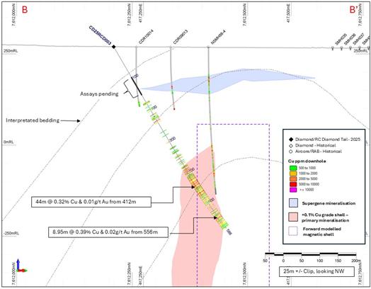
§ 44.4 m @ 0.32% Cu & 0.01g/t Au from 412m (CD25RCD003)
§ 7m @ 0.81% Cu & 0.02g/t Au from 106m (CD25DD002)
§ 19.8m @ 0.32% Cu & 0.01g/t Au from 147.8m CD25DD002
Although preliminary, results to date have confirmed grade continuity through the supergene and primary mineralisation models, a full review will be conducted when remaining assay results have been received. The program has been temporary placed on hold until the end of the wet season, and it is anticipated to resume in the June 2026 quarter.
Figure 13: Camp Dome plan view showing 2025 drilling and peak copper intercepts on RTP magnetics
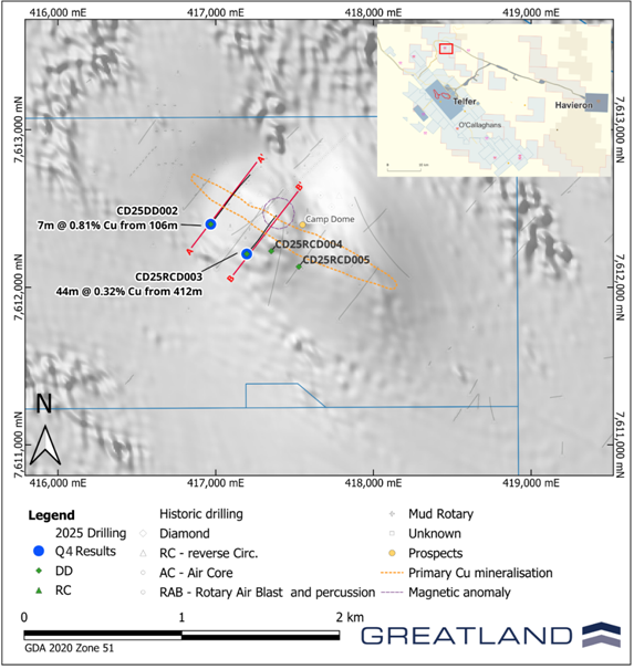
Figure 14: Oblique section A showing results from hole CD25DD002, historic drilling and copper mineralisation interpretations
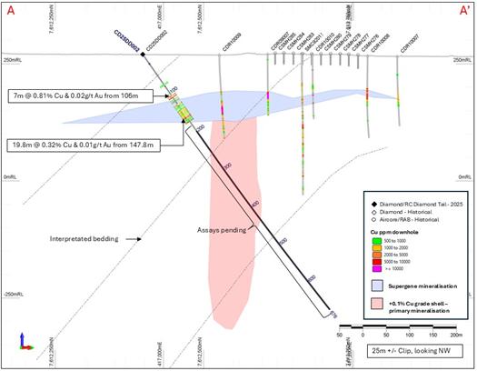
Figure 15: Oblique section B showing results from hole CD25RCD003, historic drilling and copper mineralisation interpretations
Pinnacles
The Pinnacles prospect is located approximately 1km southeast of the West Dome open pit, along the trend of the West Dome anticline structure (Figure 7).
Drilling is currently underway targeting the western limb of the Lower Limey Unit (LLU) unit, host to multiple ore bodies at Telfer's West Dome and Main Dome open pits and undergrounds, 1km along strike from previous drilling.
Paterson South Farm-In & Joint Venture
The Paterson South Project consists of seven exploration tenements which cover a combined area of 1,080km2 (shown in Figure 7).
The Paterson South Project is the subject of a farm-in and joint venture arrangement between Greatland Paterson South Pty Ltd and Rio Tinto Exploration Pty Limited (RTX), a subsidiary of Rio Tinto Limited (ASX/LSE:RIO), to accelerate exploration across the tenure in the Paterson region
Farm-In milestone
During the December quarter, Greatland completed the Stage 1 Farm-In by spending $7.1 million and completing drilling of at least 7,500m in aggregate, earning a 51% interest in the Paterson South Project tenements and forming an unincorporated joint venture with RTX over that project (Greatland 51% : RTX 49%). Greatland is the joint venture manager.
RTX is currently considering whether to exercise its right to contribute to its 51% share of future joint venture expenditure. If RTX does not exercise this right, Greatland intends to sole fund the Stage 2 Farm-In requirements, allowing Greatland to earn up to a 75% joint venture interest.
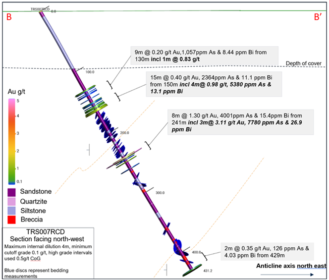
Teague
RC and diamond drill (DD) testing of geological, magnetic and structural targets at the Teague prospect (Figure 16) was completed, with 3 holes drilled for 1,240.1m.
Drilling targeted an interpreted anticlinal fold structure which hosts mineralisation further along strike to the northwest at the Triangle prospect (Figure 16). Three drill holes were completed in late 2024. Holes TRS002RCD and TRS004RCD intersected zones of variably anomalous Au, Cu, Bi and As mineralisation associated with brecciated, reef style quartz veining and associated sericite, hematite and carbonate alteration. Three RC pre-collared DD tailed holes were drilled to follow up this mineralisation.
Figure 16: Teague prospect, Triangle South; completed holes on reduced to pole 1st vertical derivative aeromagnetic image, with drill section lines in pink
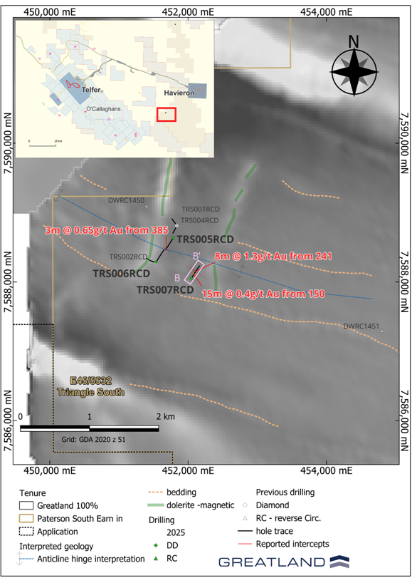
Drilling successfully intersected similar style Au - Cu - As - Bi mineralisation, associated with zones of massive to semi-massive pyrite rich sulphide, with traces of arsenopyrite and chalcopyrite, observed within sericite-carbonate altered, brecciated, stockwork quartz veined fine grained sandstones.
Mineralised intercepts received to date include:
§ 8m @ 1.30g/t Au from 241m (incl. 3m @ 3.11 g/t Au from 241m) (TRS007RCD)
§ 15m @ 0.40g/t Au from 150m (incl. 4m @ 0.98g/t Au from 161m) (TRS007RCD)
§ 3m @ 0.65g/t Au from 385m (incl. 1m @ 1.58g/t Au from 385m) (TRS005RCD)
Results from drillhole TRS006RCD are pending.
Further detailed interpretation of the lithogeochemistry, pathfinder anomalism, geology and structure will be completed once all assays are returned.
Follow up work will be planned for testing of the continuity and orientation of the mineralised zones intersected to date, with over 500m of strike between the two drill lines completed at Teague by Greatland (Figure 16). Mineralisation is open down and up dip, and along strike to the northwest and southeast.
(Figure 16). Mineralisation is open down and up dip, and along strike to the northwest and southeast.
Figure 17: Oblique section B showing results from hole TRS007RCD; interpreted structures, anomalous assays and geology
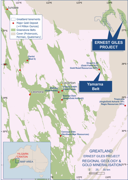
Ernest Giles Project
Greatland's 100% owned Ernest Giles project (Figure 18) is located in the Eastern Goldfields region of Western Australia, 250km northeast of Laverton.
Figure 18: Ernest Giles Project and Yamarna Belt location
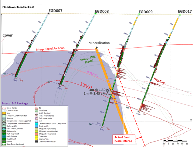
Exploration work completed in 2025 was focused on the Meadows target area situated in the south-east end of the Ernest Giles Greenstone belt. The diamond drilling component of the program was completed during the quarter, with 11 holes for 2,195.8m, giving a total of 20 RC and RCD holes for 7,479.1m over several target areas, within the Meadows prospect.
Encouraging anomalous gold intersections have been returned from the recently completed DD tails and are being analysed. Results include:
§ 9m @ 0.72g/t Au from 349m (EGD009) including;
- 3m @ 1.30 g/t Au from 349m; and
- 1m @ 2.43 g/t Au from 354m
Results for the last seven diamond core tails are still pending.
Mineralisation appears to be stratabound within ironstones (BIF) which dip at ~65o toward 025o, matching the long axis of the IP anomaly and approximating the magnetic trend (Figure 19).
It is likely that the drill line to the north did not intersect the mineralised zone, as the zone is cut off by the younger cover sequence in hole EGD011 on that line (Figure 19). The zone is open up-dip and to the north and south. Follow up drill plans will be confirmed once all assays have been returned and interpreted.
Figure 19:1 Meadows Prospect - showing schematic identified mineralisation in BIFs in EGD009 on prioritised DD tails, existing drilling, geology and IP anomalies
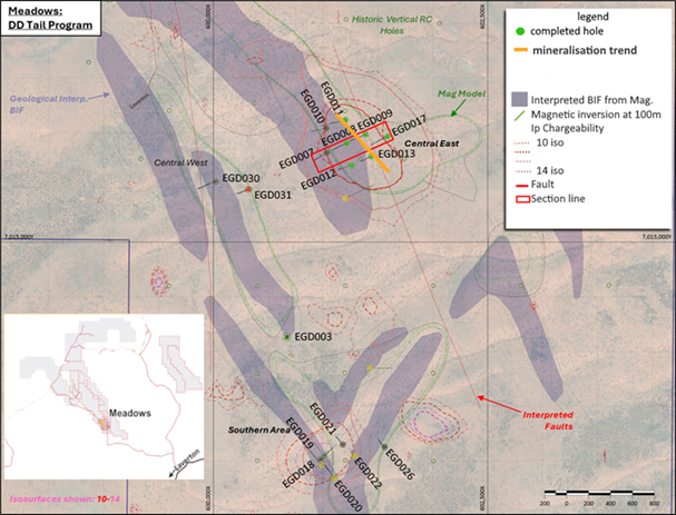
Figure 20: Meadows prospect, oblique section B showing results from hole EGD007-009; looking 335o; interpreted structures, geophysical models, anomalous assays and geology
Contact
For further information, please contact:
Greatland Resources Limited
Shaun Day, Managing Director | Rowan Krasnoff, Chief Development Officer
Nominated Advisor
SPARK Advisory Partners
Andrew Emmott / James Keeshan / Neil Baldwin | +44 203 368 3550
Corporate Brokers
Canaccord Genuity | James Asensio / George Grainger | +44 207 523 8000
RBC Capital Markets | James Agnew / Jamil Miah | Scott Redwood | +44 207 029 0528
Media Relations
Australia - Fivemark Partners | Michael Vaughan | +61 422 602 720
About Greatland
Greatland is a gold and copper mining company listed on the Australian Securities Exchange and London Stock Exchange's AIM Market (ASX:GGP and AIM:GGP) and operates its business from Western Australia.
The Greatland portfolio includes the 100% owned Telfer mine, the adjacent 100% owned brownfield world-class Havieron gold-copper development project, and a significant exploration portfolio within the surrounding region. The combination of Telfer and Havieron provides for a substantial and long life gold-copper operation in the Paterson Province in the East Pilbara region of Western Australia.
Forward Looking Statements
This document includes forward looking statements and forward looking information within the meaning of securities laws of applicable jurisdictions. Forward looking statements can generally be identified by the use of words such as "may", "will", "expect", "intend", "plan", "estimate", "anticipate", "believe", "continue", "objectives", "targets", "outlook" and "guidance", or other similar words and may include, without limitation, statements regarding estimated reserves and resources, certain plans, strategies, aspirations and objectives of management, anticipated production, study or construction dates, expected costs, cash flow or production outputs and anticipated productive lives of projects and mines.
These forward looking statements involve known and unknown risks, uncertainties and other factors that may cause actual results, performance and achievements or industry results to differ materially from any future results, performance or achievements, or industry results, expressed or implied by these forward-looking statements. Relevant factors may include, but are not limited to, changes in commodity prices, foreign exchange fluctuations and general economic conditions, increased costs and demand for production inputs, the speculative nature of exploration and project development, including the risks of obtaining necessary licences and permits and diminishing quantities or grades of reserves, political and social risks, changes to the regulatory framework within which Greatland operates or may in the future operate, environmental conditions including extreme weather conditions, recruitment and retention of personnel, industrial relations issues and litigation.
Forward looking statements are based on assumptions as to the financial, market, regulatory and other relevant environments that will exist and affect Greatland's business and operations in the future. Greatland does not give any assurance that the assumptions will prove to be correct. There may be other factors that could cause actual results or events not to be as anticipated, and many events are beyond the reasonable control of Greatland. Forward looking statements in this document speak only at the date of issue. Greatland does not undertake any obligation to update or revise any of the forward looking statements or to advise of any change in assumptions on which any such statement is based.
Competent Persons Statement
Information in the report pertaining to Telfer Resource Development exploration results has been reviewed and approved by Mr Michael Thomson, a Member of the Australian Institute of Geoscientists (AIG), who has more than 20 years relevant industry experience. Mr Thomson, an employee of the Company, has sufficient experience relevant to the style of mineralisation, type of deposit under consideration, and to the activity which he is undertaking to qualify as a Competent Person as defined by the 2012 Edition of the Australasian Code for Reporting of Exploration Results, Mineral Resources and Ore Reserves (the JORC Code) and under the AIM Rules - Note for Mining and Oil & Gas Companies, which outline standards of disclosure for mineral projects. Mr Thomson consents to the inclusion in this announcement of the matters based on this information in the form and context in which it appears.
Information in the report pertaining to Regional Exploration results has been reviewed and approved by Mr Damien Stephens, a Member of the Australian Institute of Mining and Metallurgy (AusIMM)), who has more than 30 years relevant industry experience. Mr Stephens, an employee of the Company, has sufficient experience relevant to the style of mineralisation, type of deposit under consideration, and to the activity which he is undertaking to qualify as a Competent Person as defined by the 2012 Edition of the Australasian Code for Reporting of Exploration Results, Mineral Resources and Ore Reserves (the JORC Code) and under the AIM Rules - Note for Mining and Oil & Gas Companies, which outline standards of disclosure for mineral projects. Mr Stephens consents to the inclusion in this announcement of the matters based on this information in the form and context in which it appears.
Telfer Resource Development Drillhole Data and Au- Cu Significant Intersections
Reporting Criteria: Intercepts reported are downhole drill width (not true width) Au >0.5ppm (0.5g/t Au) and minimum 1m downhole width with maximum consecutive internal dilution of 5m. Average grades are based on length-weighting of samples grade, and only those intercepts with a gram metres (Au_ppm x length) above 10 gram metres have been reported. Gold and copper grades are reported to two significant figures, the downhole lengths are rounded to 0.1m which may cause some apparent discrepancies in interval widths. Underground samples are from core drilling which is NQ2 in diameter while open pit samples are from reverse circulation (RC) drilling.
Regional Exploration Drillhole Data and Au- Cu Significant Intersections
Reporting Criteria: Intercepts reported are downhole drill width (not true width) Au >0.2ppm (0.2g/t Au) for Telfer near mine exploration (Telfer Expl.) and Au >0.1 g/t Au for other projects and minimum 0.1m downhole width with maximum consecutive internal dilution of 5m. Average grades are based on length-weighting of samples grade, and only those intercepts with a gram metres (Au_ppm x length) above 1 gram metres have been reported. Gold and copper grades are reported to two significant figures, the downhole lengths are rounded to 0.1m which may cause some apparent discrepancies in interval widths. Samples are from RC and diamond drilling both HQ and NQ diameter.
Intercepts reported for Camp Dome are downhole drill width (not true width) Cu >0.3% Cu and minimum 0.1m downhole width with maximum consecutive internal dilution of 5m. Average grades are based on length-weighting of samples grade, and only those intercepts with widths a percent (%) metre (Cu % x length) above 3% metres have been reported.
Table 1: Telfer Resource Development significant intercepts & drilling data (Mine Grid)
Area | HOLEID | EAST | NORTH | RL | Depth | Dip | Azimuth | From | Too | Width | Au ppm | Cu pct | Au (GM) |
WDU | WUC4550068 | 13072 | 58783 | 4421 | 391 | 9 | 273 | 323.0 | 350.1 | 27.1 | 3.23 | 0.95 | 88 |
WDU | WUC4550068 | 13072 | 58783 | 4421 | 391 | 9 | 273 | 157.8 | 186.0 | 28.2 | 1.00 | 0.10 | 28 |
WDU | WUC4550068 | 13072 | 58783 | 4421 | 391 | 9 | 273 | 239.0 | 249.8 | 10.8 | 1.54 | 0.11 | 17 |
WDU | WUC4550081 | 13067 | 58782 | 4421 | 412 | 14 | 273 | 155.0 | 159.8 | 4.8 | 1.68 | 0.13 | 8 |
WDU | WUC4550081 | 13067 | 58782 | 4421 | 412 | 14 | 273 | 309.0 | 333.0 | 24.0 | 1.18 | 0.09 | 28 |
WDU | WUC4550081 | 13067 | 58782 | 4421 | 412 | 14 | 273 | 341.0 | 369.0 | 28.0 | 1.85 | 0.35 | 52 |
WDU | WUC4550082 | 13065 | 58782 | 4422 | 398 | 9 | 268 | 233.5 | 243.0 | 9.5 | 1.37 | 0.05 | 13 |
WDU | WUC4550082 | 13065 | 58782 | 4422 | 398 | 9 | 268 | 337.0 | 361.0 | 24.0 | 1.99 | 1.61 | 48 |
WDU | WUC4550083 | 13066 | 58782 | 4421 | 466 | 17 | 268 | 154.7 | 161.3 | 6.7 | 1.88 | 0.39 | 12 |
WDU | WUC4550083 | 13066 | 58782 | 4421 | 466 | 17 | 268 | 391.6 | 397.2 | 5.5 | 3.66 | 0.28 | 20 |
WDU | WUC4550083 | 13066 | 58782 | 4421 | 466 | 17 | 268 | 335.0 | 391.6 | 56.6 | 2.28 | 1.23 | 129 |
WDU | WUC4550084 | 13066 | 58782 | 4421 | 422 | 18 | 272 | 368.0 | 398.1 | 30.1 | 1.64 | 0.48 | 49 |
WDU | WUC4550085 | 13067 | 58782 | 4421 | 447 | 23 | 272 | 416.0 | 423.2 | 7.15 | 2.32 | 0.13 | 17 |
WDU | WUC4550085 | 13067 | 58782 | 4421 | 447 | 23 | 272 | 334.0 | 400.5 | 66.5 | 1.17 | 0.16 | 78 |
WDU | WUC4550087 | 13059 | 58783 | 4422 | 427 | 13 | 264 | 332.0 | 347.8 | 15.8 | 5.01 | 0.23 | 79 |
WDU | WUC4550087 | 13059 | 58783 | 4422 | 427 | 13 | 264 | 166.0 | 182.0 | 16.0 | 1.39 | 0.30 | 22 |
WDU | WUC4550087 | 13059 | 58783 | 4422 | 427 | 13 | 264 | 311.0 | 319.0 | 8.0 | 2.60 | 0.07 | 21 |
WDU | WUC4550087 | 13059 | 58783 | 4422 | 427 | 13 | 264 | 279.5 | 280.7 | 1.2 | 14.81 | 0.00 | 17 |
WDU | WUC4550087 | 13059 | 58783 | 4422 | 427 | 13 | 264 | 385.0 | 387.3 | 2.3 | 4.95 | 0.17 | 11 |
WDU | WUC4550092 | 13053 | 58783 | 4421 | 535 | 21 | 264 | 167.8 | 171.6 | 3.8 | 4.13 | 0.38 | 16 |
WDU | WUC4550092 | 13053 | 58783 | 4421 | 535 | 21 | 264 | 440.2 | 447.1 | 6.8 | 2.28 | 0.26 | 16 |
WDU | WUC4550092 | 13053 | 58783 | 4421 | 535 | 21 | 264 | 358.0 | 440.2 | 82.2 | 1.9 | 0.31 | 156 |
WDU | WUC4550098 | 13044 | 58783 | 4422 | 450 | 8 | 251 | 322.5 | 335.7 | 13.2 | 0.91 | 0.03 | 12 |
WDU | WUC4550098 | 13044 | 58783 | 4422 | 450 | 8 | 251 | 375.0 | 407.0 | 32 | 1.0 | 0.06 | 32 |
WDU | WUC4550098 | 13044 | 58783 | 4422 | 450 | 8 | 251 | 344.0 | 349.0 | 5.0 | 5.67 | 0.01 | 28 |
WDU | WUC4550102 | 13036 | 58784 | 4422 | 509 | 8 | 250 | 405.0 | 434.0 | 29.0 | 2.00 | 0.01 | 58 |
WDU | WUC4550102 | 13036 | 58784 | 4422 | 509 | 8 | 250 | 350.0 | 361.6 | 11.6 | 2.97 | 1.13 | 34 |
WDU | WUC4550102 | 13036 | 58784 | 4422 | 509 | 8 | 250 | 209.4 | 222.0 | 12.6 | 1.39 | 0.13 | 17 |
WDU | WUC4550103 | 13036 | 58784 | 4422 | 553 | 16 | 252 | 238.0 | 253.0 | 15.0 | 3.41 | 0.11 | 51 |
WDU | WUC4550103 | 13036 | 58784 | 4422 | 553 | 16 | 252 | 294.4 | 296.0 | 1.6 | 13.20 | 0.01 | 21 |
WDU | WUC4550104 | 13037 | 58783 | 4422 | 539 | 20 | 252 | 426.7 | 482.0 | 55.3 | 7.44 | 0.43 | 411 |
WDU | WUC4550104 | 13037 | 58783 | 4422 | 539 | 20 | 252 | 495.0 | 522.0 | 27.0 | 9.25 | 0.15 | 250 |
WDU | WUC4550104 | 13037 | 58783 | 4422 | 539 | 20 | 252 | 213.9 | 222.3 | 8.5 | 3.04 | 0.16 | 26 |
WDU | WUC4550104 | 13037 | 58783 | 4422 | 539 | 20 | 252 | 403.2 | 420.0 | 16.8 | 0.96 | 0.13 | 16 |
WDU | WUC4550105 | 13037 | 58783 | 4422 | 506 | 11 | 251 | 262.5 | 312.7 | 50.2 | 2.78 | 0.36 | 140 |
WDU | WUC4550105 | 13037 | 58783 | 4422 | 506 | 11 | 251 | 430.0 | 458.9 | 28.9 | 2.35 | 0.24 | 68 |
WDU | WUC4550105 | 13037 | 58783 | 4422 | 506 | 11 | 251 | 320.0 | 326.0 | 6.0 | 1.87 | 0.07 | 11 |
WDU | WUC4550109 | 13031 | 58783 | 4422 | 542 | 7 | 241 | 416.0 | 465.1 | 49.1 | 1.45 | 0.09 | 71 |
WDU | WUC4550109 | 13031 | 58783 | 4422 | 542 | 7 | 241 | 470.7 | 473.0 | 2.3 | 8.56 | 0.10 | 20 |
Main Dome | MUC4540086 | 11815 | 60394 | 4558 | 120 | -44 | 172 | 49.0 | 98.8 | 49.8 | 1.20 | 0.07 | 60 |
Main Dome | MUC4540093 | 11818 | 60387 | 4559 | 85 | -60 | 8 | 28.0 | 45.0 | 17.0 | 3.07 | 0.09 | 52 |
Main Dome | MUC4540096 | 11857 | 60350 | 4557 | 86 | -43 | 272 | 28.0 | 50.1 | 22.1 | 1.78 | 0.31 | 39 |
Main Dome | MUC4540090 | 11821 | 60388 | 4558 | 110 | -63 | 316 | 67.0 | 97.0 | 30.0 | 1.27 | 0.13 | 38 |
Main Dome | MUC4540090 | 11821 | 60388 | 4558 | 110 | -63 | 316 | 34.0 | 38.0 | 4.0 | 8.88 | 0.59 | 36 |
Main Dome | MUC4540083 | 11826 | 60391 | 4555 | 170 | -7 | 41 | 0.0 | 9.7 | 9.7 | 3.55 | 0.34 | 34 |
Main Dome | MUC4540076 | 11865 | 60295 | 4549 | 56 | -72 | 103 | 26.0 | 36.0 | 10.0 | 2.89 | 0.87 | 29 |
Main Dome | MUC4540078 | 11860 | 60286 | 4549 | 100 | -63 | 192 | 8.3 | 28.2 | 19.9 | 1.35 | 0.62 | 27 |
Main Dome | MUC4540095 | 11858 | 60353 | 4559 | 80 | -83 | 285 | 70.0 | 77.5 | 7.5 | 3.48 | 1.04 | 26 |
Main Dome | MUC4540084 | 11826 | 60392 | 4555 | 42 | -6 | 71 | 0.7 | 11.8 | 11.1 | 2.29 | 0.05 | 25 |
Main Dome | MUC4540093 | 11818 | 60387 | 4559 | 85 | -60 | 8 | 51.0 | 61.3 | 10.3 | 2.27 | 0.12 | 23 |
Main Dome | MUC4540094 | 11852 | 60357 | 4558 | 80 | -79 | 296 | 26.3 | 34.0 | 7.7 | 2.69 | 0.38 | 21 |
Main Dome | MUC4540098a | 11854 | 60375 | 4557 | 105 | -29 | 326 | 38.0 | 51.0 | 13.0 | 1.55 | 0.66 | 20 |
Main Dome | MUC4540097 | 11859 | 60353 | 4559 | 80 | -79 | 63 | 23.0 | 29.3 | 6.3 | 3.06 | 0.56 | 19 |
Main Dome | MUC4540091 | 11819 | 60387 | 4559 | 77 | -62 | 265 | 38.0 | 42.0 | 4.0 | 4.80 | 2.12 | 19 |
Main Dome | MUC4540101 | 11838 | 60381 | 4559 | 64 | -67 | 28 | 28.7 | 39.3 | 10.6 | 1.73 | 0.06 | 18 |
Main Dome | MUC4540085 | 11827 | 60391 | 4557 | 84 | -43 | 29 | 66.0 | 84.2 | 18.2 | 0.96 | 0.25 | 18 |
Main Dome | MUC4540090 | 11821 | 60388 | 4558 | 110 | -63 | 316 | 101.0 | 105.0 | 4.0 | 3.75 | 0.22 | 15 |
Main Dome | MUC4540098a | 11854 | 60375 | 4557 | 105 | -29 | 326 | 87.6 | 99.2 | 11.6 | 1.21 | 0.02 | 14 |
Main Dome | MUC4540095 | 11858 | 60353 | 4559 | 80 | -83 | 285 | 23.0 | 30.0 | 7.0 | 1.79 | 0.57 | 13 |
Main Dome | MUC4540086 | 11815 | 60394 | 4558 | 120 | -44 | 172 | 105.0 | 120.0 | 15.0 | 0.78 | 0.11 | 12 |
Main Dome | MUC4540076 | 11865 | 60295 | 4549 | 56 | -72 | 103 | 7.1 | 15.1 | 7.9 | 1.47 | 0.28 | 12 |
Main Dome | MUC4641017 | 11267 | 60291 | 4642 | 60 | 23 | 36 | 23.7 | 24.4 | 0.7 | 25.37 | 3.38 | 18 |
Main Dome | MUC4641017 | 11267 | 60291 | 4642 | 60 | 23 | 36 | 49.5 | 56.8 | 7.4 | 1.48 | 0.44 | 11 |
Main Dome | MUC4641018 | 11266 | 60291 | 4643 | 53 | 23 | 95 | 20.9 | 21.7 | 0.9 | 78.11 | 7.23 | 66 |
Main Dome | MUC4648002 | 11246 | 60264 | 4649 | 74 | 30 | 100 | 67.9 | 72.0 | 4.1 | 2.95 | 0.12 | 12 |
Main Dome | MUC4654021 | 11422 | 60133 | 4698 | 175 | 48 | 186 | 78.0 | 80.0 | 2.0 | 5.86 | 0.01 | 12 |
Main Dome | MUC4681006 | 11655 | 60173 | 4684 | 90 | 23 | 33 | 86.9 | 88.0 | 1.1 | 54.67 | 0.13 | 60 |
Main Dome | MUC4681009 | 11655 | 60173 | 4684 | 96 | 16 | 24 | 0.0 | 1.0 | 1.0 | 19.04 | 0.80 | 19 |
Main Dome | MUC4681009 | 11655 | 60173 | 4684 | 96 | 16 | 24 | 76.8 | 77.8 | 1.0 | 19.61 | 1.19 | 19 |
Main Dome | MUC4848027 | 11121 | 61031 | 4856 | 65 | -42 | 85 | 45.0 | 53.0 | 8.0 | 6.65 | 0.88 | 53 |
Main Dome | MUC4848029 | 11118 | 61031 | 4856 | 65 | -58 | 99 | 20.0 | 49.0 | 29.0 | 1.67 | 0.28 | 48 |
Main Dome | MUC4848021 | 11108 | 61027 | 4857 | 75 | -84 | 273 | 34.0 | 64.0 | 30.0 | 1.53 | 0.11 | 46 |
Main Dome | MUC4848026 | 11120 | 61027 | 4857 | 60 | -86 | 87 | 28.0 | 57.0 | 29.0 | 1.47 | 0.12 | 43 |
Main Dome | MUC4848003 | 11036 | 61016 | 4857 | 90 | -38 | 125 | 74.0 | 81.0 | 7.0 | 5.91 | 0.55 | 41 |
Main Dome | MUC4848024 | 11108 | 61030 | 4855 | 60 | -38 | 90 | 52.0 | 59.1 | 7.1 | 5.76 | 2.38 | 41 |
Main Dome | MUC5066061 | 11110 | 61115 | 5057 | 210 | 76 | 266 | 161.1 | 175.0 | 13.9 | 2.82 | 1.07 | 39 |
Main Dome | MUC4848030 | 11127 | 61029 | 4857 | 70 | -82 | 278 | 29.0 | 50.0 | 21.0 | 1.56 | 0.11 | 33 |
Main Dome | MUC4848007 | 11081 | 61023 | 4856 | 68 | -80 | 297 | 53.4 | 67.0 | 13.6 | 2.32 | 0.17 | 32 |
Main Dome | MUC4848012 | 11077 | 61024 | 4856 | 70 | -72 | 280 | 50.3 | 69.0 | 18.7 | 0.95 | 0.21 | 18 |
Main Dome | MUC4848031 | 11139 | 61028 | 4857 | 70 | -82 | 275 | 38.0 | 45.0 | 7.0 | 2.24 | 0.14 | 16 |
Main Dome | MUC4848031 | 11139 | 61028 | 4857 | 70 | -82 | 275 | 52.4 | 70.0 | 17.6 | 0.81 | 0.11 | 14 |
Main Dome | MUC4848007 | 11081 | 61023 | 4856 | 68 | -80 | 297 | 36.0 | 38.2 | 2.2 | 5.46 | 0.05 | 12 |
Main Dome | MUC4848024 | 11108 | 61030 | 4855 | 60 | -38 | 90 | 30.0 | 31.0 | 1.0 | 10.38 | 0.09 | 10 |
Main Dome | MUC4848004 | 11040 | 61012 | 4858 | 67 | -70 | 290 | 53.0 | 66.0 | 13.0 | 0.78 | 0.05 | 10 |
West Dome | WR28748 | 12882 | 58057 | 5524 | 308 | 63 | 53 | 273.0 | 308.0 | 35.0 | 4.76 | 0.30 | 167 |
West Dome | WR24227 | 12421 | 58500 | 5503 | 240 | 90 | 326 | 168.0 | 190.0 | 22.0 | 2.95 | 0.33 | 65 |
West Dome | WR27230 | 12726 | 58448 | 5204 | 192 | 57 | 211 | 10.0 | 59.0 | 49.0 | 0.95 | 0.09 | 47 |
West Dome | WR24226 | 12423 | 58474 | 5505 | 258 | 90 | 357 | 146.0 | 184.0 | 38.0 | 1.09 | 0.27 | 42 |
West Dome | WR39551 | 13950 | 58851 | 5504 | 210 | 79 | 95 | 147.0 | 192.0 | 45.0 | 0.91 | 0.07 | 41 |
West Dome | WR39552 | 13960 | 58883 | 5496 | 216 | 75 | 94 | 121.0 | 162.0 | 41.0 | 0.99 | 0.02 | 41 |
West Dome | WR25707 | 12573 | 58140 | 5523 | 414 | 56 | 74 | 403.0 | 414.0 | 11.0 | 3.23 | 0.10 | 36 |
West Dome | WR39219 | 13923 | 58886 | 5496 | 240 | 82 | 270 | 159.0 | 201.0 | 42.0 | 0.84 | 0.21 | 35 |
West Dome | WR40079 | 14008 | 58852 | 5496 | 240 | 84 | 96 | 166.0 | 202.0 | 36.0 | 0.97 | 0.24 | 35 |
West Dome | WR39554 | 13951 | 58787 | 5505 | 204 | 76 | 95 | 58.0 | 78.0 | 20.0 | 1.63 | 0.07 | 33 |
West Dome | WR30777 | 13071 | 58251 | 5315 | 156 | 90 | 177 | 98.0 | 108.0 | 10.0 | 3.14 | 0.12 | 31 |
West Dome | WR31281 | 13124 | 58391 | 5251 | 125 | 89 | 127 | 1.0 | 6.0 | 5.0 | 5.98 | 0.28 | 30 |
West Dome | WR38554 | 13872 | 58811 | 5504 | 150 | 70 | 273 | 88.0 | 90.0 | 2.0 | 12.15 | 0.47 | 24 |
West Dome | WR27595 | 12753 | 58415 | 5204 | 120 | 78 | 272 | 28.0 | 66.0 | 38.0 | 0.63 | 0.07 | 24 |
West Dome | WR40737 | 14076 | 58814 | 5497 | 258 | 68 | 95 | 168.0 | 210.0 | 42.0 | 0.55 | 0.02 | 23 |
West Dome | WR38230 | 13821 | 58797 | 5504 | 135 | 90 | 170 | 64.0 | 77.0 | 13.0 | 1.77 | 0.06 | 23 |
West Dome | WR31766 | 13170 | 58284 | 5306 | 184 | 75 | 94 | 44.0 | 48.0 | 4.0 | 5.41 | 0.07 | 22 |
West Dome | WR31169 | 13107 | 58311 | 5289 | 183 | 74 | 360 | 85.0 | 104.0 | 19.0 | 1.12 | 0.09 | 21 |
West Dome | WR40736 | 14071 | 58849 | 5504 | 252 | 73 | 101 | 167.0 | 187.0 | 20.0 | 1.03 | 0.03 | 21 |
West Dome | WR38555 | 13869 | 58772 | 5504 | 60 | 74 | 273 | 26.0 | 57.0 | 31.0 | 0.66 | 0.01 | 21 |
West Dome | WR33156 | 13310 | 58327 | 5301 | 150 | 63 | 18 | 58.0 | 79.0 | 21.0 | 0.95 | 0.06 | 20 |
West Dome | WR33157 | 13309 | 58327 | 5301 | 150 | 81 | 358 | 49.0 | 63.0 | 14.0 | 1.40 | 0.04 | 20 |
West Dome | WR39226 | 13928 | 59106 | 5504 | 180 | 57 | 274 | 27.0 | 33.0 | 6.0 | 3.26 | 0.00 | 20 |
West Dome | WR38228 | 13824 | 58851 | 5504 | 200 | 90 | 353 | 166.0 | 190.0 | 24.0 | 0.75 | 0.06 | 18 |
West Dome | WR39555 | 13947 | 58771 | 5505 | 222 | 68 | 95 | 122.0 | 138.0 | 16.0 | 1.10 | 0.12 | 18 |
West Dome | WR31766 | 13170 | 58284 | 5306 | 184 | 75 | 94 | 96.0 | 115.0 | 19.0 | 0.90 | 0.02 | 17 |
West Dome | WR33156 | 13310 | 58327 | 5301 | 150 | 63 | 18 | 43.0 | 48.0 | 5.0 | 3.41 | 0.02 | 17 |
West Dome | WR41053 | 14102 | 58866 | 5497 | 230 | 55 | 96 | 160.0 | 162.0 | 2.0 | 8.50 | 0.28 | 17 |
West Dome | WR41242 | 14126 | 58843 | 5496 | 246 | 56 | 93 | 106.0 | 127.0 | 21.0 | 0.77 | 0.03 | 16 |
West Dome | WR28575 | 12846 | 58714 | 5411 | 390 | 73 | 275 | 130.0 | 144.0 | 14.0 | 1.14 | 0.01 | 16 |
West Dome | WR39058 | 13903 | 58883 | 5504 | 240 | 79 | 94 | 198.0 | 218.0 | 20.0 | 0.79 | 0.18 | 16 |
West Dome | WR39227 | 13928 | 59107 | 5504 | 180 | 78 | 277 | 110.0 | 114.0 | 4.0 | 3.91 | 0.01 | 16 |
West Dome | WR28752 | 12874 | 58811 | 5420 | 190 | 73 | 284 | 60.0 | 68.0 | 8.0 | 1.92 | 0.01 | 15 |
West Dome | WR25050 | 12511 | 58202 | 5521 | 432 | 74 | 79 | 214.0 | 221.0 | 7.0 | 2.12 | 0.13 | 15 |
West Dome | WR25117 | 12516 | 58197 | 5522 | 400 | 75 | 73 | 384.0 | 398.0 | 14.0 | 1.05 | 0.04 | 15 |
West Dome | WR28264 | 12821 | 58680 | 5408 | 330 | 76 | 290 | 268.0 | 287.0 | 19.0 | 0.77 | 0.01 | 15 |
West Dome | WR39553 | 13950 | 58786 | 5505 | 222 | 84 | 91 | 34.0 | 40.0 | 6.0 | 2.42 | 0.01 | 15 |
West Dome | WR39552 | 13960 | 58883 | 5496 | 216 | 75 | 94 | 43.0 | 52.0 | 9.0 | 1.58 | 0.02 | 14 |
West Dome | WR41243 | 14123 | 58810 | 5496 | 300 | 73 | 103 | 224.0 | 239.0 | 15.0 | 0.94 | 0.10 | 14 |
West Dome | WR40226 | 14021 | 58866 | 5497 | 204 | 90 | 260 | 163.0 | 187.0 | 24.0 | 0.58 | 0.03 | 14 |
West Dome | WR26305 | 12633 | 58100 | 5524 | 330 | 66 | 80 | 256.0 | 264.0 | 8.0 | 1.72 | 0.58 | 14 |
West Dome | WR27911 | 12801 | 58677 | 5406 | 366 | 74 | 293 | 239.0 | 247.0 | 8.0 | 1.71 | 0.26 | 14 |
West Dome | WR41053 | 14102 | 58866 | 5497 | 230 | 55 | 96 | 66.0 | 84.0 | 18.0 | 0.76 | 0.03 | 14 |
West Dome | WR33250 | 13319 | 58346 | 5300 | 180 | 90 | 311 | 50.0 | 75.0 | 25.0 | 0.54 | 0.04 | 14 |
West Dome | WR40557 | 14054 | 58817 | 5497 | 233 | 84 | 101 | 218.0 | 233.0 | 15.0 | 0.90 | 0.02 | 14 |
West Dome | WR25050 | 12511 | 58202 | 5521 | 432 | 74 | 79 | 309.0 | 316.0 | 7.0 | 1.92 | 0.04 | 13 |
West Dome | WR39735 | 13977 | 58778 | 5504 | 258 | 81 | 97 | 72.0 | 85.0 | 13.0 | 1.03 | 0.04 | 13 |
West Dome | WR30777 | 13071 | 58251 | 5315 | 156 | 90 | 177 | 53.0 | 64.0 | 11.0 | 1.19 | 0.09 | 13 |
West Dome | WR28752 | 12874 | 58811 | 5420 | 190 | 73 | 284 | 142.0 | 146.0 | 4.0 | 3.16 | 0.14 | 13 |
West Dome | WR33250 | 13319 | 58346 | 5300 | 180 | 90 | 311 | 37.0 | 42.0 | 5.0 | 2.50 | 0.26 | 12 |
West Dome | WR38058 | 13800 | 58810 | 5504 | 160 | 65 | 273 | 80.0 | 90.0 | 10.0 | 1.24 | 0.04 | 12 |
West Dome | WR30628 | 13062 | 58305 | 5285 | 190 | 71 | 360 | 109.0 | 121.0 | 12.0 | 1.03 | 1.00 | 12 |
West Dome | WR38716 | 13899 | 58924 | 5497 | 144 | 59 | 100 | 90.0 | 107.0 | 17.0 | 0.72 | 0.02 | 12 |
West Dome | WR38716 | 13899 | 58924 | 5497 | 144 | 59 | 100 | 36.0 | 44.0 | 8.0 | 1.47 | 0.00 | 12 |
West Dome | WR30628 | 13062 | 58305 | 5285 | 190 | 71 | 360 | 80.0 | 96.0 | 16.0 | 0.73 | 0.09 | 12 |
West Dome | WR40907 | 14099 | 58855 | 5497 | 234 | 69 | 101 | 143.0 | 155.0 | 12.0 | 0.96 | 0.02 | 12 |
West Dome | WR41053 | 14102 | 58866 | 5497 | 230 | 55 | 96 | 131.0 | 149.0 | 18.0 | 0.64 | 0.01 | 11 |
West Dome | WR40076 | 13998 | 58850 | 5496 | 180 | 76 | 271 | 114.0 | 130.0 | 16.0 | 0.71 | 0.15 | 11 |
West Dome | WR40557 | 14054 | 58817 | 5497 | 233 | 84 | 101 | 16.0 | 28.0 | 12.0 | 0.92 | 0.00 | 11 |
West Dome | WR39555 | 13947 | 58771 | 5505 | 222 | 68 | 95 | 184.0 | 202.0 | 18.0 | 0.61 | 0.07 | 11 |
West Dome | WR28264 | 12821 | 58680 | 5408 | 330 | 76 | 290 | 254.0 | 262.0 | 8.0 | 1.37 | 0.36 | 11 |
West Dome | WR39056 | 13897 | 58784 | 5505 | 210 | 77 | 97 | 197.0 | 203.0 | 6.0 | 1.81 | 3.15 | 11 |
West Dome | WR25117 | 12516 | 58197 | 5522 | 400 | 75 | 73 | 214.0 | 219.0 | 5.0 | 2.10 | 0.07 | 11 |
West Dome | WR30628 | 13062 | 58305 | 5285 | 190 | 71 | 360 | 33.0 | 49.0 | 16.0 | 0.65 | 0.05 | 10 |
West Dome | WR26306 | 12633 | 58101 | 5524 | 330 | 77 | 81 | 290.0 | 298.0 | 8.0 | 1.29 | 0.06 | 10 |
West Dome | WR40076 | 13998 | 58850 | 5496 | 180 | 76 | 271 | 68.0 | 72.0 | 4.0 | 2.58 | 0.03 | 10 |
West Dome | WR27230 | 12726 | 58448 | 5204 | 192 | 57 | 211 | 2.0 | 4.0 | 2.0 | 5.14 | 0.03 | 10 |
Table 2: Regional Exploration significant intercepts & drilling data (GDA 2020 zone 51)
Area | HOLEID | EAST | NORTH | RL | Depth | Dip | Azimuth | From | Too | Width | Au ppm | Cu pct | Au (GM) | Area |
Telfer Expl. | Big Tree | BT25DD001 | 435,188 | 7,579,817 | 290 | 294 | -69 | 210 | 110.62 | 116 | 5.38 | 1.6 | 0.01 | 8.61 |
Telfer Expl. | Big Tree | BT25DD001 *including | 435,188 | 7,579,817 | 290 | 294 | -69 | 210 | 112.65 | 112.9 | 0.25 | 33.2 | 0.01 | 8.3 |
Telfer Expl. | Big Tree | BT25DD001 | 435,188 | 7,579,817 | 290 | 294 | -69 | 210 | 123 | 124 | 1 | 1.82 | 0 | 1.82 |
Telfer Expl. | Big Tree | BT25DD002 | 435,583 | 7,579,726 | 279 | 348 | -73 | 205 | 124 | 149 | 25 | 0.24 | 0.01 | 6 |
Telfer Expl. | Big Tree | BT25DD002 | 435,583 | 7,579,726 | 279 | 348 | -73 | 205 | 137 | 137.6 | 0.6 | 1.78 | 0.05 | 1.07 |
Telfer Expl. | Big Tree | BT25DD002 | 435,583 | 7,579,726 | 279 | 348 | -73 | 205 | 148.7 | 149 | 0.3 | 2.8 | 0.01 | 0.84 |
Telfer Expl. | Big Tree | BT25DD004 | 436,306 | 7,579,207 | 280 | 450 | -56 | 20 | 97.8 | 98.1 | 0.3 | 3.36 | 0.12 | 1.01 |
Telfer Expl. | Big Tree | BT25DD004 | 436,306 | 7,579,207 | 280 | 450 | -56 | 20 | 138.5 | 145.1 | 6.6 | 0.55 | 0.07 | 3.63 |
Telfer Expl. | Big Tree | BT25DD004 *including | 436,306 | 7,579,207 | 280 | 450 | -56 | 20 | 144.2 | 145.1 | 0.9 | 3.36 | 0.09 | 3.02 |
Telfer Expl. | Thomsons | THO25DD013 | 408,295 | 7,609,326 | 281 | 404 | -58 | 127 | 196.8 | 197.1 | 0.3 | 3.8 | 0.01 | 1.14 |
Telfer Expl. | Thomsons | THO25DD013 | 408,295 | 7,609,326 | 281 | 404 | -58 | 127 | 255 | 263.05 | 8.05 | 0.25 | 0.1 | 2.01 |
Telfer Expl. | Thomsons | THO25DD013 | 408,295 | 7,609,326 | 281 | 404 | -58 | 127 | 255.6 | 256.1 | 0.5 | 2.59 | 0.06 | 1.3 |
Telfer Expl. | Thomsons | THO25DD013 | 408,295 | 7,609,326 | 281 | 404 | -58 | 127 | 311.5 | 311.7 | 0.2 | 4.98 | 0.01 | 1 |
Telfer Expl. | Thomsons | THO25DD013 | 408,295 | 7,609,326 | 281 | 404 | -58 | 127 | 318.4 | 321.3 | 2.9 | 2.35 | 0.06 | 6.82 |
Telfer Expl. | Thomsons | THO25DD013 | 408,295 | 7,609,326 | 281 | 404 | -58 | 127 | 348.8 | 353.4 | 4.6 | 0.3 | 0.15 | 1.38 |
Telfer Expl. | Thomsons | THO25DD013 | 408,295 | 7,609,326 | 281 | 404 | -58 | 127 | 377.1 | 386.9 | 9.8 | 0.41 | 0.03 | 4.02 |
Telfer Expl. | Thomsons | THO25DD013 *including | 408,295 | 7,609,326 | 281 | 404 | -58 | 127 | 379.8 | 380.35 | 0.55 | 2.58 | 0.13 | 1.42 |
Telfer Expl. | Thomsons | THO25RCD014 | 408,515 | 7,609,849 | 276 | 510 | -57 | 284 | 66 | 70 | 4 | 0.47 | 0.01 | 1.88 |
Telfer Expl. | Thomsons | THO25RCD014 | 408,515 | 7,609,849 | 276 | 510 | -57 | 284 | 385 | 385.5 | 0.5 | 6.03 | 0.01 | 3.02 |
Telfer Expl. | Thomsons | THO25RCD014 | 408,515 | 7,609,849 | 276 | 510 | -57 | 284 | 437.98 | 438.22 | 0.24 | 6.85 | 0.01 | 1.64 |
Telfer Expl. | Thomsons | THO25RCD014 | 408,515 | 7,609,849 | 276 | 510 | -57 | 284 | 478.08 | 478.7 | 0.62 | 35.06 | 0.04 | 21.74 |
Telfer Expl. | Camp Dome | CD25DD002 | 416,970 | 7,612,402 | 270 | 676 | -55 | 43 | 106 | 113 | 7 | 0.02 | 0.81 | 0.14 |
Telfer Expl. | Camp Dome | CD25DD002 | 416,970 | 7,612,402 | 270 | 676 | -55 | 43 | 147.8 | 167.6 | 19.8 | 0.01 | 0.32 | 0.2 |
Telfer Expl. | Camp Dome | CD25RCD003 | 417,198 | 7,612,213 | 269 | 586 | -60 | 205 | 412.8 | 457.2 | 44.4 | 0.01 | 0.32 | 0.44 |
Telfer Expl. | Camp Dome | CD25RCD003 | 417,198 | 7,612,213 | 269 | 586 | -60 | 205 | 547.1 | 556.05 | 8.95 | 0.02 | 0.39 | 0.18 |
Pat Sth JV | Teague | TRS005RCD | 451,783 | 7,588,638 | 255 | 138 | -65 | 210 | 385 | 388 | 3 | 0.65 | .01 | 1.95 |
Pat Sth JV | Teague | TRS006RCD | 451,539 | 7,588,286 | 245 | 204 | -60 | 30 | Diamond tail assays awaited | |||||
Pat Sth JV | Teague | TRS007RCD | 452,046 | 7,588,048 | 247 | 150 | -60 | 30 | 130 | 139 | 9 | 0.2 | 0.02 | 1.8 |
Pat Sth JV | Teague | TRS007RCD | 452,046 | 7,588,048 | 247 | 150 | -60 | 30 | 150 | 165 | 15 | 0.4 | 0.01 | 6 |
Pat Sth JV | Teague | TRS007RCD *including | 452,046 | 7,588,048 | 247 | 150 | -60 | 30 | 161 | 165 | 4 | 0.98 | 0.01 | 3.92 |
Pat Sth JV | Teague | TRS007RCD | 452,046 | 7,588,048 | 247 | 150 | -60 | 30 | 241 | 249 | 8 | 1.3 | 0.01 | 10.4 |
Pat Sth JV | Teague | TRS007RCD *including | 452,046 | 7,588,048 | 247 | 150 | -60 | 30 | 241 | 244 | 3 | 3.11 | 0.02 | 9.33 |
Pat Sth JV | Atlantis | 25ATL002RCD | 455590 | 7620615 | 314 | 657.2 | -80 | 180 | 502 | 505 | 3 | 0.52 | 0.00 | 1.56 |
Pat Sth JV | Atlantis | 25ATL002RCD *including | 455590 | 7620615 | 314 | 657.2 | -80 | 180 | 504 | 505 | 1 | 1.32 | 0.00 | 1.32 |
Pat Sth JV | Atlantis | 25ATL003RCD | 455661 | 7621672 | 327 | 120 | -80 | 180 | Diamond tail not assayed | |||||
Ernest Giles | Meadows | EGD009 | 601,386 | 7,015,985 | 490 | 246 | -65 | 248 | 349 | 358 | 9 | 0.72 | 0.01 | 6.48 |
Ernest Giles | Meadows | EGD009 *including | 601,386 | 7,015,985 | 490 | 246 | -65 | 248 | 349 | 352 | 3 | 1.30 | 0.00 | 3.9 |
Ernest Giles | Meadows | EGD009 *including | 601,386 | 7,015,985 | 490 | 246 | -65 | 248 | 357 | 358 | 1 | 2.43 | 0.01 | 2.43 |
JORC 2012 Table 1 Telfer Resource Development: Section 1 - Sampling Techniques and Data
Criteria | Commentary |
Sampling techniques | Resource definition drilling at Telfer involves a combination of reverse circulation (RC) and diamond drilling throughout the mining period. For diamond drilling, samples are taken according to lithological boundaries, with geologists defining sample intervals and selecting the assay methodology. Historically, high-grade reef samples were sent for screen fire assay, while other samples underwent fire assay for gold and additional elements. Core sizes for resource drilling usually range from NQ to PQ, while smaller sizes (NQ or LTK60) are used for grade control. Diamond drilling typically samples lithological units with lengths between 0.2 to 1.2 meters, with 1-meter intervals being most common and they are barcoded and submitted for laboratory analysis. Historically, RC drilling typically produces 1-meter samples, from which a 2-5 kg sub-sample is taken using a riffle splitter, then pulverised for gold assay. Earlier RC drilling involved samples from 0.5-meter to 2-meter intervals, with the small intervals were used to target reefs. Recent RC drilling for resource definition uses 1-meter intervals and split using cone splitter from which a 2-5 kg sub-sample is taken with bulk reject material stored temporarily. While grade control uses 2-meter intervals and split using cone splitter. All RC drilling has field duplicates conducted at a 1:20 ratio. Rock chip samples, collected manually from exposed development faces, are typically 2-3 kg, collected perpendicular to bedding, and include all relevant domains (reef, hanging wall, footwall). These samples are stored in pre-numbered bags for analysis. |
Drilling techniques | Drilling at the Telfer has evolved over time, following industry-standard protocols. Before 1998, drilling targeted mainly previously mined areas, while from 1998 to 2002, diamond drilling formed the primary data source for current Mineral Resource estimates, supplemented by RC drilling. Currently, RC drilling is the primary data source for the open pit resources and diamond drilling for underground resources. Currently, NQ2 is the dominant drill size for diamond drilling and RC Drilling is drilled with a pre-collar of 143mm then reduced to 134mm diameter. Additional core sizes, including NQ, HQ, HQ3, LTK60, and limited PQ and BQ, have also been used at Telfer. LTK60 and BQ have mainly been used for grade control. The Reflex orientation tool is used by drillers, with all core being oriented using Ezy-Mark to mark the bottom of the hole. The core is then re-constructed in V-Rail, where the orientation line is drawn along the core |
Drill sample recovery | Core recovery data from diamond drilling is systematically recorded by comparing drillers' depth blocks with database records and is stored in the geological database. If excessive core loss occurs, a wedge hole is often drilled to recover the lost interval. A review in 2019 confirmed no significant relationship between sample recovery and grade for either core or RC samples, with high core recovery minimising potential loss effects. Following the review, weighing each RC sample at the rig was implemented to ensure consistent sample support in resource estimation. |
Logging | Geological logging is conducted for all diamond and reverse circulation (RC) drill holes, capturing lithology, alteration, mineralisation, veining, and structure (for diamond core). Diamond drill holes are also quantitatively logged for veining, vein percentage, and structure. All drill core is photographed before sampling, using either slide film or digital cameras. Logged data is validated before merging into the database, which contains over 1,000 km of logged geology, covering approximately 80% of total drilling. Rock Quality Designation (RQD) is routinely recorded, with around 900 diamond holes geotechnically assessed. The level of logging detail is appropriate for resource estimation and related studies. |
Sub-sampling techniques and sample preparation | Sampling and quality control procedures are designed for the material being tested. Geologists define sample intervals to avoid crossing key lithological contacts and select appropriate assay methods. Diamond core is typically sampled as half-core, while RC samples are collected dry, with conditions recorded. Since 2015, cone splitters have replaced riffle splitters for RC sampling, with field duplicates taken at a 1:20 ratio. Core samples are processed through drying, crushing, and pulverising, with historical standards requiring 90% passing 75 µm. Older RC drilling used 0.5-2 m intervals, while recent resource definition drilling follows 1 m intervals (2 m for grade control), with a 5 kg primary split collected. Samples are prepared at the Telfer lab, where they are crushed, sub-split, and pulverised to 95% passing 106 µm. Gold is analysed via 30 g fire assay, while base metals, sulphur, and arsenic are tested by ICP. Cyanide-soluble copper is determined by bottle roll leach with AAS analysis. To ensure accuracy, 1 in 20 samples undergo external lab verification. |
Quality of assay data and laboratory tests | Assay and quality control protocols at the Telfer deposit have evolved to align with industry standards. Before 1998, quality control procedures followed industry norms of the time, with no major concerns identified. From 1998 onwards, protocols were enhanced, particularly during prefeasibility and feasibility studies conducted between 1998 and 2002. Samples are primarily prepared at the Telfer laboratory and then sent to external commercial labs for analysis. Currently, all resource definition samples have been assayed through a combination of the Telfer Laboratory and the Bureau Veritas (BV) Commercial Lab in Perth and all grade control samples have been sent through Telfer Laboratory. Gold is analysed using fire assay, while multi-element analyses-including silver, arsenic, bismuth, copper, iron, nickel, lead, sulphur, and zinc-are conducted using ICP techniques. Cyanide-soluble copper is assessed via bottle roll leach with AAS analysis. Since 1998, comprehensive quality control measures have been in place, including the use of Certified Reference Materials (CRMs), blanks, duplicate assays, blind pulp re-submissions and checks at independent laboratories. Matrix-matched CRMs were introduced in 1999, and transition to multi client CRMs in 2018. Since 2000, Telfer's laboratory was managed by commercial organisations until Telfer re-opening in 2002 has been managed by Newcrest and now, Greatland. Regular reviews of Quality Assurance and Quality Control (QAQC) procedures, including sample resubmissions and bias assessments, help ensure data accuracy and reliability. Monthly reports document any anomalies, with corrective actions taken as needed. Comparison studies, including analyses of duplicate pulp samples sent to external laboratories, confirm data precision, with a 90% repeatability rate. The QAQC protocols and assay techniques used are considered reliable for Mineral Resource estimation. During the 2002 feasibility study, 13,570 pulp duplicate samples were dispatched from the Telfer preparation laboratory for analysis at a check laboratory. Insignificant bias was identified between the original and check laboratories for gold (-0.8%) and copper (0.5%). |
Verification of sampling and assaying | Drill hole data is securely stored in an acQuire database, with stringent controls to ensure data integrity and prevent errors or duplication. Data collection, including collar coordinates, drill hole designation, logging, and assaying, follows strict protocols to maintain accuracy. Validation involves multiple stages, with input from geologists, surveyors, assay laboratories, and down-hole surveyors where applicable. Data entry has evolved from manual methods to direct digital input, incorporating automated validation checks. Internal and external reviews further enhance data quality before resource estimation. Resource data is managed daily by site geologists, with additional verification by a centralised resource team. Sampling details are recorded digitally, utilising barcode and tracking systems to monitor sample integrity throughout the process. Recent drilling programs employ numbered bags for tracking consistency. Regular audits of both internal and commercial laboratories ensure compliance with quality standards. No assay data adjustments have been made in the Mineral Resource estimate. |
Location of data points | Mining operations at Telfer Gold Mine adhere to periodic reporting requirements for the WA Department of Mines, Industry Regulation and Safety (DMIRS), using the MGA94/AHD coordinate system for official submissions. However, site operations utilise the Telfer Mine Grid (TMG) and Telfer Height Datum (THD), requiring coordinate transformations between the national and operational coordinate systems. This has been supplied by AAM Surveys in 1995 (AMG84 to Telfer Mine Grid) and AAMHATCH in February 2007 (Telfer Mine Grid to MGA Transformation). Both reports also addressed the height datum and in 2007 established the THD=AHD + 5193.7m. A local grid covers the whole of the Telfer mine area (Telfer Mine Grid 2002). It is oriented with grid north at 44o03'12' west of magnetic north. Topographic control is maintained through a combination of surface and aerial surveys, with routine updates for pits and underground voids. Drill hole collars are surveyed upon completion by mine surveyors. The natural surface topography, along with current pit surveys and underground voids (development, stopes and vertical openings) are used to deplete the resources and account for changes in mining areas at Telfer. Downhole survey methods have evolved over time, progressing from early single-shot cameras to modern electronic tools. Currently, drilling programs include multi-shot surveys at regular intervals, with post-completion surveys conducted at finer resolutions. Specific drilling campaigns may incorporate gyroscopic surveys where required. Routine in-pit drilling, particularly for pre-production and grade control, typically excludes downhole surveys, relying on collar surveys for accuracy. |
Data spacing and distribution | The drill hole spacing is sufficient to demonstrate geological continuity appropriate for the Mineral Resource and the classifications applied under the 2012 JORC Code. The drill spacing applied to specific domains within the overall resource is variable and is considered suitable for the style of mineralisation and mineral resource estimation requirements. |
Orientation of data in relation to geological structure | The Telfer mine site topography is dominated by two large scale asymmetric dome structures with steep west dipping axial planes. Main Dome is in the southeast portion of the mine and is exposed over a strike distance of 3 km north-south and 2 km east-west before plunging under transported cover. West Dome forms the topographical high in the northwest quadrant of the mine and has similar dimensions to Main Dome. Both fold structures have shallow to moderately dipping western limbs and moderate to steep dipping eastern limbs. Surface drilling is orientated to ensure optimal intersection angle for the reefs. Underground drilling orientation may be limited by available collar locations, but acceptable intersection angles are considered during the drill hole planning process. No orientation bias has been indicated in the drilling data. |
Sample security | Sample security is maintained through a tracking system from drilling to database entry. While barcoding was previously used, it has been replaced with pre-numbered calico bags for resource development and underground drilling samples. All sample movements, including dispatch details, drill hole identification, sample ranges, and analytical requests, are recorded in a database. Any discrepancies identified upon receipt by the laboratory are validated to ensure data integrity. |
Audits or reviews | In-house reviews of data, QAQC results, sampling protocols and compliance with corporate and site protocols are carried out at various frequencies by company employees not closely associated with the Telfer projects. Procedure audits and reviews are carried out by corporate employees during site visits. |
JORC 2012 Table 1 Telfer Resource Development: Section 2- Reporting of Exploration Results
Criteria | Commentary |
Mineral tenement and land tenure status | Mining and ore processing at Telfer operate under granted leases and licenses covering all key infrastructure, including open pits, underground resources, processing facilities, waste storage, and support services. The Telfer Main Dome Underground Mineral Resource is within mining leases M45/6 and M45/8, while the West Dome Mineral Resource, approximately 3km northwest of the Main Dome open pit, lies within leases M45/7 and M45/33. These leases are currently under renewal. An Indigenous Land Use Agreement (ILUA) has been in place since December 2015, covering all operational aspects of the site. Telfer operations also remain compliant with the Mining Rehabilitation Fund (MRF) levy. |
Exploration done by other parties | The Telfer district was first geologically mapped by the Bureau of Mineral Resources in 1959, though no gold or copper mineralization was identified. In 1971, regional sampling by Day Dawn Minerals NL detected anomalous copper and gold at Main Dome. From 1972 to 1975, Newmont Pty Ltd conducted extensive exploration and drilling, defining an open pit reserve primarily in the Middle Vale Reef. In 1975, BHP Gold acquired a 30% stake in the project, and in 1990, Newmont and BHP Gold merged their Australian assets to form Newcrest Mining Limited. Newcrest managed exploration and resource drilling from 1990 until its acquisition by Newmont Corp on November 6, 2023. Newmont later divested Telfer, selling it to Greatland Gold on December 4, 2024, which now oversees exploration and drilling activities. |
Geology | Telfer is located within the northwestern Paterson Orogen and is hosted by the Yeneena Supergroup, a 9 km thick sequence of marine sedimentary rocks. Gold and copper mineralization occurs in stratiform reefs and stockworks within the Malu Formation of the Lamil Group, controlled by both structure and lithology. Mineralisation styles include high-grade narrow reefs, reef stockwork corridors, sheeted vein sets, and extensive low-grade stockwork, which forms most of the sulphide resource. Sulphide mineralisation consists mainly of pyrite and chalcopyrite, with copper minerals including chalcopyrite, chalcocite, and bornite. Gold is primarily free-grained or associated with sulphides and quartz/dolomite gangue, with a correlation between vein density and gold grade. The highest gold and copper grades occur within bedding sub-parallel reef systems, including multiple reef structures in Main Dome, such as E-Reefs, MVR, M10-M70 reefs, A-Reef, and B-Reefs (notably B30). Additional mineralisation occurs in northwest-trending and north-dipping veins. Stockwork mineralisation, found in open pits, Telfer Deeps, and the Vertical Stockwork Corridor (VSC), is best developed in the axial zones of Main Dome and West Dome, often extending over large areas (0.1 km to 1.5 km). It can include brecciated zones filled with quartz, carbonate, and sulphides |
Drill hole Information | Refer to Table 4 - Significant Intercepts. |
Data aggregation methods | Significant assay intercepts are reported using length-weighted averages based on predefined thresholds, with a maximum allowable internal dilution. For Open pit (RC) significant intercepts a maximum of 5m of internal dilution, minimum width of 3m, minimum grade of 0.5g/t and a gram metre (grade x length) of greater than 10gm. For Underground diamond significant intercepts a maximum of 5m of internal dilution, minimum width of 1m, minimum grade of 0.5g/t and a gram metre (grade x length) of greater than 10gm. |
Relationship between mineralisation widths and intercept lengths | Significant assay intervals represent apparent widths, as drilling is not always perpendicular to the dip of mineralisation. True widths are typically less than downhole widths and can only be estimated once all results are received and final geological interpretations are completed. Where access permits all holes are drilled to intercept as close to true width as possible. |
Diagrams | As provided |
Balanced reporting | This is the third quarterly report released by the Greatland group since taking ownership of the Telfer mine. Drilling results will be reported regularly and released to the market Earlier reporting of exploration programs conducted by Newcrest and Greatland have previously been reported. Drilling programmes are ongoing and further material results will be reported in subsequent releases. |
Other substantive exploration data | NIL |
Further work | Drilling is ongoing with further work is planned to evaluate exploration opportunities that extend the known mineralisation. |
JORC 2012 Table 1 Telfer and Regional Exploration: Section 1 - Sampling Techniques and Data
Criteria | Commentary |
Sampling techniques | All current samples are obtained from either reverse circulation (RC) or diamond drilling. Diamond core (PQ-HQ and NQ) was cut using an automated core saw and sampled as half core. Predominately 1m samples were obtained, but lengths range from 0.2 metre to 1.2 metre if adjusted to geological or major alteration boundaries. All available drill core was sampled. RC samples were collected off the drill rig as one (1) metre intervals or two (2) metre composites. Samples are split using a cone splitter from which a 2-5kg sub sample is taken. All RC drilling has duplicates collected at a 1:20 ratio. Historical sampling includes RC, Diamond and Air Core (AC) sampling |
Drilling techniques | Diamond core drilling was from surface with PQ3, HQ3 and NQ2 diameter coring configuration and from RC pre-collars, generally starting with HQ3 and ending in NQ2. Core from drill holes is orientated on 1.5m, 3m and 6m runs using an Axis CHAMP ORI™ orientation tool. At the end of each run, the bottom of hole position is marked by the driller, which is later transferred to the whole drill run core run length with a bottom hole reference line. |
Drill sample recovery | RC sample recovery is visually assessed and recorded for each sample. RC sample recoveries are generally high, no significant sample loss has been recorded. Sample condition is also recorded, the majority were dry, with only minor intervals of moist or wet samples recorded. RC sampling generally ceases once the samples become consistently wet. Core recovery is systematically recorded from the commencement of coring to end of hole by reconciling against drillers depth blocks in each core tray with data recorded in the database. Driller's depth blocks provided the depth, interval of core recovered, and interval of core drilled. Core recoveries were 95 - 100%. |
Logging | All core and RC samples were geologically logged by geologists and are considered to have been logged in appropriate detail to support Mineral Resource estimation, mining studies and metallurgical studies. Basic geotechnical logging of RQD was completed by field technicians or geologists. RC chips were qualitative and quantitative in nature. Lithology and alteration were logged qualitatively; mineralisation was logged quantitatively. Chip trays were photographed both dry and wet. Core logs were qualitative and quantitative in nature. Lithology and alteration were logged qualitatively; mineralisation, veining, structure and geotechnical data (RQD) were logged quantitatively. Core was photographed both dry and wet after metre marking and orientation. 100% of all recovered core and RC samples were logged in the targeted stratigraphy. Magnetic susceptibility, sometimes with conductivity measurements were recorded every metre using a KT20 or KT10 machine. Bulk density of selected drill core intervals was determined at site on whole core samples using the Archimedes method. Regional RC & DD samples at Ernest Giles, Chilly and Teague were generally analysed with a Canon pXRF unit on a metre basis Logging information was digitally recorded and validated prior to import into an acQuire or custom SQL database. |
Sub-sampling techniques and sample preparation | RC samples were cone split at the rig as either 1 metre or 2 metre intervals. Sample size ranged between 3 and 5kg. The size is considered appropriate for the style of mineralisation. All sampled core was cut with an automatic core saw in a consistent way that preserved the bottom of hole reference line, where present. Half core was used for normal sampling and quarter core for field duplicates. Samples were collected in pre-numbered calico bags mostly 1 metre in length, but also ranged from 0.2m to 1.5m. Sample weights typically varied from 0.5kg to 7kg. Sample sizes are considered appropriate for the style of mineralisation. Assaying quality control procedures consisted of the inclusion of certified reference material (CRM) and blank samples at an insertion rate of 1:20 and 1:40 respectively. Duplicate samples were collected from crush and pulp samples at a rate of 1:20. All samples were freighted by road to Intertek Laboratory, Perth (Intertek). Samples from Ernest Giles were freighted to Kalgoorlie for sample prep, then Perth for wet chemical assay. Samples were dried at 105oC, and the bulk of the samples pulverised (using LM5) to produce a pulped product with minimum standard of 95% passing 106µm. Oversize primary samples were crushed and a 3kg subsample then milled with the LM5 mill. Routine grind size analysis is conducted. |
Quality of assay data and laboratory tests | Assaying of drill core samples was conducted at Intertek. All samples were assayed for 48 elements using a 4-acid digestion followed by ICP+MS/OES finish. MS determination (method 4A/MS907), which is considered to provide a total assay for copper. Gold analyses were determined by 50g fire assay with AAS finish (method FA50N/AA), which is considered to provide a total assay for gold. Sampling and assaying quality control procedures consisted of inclusion of certified reference material (CRMs), coarse residue and pulp duplicates with each batch (at least 1:20). Assays of quality control samples were compared with reference samples in the database and verified as acceptable prior to use of data from analysed batches. Laboratory quality control data, including laboratory standards, blanks, duplicates, repeats and grind size results are captured in the SQL databases and assessed for accuracy and precision for recent data. Analysis of the available quality control sample assay results indicates that an acceptable level of accuracy and precision has been achieved and the database contains no analytical data that has been numerically manipulated. The assaying techniques and quality control protocols used are considered appropriate for the data to be used for reporting exploration drilling results. |
Verification of sampling and assaying | Sampling intervals defined by the geologist are electronically assigned sample identification numbers prior to core cutting. Corresponding sample numbers matching pre-labelled calico bags are assigned to each interval. All sampling and assay information were stored in a secure database with restricted access. Electronically generated sample submission forms providing the sample identification number accompany each submission to the laboratory. Assay results from the laboratory with corresponding sample identification are loaded directly into the database. No twinned holes have been completed. There are no currently known drilling, sampling, recovery, or other factors that could materially affect the accuracy or reliability of the data. |
Location of data points | Drill collar locations were surveyed using a differential Trimble R10 differential GPS with RTK with a stated accuracy of +/- 0.01m accuracy or handheld Garmin 67/66i GPS with an accuracy of +/- 5m. Drill rig alignment was attained using a REFLEX TN14 GYROCOMPASS™. Downhole survey was collected every 6m and 30m using a Reflex OMNIx™42 north seeking gyro tool. All collar coordinates are provided in the Geocentric Datum of Australian (GDA94 Zone 51 or GDA2020 z51). All relative depth information is reported in Australian Height Datum (AHD). |
Data spacing and distribution | Diamond and RC drilling at Thomsons, Big Tree, Camp Dome, O'Callaghans, Teague, Chilly & Atlantis spacings ranged from 120 to 500m. Individual holes are targeting specific targets, and are not part of a grid pattern, all holes are orientated at approximately 90 degrees to the interpretation geological strike of the intended target.
|
Orientation of data in relation to geological structure | RC and diamond holes at Thomsons, Big Tree and Camp Dome were orientated perpendicular to the interpreted strike of the target, holes were angled between -60⁰ and -70⁰ to intersect moderate to steeply dipping sandstone and siltstone stratigraphy, reef and stock work mineralisation at a high angle. RC/DD drilling at Chilly, Teague, and Ernest Giles was generally done orthogonal to interpreted stratigraphy on holes 80 -500m apart, influenced by cultural disturbance minimisation around sand dunes and access. Atlantis holes were targeting geophysical modelled 3D bodies at depth and were single holes. |
Sample security | The security of samples is controlled by tracking samples from drill rig to database. RC samples and drill core was generally delivered from the drill rig to the Telfer core yard every shift. Samples from Ernest Giles are collected, checked and freighted by Greatland to a freight company then taken to Intertek laboratory in Kalgoorlie for sample preparation. The pulps are then taken to Perth by Intertek for chemical analysis. Samples were freighted in sealed bags, labelled by bar codes, by road to the Laboratory by an authorised freight company. All samples are collected in pre-numbered calico bags. Verification of sample numbers and identification is conducted by the laboratory on receipt of samples, and sample receipt advise issued to Greatland. Details of all sample movement are recorded in a database table. Dates, Hole ID sample ranges, and the analytical suite requested are recorded with the dispatch of samples to analytical services. Any discrepancies logged at the receipt of samples into the analytical services are validated. |
Audits or reviews | No audits for reviews have been completed. |
JORC 2012 Table 1 Telfer and Regional Exploration: Section 2- Reporting of Exploration Results
Criteria | Commentary |
Mineral tenement and land tenure status | Prospect Tenement Location The following tenements are 100% owned by Greatland and Greatland Exploration Pty Ltd: · Thomsons M 45/10 · Camp Dome E 45/3261 · Big Tree M 45/400 · O'Callaghans M 45/203 · Ernest Giles E38/2205 The following tenements are the subject of an unincorporated joint venture (Paterson South Joint Venture) between Rio Tinto Exploration Pty Limited (RTX) (49%) and Greatland Paterson South Pty Ltd (51%). Pursuant to the farm-in arrangements, Greatland may earn up to a 75% interest in: · Triangle Teague - E45/5532 · Budjidowns - Atlantis - E45/4815 The Paterson tenements are subject to Land Access Agreements with Greatland and Jamukurnu-Yapalikurnu Aboriginal Corporation (JYAC) which has been in place since December 2015. The Ernest Giles tenements are subject to Land Access Agreements with Greatland and the Wakamurru AC (RNTBC) which has been in place since August 2023. |
Exploration done by other parties | Thomson's prospect · A substantial drilling programme was carried out by Newmont Holdings Pty Ltd in 1974- 75 including several deep diamond drill holes and short rotary holes. · Minor amounts of shallow RC and diamond drilling were carried out by Newmont Holdings Pty Ltd from 1975 - 1990. In 1990, Newmont stated an oxide resource estimate of (WAMEX a32302) 478,093t @ 2.10g/t Au Indicated and 85,000t @ 0.9 -2.5g/t Au. This estimate has not been updated to be JORC 2012 compliant. · Newcrest Mining Limited (1991 - 2023) conducted several minor RC programs with two (2) diamond tails Big Tree prospect § The Big Tree deposit was discovered in the late 1980's by Newmont Holdings Pty Ltd (Newmont) and has been subject to numerous exploration and resource definition by previous owners including Newmont and Newcrest Mining Limited. § In 1994, Newcrest Mining Limited stated a Resource of 2.23Mt @ 1.56g/t for 111,699Oz (A4391). This estimate has not been updated to be JORC 2012 compliant Camp Dome prospect § The Camp Dome deposit was discovered in the 1980's and has been subject to numerous drill programs by previous owners Western Mining Corporation, Marathon Petroleum, Geopeko, Newmont, Duval Mining, Normandy Gold Exploration and Newcrest Mining Limited. § In 2011, Newcrest Mining Limited stated an oxide Resource of 14Mt @ 0.37% Cu for 52Kt Copper oxide. This estimate has not been updated to be JORC 2012 compliant. O'Callaghans Prospect § O'Callaghans was initially targeted by Newmont Australia in 1985 with first polymetallic skarn mineralisation was intersected in 1991 by Newcrest Mining Limited. In 2023 Newmont reported Indicated and Inferred Mineral Resource of ~54Mt @ 0.35% WO3, 0.5% Zn, 0.25% Pb, 0.29% Cu. Ernest Giles: · CRA initially carried out an aeromagnetic survey in the mid 90's. · WMC after reviewing the geophysics interpreted the area as containing Archean greenstones, and completed regional soils and gravity surveys along with 200m spaced aeromagnetic and 8 RC holes (ENGC01-8) over what is now the Meadows prospect, identifying anomalous gold between 1996 and 1999. · MRG metal completed further aeromagnetics and 3 diamond holes (EY4001-EY4003) in the region from 2011 to 2015. Paterson South - previous exploration is in Table 1 from the 7th Nov 2024 AIM RNS release Historic drill hole information is open file and available in WAMEX reports. |
Geology | Exploration is focused within the Paterson Province, a Proterozoic tectonic domain in northwestern Western Australia characterised by complex structural and stratigraphic architecture. The region hosts Neoproterozoic sedimentary sequences, primarily quartzites, sandstones, siltstones, and carbonaceous units of the Lamil Group, which have undergone multiple deformation events. Mineralisation in the province is typically associated with folded and faulted domal structures, with gold and copper occurring in quartz-carbonate-sulphide veins, breccias, and stockworks. These are often structurally controlled, forming along hinge zones, axial planes, and fault intersections, and may be linked to intrusion-related hydrothermal systems. Exploration at Ernest Giles is for Yilgarn style Archean lode gold deposits. |
Drill hole Information | Refer to Table 2 - Significant Intercepts. |
Data aggregation methods | Significant assay intercepts are reported as length-weighted averages in Table 2. All Telfer exploration primary intervals except of Camp Dome are calculated at 0.2g/t Au cut-off and minimum 0.1m downhole width with 5m maximum internal dilution. Including intervals calculated at 1g/t Au or 0.5g/t Au cut-off with 5m max internal dilution. All primary intervals at Camp Dome are calculated at a 0.3% Cu cut-off and minimum 0.1m downhole width, with maximum consecutive internal dilution of 5m. Average grades are based on length-weighting of samples grade, and only those intercepts with widths a percent (%) metre (Cu % x length) above 3% metres have been reported. Regional Exploration primary intervals are calculated at 0.1g/t Au cut-off with 4m max internal dilution. No top cuts are applied to intercept calculations. |
Relationship between mineralisation widths and intercept lengths | Drill holes were angled to intersect steeply to moderately dipping geological targets at high angles. All significant assay intervals are down hole widths as the true orientation of mineralisation is currently unknown. |
Diagrams | As provided |
Balanced reporting | The report is considered balanced |
Other substantive exploration data | See body of announcement and figures. |
Further work | Further work is required at Big Tree, Teague, Meadows and Camp Dome including extension of RC pre-collars with diamond tails. EM surveys are intended at Chilly to improve targeting of future drilling Assays for the remainder of the programme will be reported once received and validated. Further work will be planned dependent on assay results and ongoing geological interpretations at all prospect areas. |
Related Shares:
Greatland Resources